Search
Search Results
- Alternative Title:
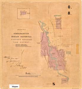
- Plan No. II of Similkameen Indian Reserves, Osoyoos Division, Yale District, British Columbia
- Subject:
- Land titles, Land cover, Indian reservations, Land use, Indigenous peoples, and Land titles--Maps
- Creator:
- Surveyor General of British Columbia
- Contributor:
- Jemmett, William Sugden, Captain, 1835-1922
- Language:
- eng
- Date Created:
- 1889 to 1890
- Rights Statement:
- No Copyright - Non-Commercial Use Only
- Resource Type:
- Still Image
- Identifier:
- LTSA Inventory No.: LTSA6173, LTSA SGD Microfilm Image Number: 106452, Plan Number: 08TR-IR (Osoyoos), Plan Barcode: Z0366451, and Osoyoos 8
- Extent:
- 1 sheet
- Geographic Coverage:
- British Columbia--Blind Creek, British Columbia--Cawston, British Columbia--Okanagan-Similkameen, and North America--Similkameen River
- Coordinates:
- 49.13305, -119.7691, 49.18254, -119.75965, 49.11645, -119.7524, and 49.18306, -119.7357
- Additional Physical Characteristics:
- Scale: 1 inch = 40 chains
- Physical Repository:
- Land Title and Survey Authority of British Columbia
- Collection:
- Land Title and Survey Authority of British Columbia: Indian Reserve Maps
- Provider:
- University of Victoria (B.C.). Library
- Genre:
- maps (documents), historical maps, and land surveys
- Technical Note:
- Cataloguing metadata: Provided by the LTSA and adapted by University of Victoria Libraries to their requirements.
- Alternative Title:
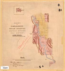
- Plan No. II of Similkameen Indian Reserves, Osoyoos Division, Yale District, British Columbia
- Subject:
- Land titles, Land titles--Maps, Land use, Indigenous peoples, Indian reservations, and Land cover
- Creator:
- Surveyor General of British Columbia
- Contributor:
- Jemmett, William Sugden, Captain, 1835-1922
- Language:
- eng
- Date Created:
- 1889 to 1890
- Rights Statement:
- No Copyright - Non-Commercial Use Only
- Resource Type:
- Still Image
- Identifier:
- LTSA Inventory No.: LTSA6173, Plan Barcode: Z0366452, Plan Number: 08ATR-IR (Osoyoos), LTSA SGD Microfilm Image Number: 106453, and Osoyoos 8A
- Extent:
- 1 sheet
- Geographic Coverage:
- North America--Similkameen River, British Columbia--Cawston, British Columbia--Blind Creek, and British Columbia--Okanagan-Similkameen
- Coordinates:
- 49.18254, -119.75965, 49.11645, -119.7524, 49.18306, -119.7357, and 49.13305, -119.7691
- Additional Physical Characteristics:
- Scale: 1 inch = 40 chains
- Physical Repository:
- Land Title and Survey Authority of British Columbia
- Collection:
- Land Title and Survey Authority of British Columbia: Indian Reserve Maps
- Provider:
- University of Victoria (B.C.). Library
- Genre:
- historical maps, maps (documents), and land surveys
- Technical Note:
- Cataloguing metadata: Provided by the LTSA and adapted by University of Victoria Libraries to their requirements.