Search
Search Results
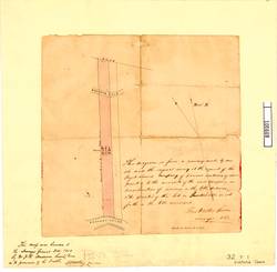
- Alternative Title:
- Diagram lots, resurvey Puget Sd Agric Co grant to servants
- Creator:
- Green, F.W.
- Language:
- eng
- Date Created:
- 1863
- Rights Statement:
- No Copyright - Non-Commercial Use Only
- Resource Type:
- Still Image
- Identifier:
- 106888, LSV Number: 32T1VT, and Historical Map Society of B.C. Map Number: 1847
- Extent:
- 1 map on 1 sheet ; 40 x 45 cm
- Geographic Coverage:
- British Columbia--Colquitz River and British Columbia--Portage Inlet
- Coordinates:
- 48.46073, -123.422 and 48.45889, -123.40979
- Additional Physical Characteristics:
- Scale: 6 chains to 1 inch
- Physical Repository:
- Land Title and Survey Authority of British Columbia
- Collection:
- Land Title and Survey Authority of British Columbia: Early British Columbia Maps
- Provenance:
- Surveyor General of BC, Legal Surveys Vault
- Provider:
- University of Victoria (B.C.). Library
- Genre:
- cadastral maps, maps (documents), and historical maps
- Date Digitized:
- 2018-02-26
- Technical Note:
- Cataloguing metadata: Provided by the LTSA and adapted by the University of Victoria Libraries to their requirements.