Search
Search Results
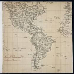
- Alternative Title:
- America, the eastern Pacific and Atlantic Oceans, the British Isles, France, Spain and West Africa
- Subject:
- Great Britain. Royal Navy and Great Britain. Royal Navy. British Pacific Fleet
- Contributor:
- Baynes, Robert Lambert
- Language:
- eng
- Date Created:
- 1859
- Rights Statement:
- In Copyright - Educational Use Permitted
- Resource Type:
- Still Image
- Extent:
- 1 sheet
- Geographic Coverage:
- Atlantic Ocean, France, Pacific Ocean, Great Britain, West Africa, Spain, Europe--British Isles, South America, North America, and Central America
- Coordinates:
- 46, 2, 10, -25, -14.60485, -57.65625, 54, -4, 46.07323, -100.54688, 3.51342, -132.1875, 40, -4, 25.32417, -99.66797, and 54, -2
- Chronological Coverage:
- 185X
- Additional Physical Characteristics:
- 1:50,688,000
- Physical Repository:
- National Archives (Great Britain)
- Collection:
- Early BC Maps Collection
- Provenance:
- National Archives of the UK
- Provider:
- University of Victoria (B.C.). Library
- Genre:
- maps (documents) and historical maps
- Date Digitized:
- 2010-04-12
- Technical Note:
- 600 dpi jpg and Watermarks added to images by KM, JF, and CDW. Metadata by JTP April 28, 2010.
- Subject:
- Trade routes, Exploration routes, and Ocean travel
- Creator:
- Trivett, J. F.
- Language:
- eng
- Date Created:
- approximately 1860
- Rights Statement:
- No Copyright - Contractual restrictions
- Resource Type:
- Still Image
- Identifier:
- G1/176 and Ruggles Number: 480A
- Extent:
- 1 sheet ; 66 x 53.2 cm
- Geographic Coverage:
- North America, Great Britain, and South America
- Coordinates:
- -14.60485, -57.65625, 46.07323, -100.54688, and 52.16045, -0.70312
- Additional Physical Characteristics:
- 1:26,928,000
- Physical Repository:
- Hudson's Bay Company. Archives
- Collection:
- Early B.C. Maps from the Hudson's Bay Company Archives
- Provider:
- University of Victoria (B.C.). Library
- Genre:
- maps (documents) and historical maps
- Date Digitized:
- 2013-05-10
- Transcript:
- 1 inch:ca. 425 miles at Equator
- Alternative Title:
- Velhos vizinhos, novas histórias! Mapa Arqueológico da Cidade de Sorocaba
- Subject:
- Archaeology
- Creator:
- Mapa Verde Sorocaba
- Contributor:
- Bernardo, Wanderson Esquerdo
- Publisher:
- Green Map System
- Language:
- por
- Date Created:
- 2008
- Rights Statement:
- In Copyright - Educational Use Permitted
- Resource Type:
- Text
- Extent:
- 1 map : colour
- Geographic Coverage:
- South America and Brazil--Sorocaba
- Coordinates:
- -23.50167, -47.45806 and -14.60485, -57.65625
- Chronological Coverage:
- 2008
- Collection:
- International Green Maps
- Provenance:
- Digital files provided by Green Map System, New York, NY.
- Provider:
- University of Victoria (B.C.). Library
- Genre:
- maps (documents)
- Date Digitized:
- 2013-10-18
- Technical Note:
- Adobe PDF. Received in digital format. Metadata by PD and MT.