Search
Search Results

- Alternative Title:
- Exploration du territoire de l'Orégon, des Californies et de la mer Vermeille, exécutée pendant les années 1840, 1841 et 1842
- Subject:
- Hudson's Bay Company
- Creator:
- Duflot de Mofras, Eugène, 1810-1884
- Contributor:
- Hacq, J. M. and Jacobs, S.
- Publisher:
- Arthur Bertrand
- Language:
- eng
- Date Created:
- 1844
- Rights Statement:
- In Copyright - Educational Use Permitted
- Resource Type:
- Still Image
- Extent:
- 1 sheet
- Geographic Coverage:
- California, Canada, British Columbia, Mexico, Washington (State), North America--Northwest Coast of North America, Oregon, and Alaska
- Coordinates:
- 64.00028, -150.00028, 23, -102, 60N-17N/145W-89W, 53.99983, -125.0032, 44.00013, -120.50139, 60.10867, -113.64258, 37.25022, -119.75126, and 47.50012, -120.50147
- Chronological Coverage:
- 1844
- Additional Physical Characteristics:
- 1:5,555,555
- Physical Repository:
- National Archives (Great Britain)
- Collection:
- Early BC Maps Collection
- Provenance:
- National Archives of the UK
- Provider:
- University of Victoria (B.C.). Library
- Genre:
- maps (documents) and historical maps
- Date Digitized:
- 2010-04-12
- Technical Note:
- Watermarks added to images by KM, JF, and CDW. Metadata by JTP May 6, 2010. and 600 dpi jpg
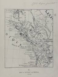
- Alternative Title:
- Map of Duflot de Mofras, 1844
- Subject:
- San Juan Boundary Dispute (1846-1872)
- Creator:
- Duflot de Mofras, Eugène, 1810-1884
- Contributor:
- Hacq, J. M. and Jacobs, S.
- Publisher:
- Harrison & Sons Lith.
- Language:
- eng
- Date Created:
- 1844
- Rights Statement:
- In Copyright - Educational Use Permitted
- Resource Type:
- Still Image
- Identifier:
- Penfold Number: 376
- Extent:
- 1 sheet
- Geographic Coverage:
- British Columbia, Washington (State), British Columbia--Vancouver Island, and Pacific Ocean--Strait of Juan de Fuca
- Coordinates:
- 49.65064, -125.44939, 48.29674, -124.01225, 53.99983, -125.0032, 47.50012, -120.50147, and 52N-47N
- Chronological Coverage:
- 1844/1873
- Physical Repository:
- National Archives (Great Britain)
- Collection:
- Early BC Maps Collection
- Provenance:
- National Archives of the UK
- Provider:
- University of Victoria (B.C.). Library
- Genre:
- maps (documents) and historical maps
- Archival Item Identifier:
- National Archives Number: FO925-1649 (e)
- Date Digitized:
- 2010-04-12
- Technical Note:
- 600 dpi jpg and Watermarks added to images by KM, JF, and CDW. Metadata by JTP May 10, 2010.