Search
Search Results
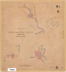
- Alternative Title:
- Plan of the Upper Kootenay Indian Reserves and Plan No. 4 of the Upper Kootenay Indian Reserves, British Columbia
- Subject:
- Indigenous peoples, Indian reservations, Land titles--Maps, Land use, Land titles, and Land cover
- Creator:
- Surveyor General of British Columbia
- Contributor:
- Cummins, Arthur Patrick, 1853-1936 and McVittie, Thomas Thane, 1855-1918
- Language:
- eng
- Date Created:
- approximately 1886
- Rights Statement:
- No Copyright - Non-Commercial Use Only
- Resource Type:
- Still Image
- Identifier:
- Kootenay 6, LTSA Inventory No.: LTSA6170, Plan Barcode: Z0366385, LTSA SGD Microfilm Image Number: 106397, and Plan Number: 06TR-IR (Kootenay)
- Extent:
- 1 sheet
- Geographic Coverage:
- British Columbia--East Kootenay, North America--Kootenai River, and British Columbia--St. Mary River
- Coordinates:
- 49.61664, -115.65208, 49.91664, -115.75209, and 49.54993, -115.61877
- Additional Physical Characteristics:
- Scale: 1 inch = 40 chains
- Physical Repository:
- Land Title and Survey Authority of British Columbia
- Collection:
- Land Title and Survey Authority of British Columbia: Indian Reserve Maps
- Provider:
- University of Victoria (B.C.). Library
- Genre:
- land surveys, historical maps, and maps (documents)
- Technical Note:
- Cataloguing metadata: Provided by the LTSA and adapted by University of Victoria Libraries to their requirements.

- Subject:
- Indigenous peoples, Land titles, Land titles--Maps, Indian reservations, Land cover, and Land use
- Creator:
- Surveyor General of British Columbia
- Contributor:
- McVittie, Thomas Thane, 1855-1918
- Language:
- eng
- Rights Statement:
- No Copyright - Non-Commercial Use Only
- Resource Type:
- Still Image
- Identifier:
- LTSA Inventory No.: LTSA6170, LTSA SGD Microfilm Image Number: 106399, Plan Number: 08TR-IR (Kootenay), Kootenay 8, and Plan Barcode: Z0366387
- Extent:
- 1 sheet
- Geographic Coverage:
- British Columbia--Central Kootenay, North America--Kootenai River, and British Columbia--Goat River
- Coordinates:
- 49.91655, -117.50222 and 49.08317, -116.56881
- Additional Physical Characteristics:
- Scale: 1 inch = 40 chains
- Physical Repository:
- Land Title and Survey Authority of British Columbia
- Collection:
- Land Title and Survey Authority of British Columbia: Indian Reserve Maps
- Provider:
- University of Victoria (B.C.). Library
- Genre:
- maps (documents), historical maps, and land surveys
- Technical Note:
- Cataloguing metadata: Provided by the LTSA and adapted by University of Victoria Libraries to their requirements.