Search
Search Results
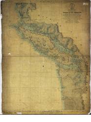
- Alternative Title:
- Chart showing part of the Coast of N. W. America
- Subject:
- Coasts and San Juan Boundary Dispute (1846-1872)
- Creator:
- Baker, Joseph, 1768-1817
- Contributor:
- Vancouver, George, 1757-1798
- Publisher:
- J. Edwards & G. Robinson
- Language:
- eng
- Date Created:
- 1798
- Rights Statement:
- In Copyright - Educational Use Permitted
- Resource Type:
- Still Image
- Identifier:
- Penfold Number: 365
- Extent:
- 1 sheet
- Geographic Coverage:
- British Columbia, Washington (State), British Columbia--Vancouver Island, and Pacific Ocean--Strait of Juan de Fuca
- Coordinates:
- 47.50012, -120.50147, 48.29674, -124.01225, 49.65064, -125.44939, 53 15'N-45 30'N/129 30:W-122W, and 53.99983, -125.0032
- Chronological Coverage:
- 1798
- Additional Physical Characteristics:
- 1:950,400
- Physical Repository:
- National Archives (Great Britain)
- Collection:
- Early BC Maps Collection
- Provenance:
- National Archives of the UK
- Provider:
- University of Victoria (B.C.). Library
- Genre:
- maps (documents) and historical maps
- Archival Item Identifier:
- National Archives Number: CO700-BRITISH COLUMBIA1
- Date Digitized:
- 2010-04-12
- Technical Note:
- Watermarks added to images by KM, JF, and CDW. Metadata by JTP April 22, 2010. and 600 dpi jpg