Search Constraints
Filtering by:
Creator
City of Cape Town (South Africa)
Remove constraint Creator: City of Cape Town (South Africa)
1 - 3 of 3
Number of results to display per page
Search Results

- Alternative Title:
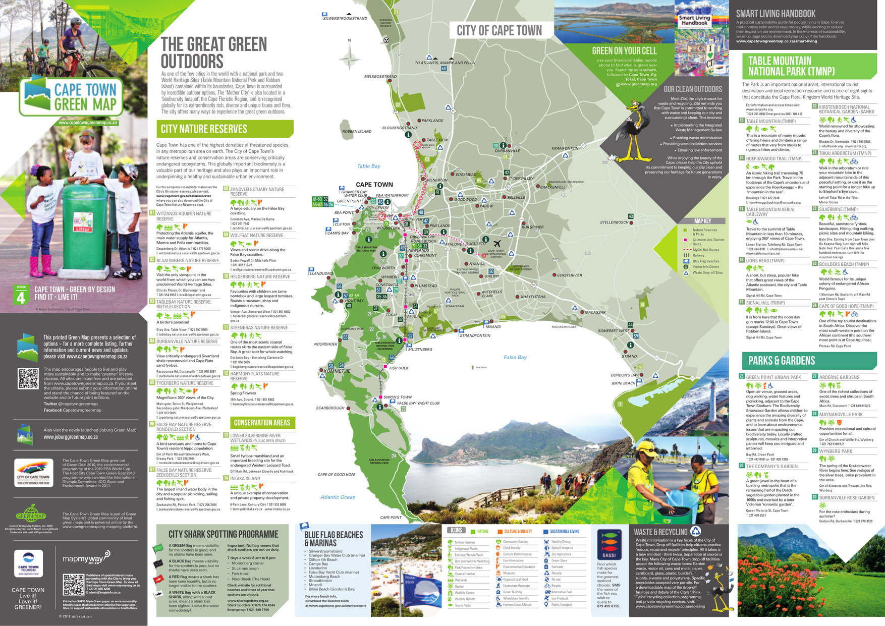
- The great green outdoors
- Subject:
- Wetland conservation, Outdoor recreation, Watersheds, Natural areas, and Parks
- Creator:
- City of Cape Town (South Africa)
- Publisher:
- A&C Maps
- Language:
- eng
- Date Created:
- 2013
- Rights Statement:
- In Copyright - Educational Use Permitted
- License:
- This material is made available on this site for research and private study only.
- Resource Type:
- Text
- Identifier:
- Green Map System Number: AF1
- Extent:
- 1 map : colour
- Edition:
- 4th edition
- Geographic Coverage:
- South Africa--Cape Town
- Coordinates:
- -33.92584, 18.42322
- Chronological Coverage:
- 2013
- Collection:
- International Green Maps
- Provenance:
- Digital files provided by Green Map System, New York, NY.
- Provider:
- University of Victoria (B.C.). Library
- Genre:
- maps (documents)
- Date Digitized:
- 2013-01-11
- Technical Note:
- Adobe PDF. Received in digital format. Metadata by PD and MT.
- Keyword in Context:
- Transcript available<br/>This printed Green Map presents a selection of options – for a more complete listing, further information and current news and updates please visit www.capetowngreenmap.co.za Printed on SAPPI Triple Green paper, an environmentally- friendly paper stock made from chlor...

- Alternative Title:
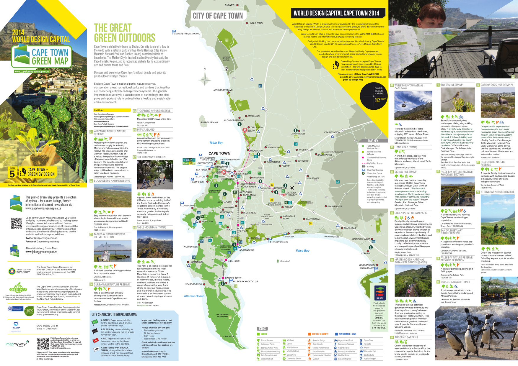
- The great green outdoors
- Subject:
- Recreation areas, Outdoor recreation, Beaches, Parks, and Nature conservation
- Creator:
- City of Cape Town (South Africa)
- Publisher:
- A&C Maps
- Language:
- eng
- Date Created:
- 2014
- Rights Statement:
- In Copyright - Educational Use Permitted
- License:
- This material is made available on this site for research and private study only.
- Resource Type:
- Still Image
- Identifier:
- Green Map System Number: AF1
- Extent:
- 1 map : colour
- Edition:
- 5th edition
- Geographic Coverage:
- South Africa--Cape Town
- Coordinates:
- -33.92584, 18.42322
- Chronological Coverage:
- 2014
- Collection:
- International Green Maps
- Provenance:
- Digital files provided by Green Map System, New York, NY.
- Provider:
- University of Victoria (B.C.). Library
- Genre:
- maps (documents)
- Date Digitized:
- 2018-03-28
- Technical Note:
- Adobe PDF. Received in digital format. Metadata by PD and MT.
- Keyword in Context:
- Transcript available<br/>TOKAI CAPE TOWN INTERNATIONAL AIRPORT KOMMETJIE ATLANTIS MAMRE ZEEKOEIVLEI ZANDVLEI RONDEVLEI Seal Island CHAPMAN’S PEAK FALSE BAY NATURE RESERVE Table Bay CAPE TOWN TABLE MOUNTAIN NATIONAL PARK (SILVERMINE) TABLE MOUNTAIN NATIONAL PARK TABLE MOUNTAIN NA...

- Alternative Title:
- Discover the Nedbank Green Wine route
- Subject:
- Vineyards, Nature conservation, Wine and wine making, and Vintners
- Creator:
- City of Cape Town (South Africa)
- Publisher:
- A&C Maps
- Language:
- eng
- Date Created:
- 2015
- Rights Statement:
- In Copyright - Educational Use Permitted
- License:
- This material is made available on this site for research and private study only.
- Resource Type:
- Still Image
- Identifier:
- Green Map System Number: AF1
- Extent:
- 1 map : colour
- Edition:
- 6th edition
- Geographic Coverage:
- South Africa--Cape Town
- Coordinates:
- -33.92584, 18.42322
- Chronological Coverage:
- 2015
- Collection:
- International Green Maps
- Provenance:
- Digital files provided by Green Map System, New York, NY.
- Provider:
- University of Victoria (B.C.). Library
- Genre:
- maps (documents)
- Date Digitized:
- 2018-03-28
- Technical Note:
- Adobe PDF. Received in digital format. Metadata by PD and MT.
- Keyword in Context:
- Transcript available<br/>TO CALEDON and GEORGE BOT RIVER STANFORD TO HERMANUS FALSE BAY TO MALMESBURY CAPE TOWN BELLVILLE WINELANDS GREEN POINT V&A WATERFRONT WOODSTOCK PAROW DURBANVILLE WELLINGTON STELLENBOSCH SOMERSET WEST CAMPS BAY HOUT BAY SEA POINT BLOUBERGSTRAND CLIFT...