Search
Search Results
- Subject:
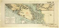
- Canadian Pacific Railway Company and Nautical charts
- Creator:
- Fleming, Sandford, 1827-1915
- Publisher:
- Burland Desbarats Lith. Co
- Language:
- eng
- Date Created:
- 1878 to 1879
- Rights Statement:
- In Copyright - Educational Use Permitted
- Resource Type:
- Still Image
- Identifier:
- Penfold Number: 436
- Extent:
- 1 sheet
- Geographic Coverage:
- British Columbia and British Columbia--Vancouver Island
- Coordinates:
- 49 20'N--48 10'N / 126 10'W--121 40'W, 49.65064, -125.44939, and 53.99983, -125.0032
- Chronological Coverage:
- 1877
- Additional Physical Characteristics:
- 1:792,000
- Physical Repository:
- National Archives (Great Britain)
- Collection:
- Early BC Maps Collection
- Provenance:
- National Archives of the UK
- Provider:
- University of Victoria (B.C.). Library
- Genre:
- maps (documents) and historical maps
- Archival Item Identifier:
- National Archives Number: WO78-2311 (23)
- Date Digitized:
- 2010-04-12
- Transcript:
- To accompany my report of this day's date, J.B. Lovell, Colonel Commndg. Rl. Engr., Halifax, N.S. 20th Dec. 1879
- Technical Note:
- Watermarks added to images by KM, JF, and CDW. Metadata by CDW, April 30, 2010 and 600 dpi jpg