Search
Search Constraints
Start Over Filtering by: Genre maps (documents) ✖ Remove constraint Genre: maps (documents) Subject Cycling ✖ Remove constraint Subject: Cycling
« Previous |
1 - 10 of 14
|
Next »
Number of results to display per page
Search Results
-

- Alternative Title
- Philadelphus Green Map, Wakulla Green Map, Red Banks Green Map, Maxton Green Map, Pembroke Green Map, Alma Green Map, and Red Springs Green Map
- Subject
- Recreation areas, Recycling (Waste, etc.), Farmers' markets, Parks, Community centers, Gardens, Cycling, Sewage, Plants, Water treatment plants--Waste disposal, and Environmental education
- Creator
- Robeson County Green Map Project
- Contributor
- Robeson County Green Map Project
- Publisher
- Robeson County Green Map Project
- Language
- eng
- Rights Statement
- In Copyright - Educational Use Permitted
- Resource Type
- Text
- Identifier
- Green Map System Number: US85
- Extent
- 1 map : colour ; 35 x 21 cm
- Geographic Coverage
- North Carolina--Pembroke, United States, North Carolina--Alma, North Carolina--Red Banks, North Carolina--Robeson County, North Carolina--Wakulla, North Carolina--Maxton, North Carolina--Philadelphus, and North Carolina--Red Springs
- Coordinates
- 34.70294, -79.25087, 34.75905, -79.17142, 34.73516, -79.34893, 34.72377, -79.31254, 34.64009, -79.10353, 34.68016, -79.19504, 34.79266, -79.25504, 39.76, -98.5, and 34.81516, -79.18309
- Collection
- International Green Maps
- Provenance
- Digital files provided by Green Map System, New York, NY.
- Provider
- University of Victoria (B.C.). Library
- Genre
- maps (documents)
- Date Digitized
- 2004-05-06
- Technical Note
- 200 dpi TIFF. Received in digital format. Metadata by PD and MT.
-

- Subject
- Farmers' markets, Museums, Trees, Local transit, Shrines, Wetlands, Gardens, Japanese, Cycling, Forests and forestry, Sustainable buildings, Water--Purification, Thrift shops, and Environmental education
- Creator
- Tennen Design Forum
- Language
- jpn and eng
- Date created
- 1997
- Rights Statement
- In Copyright - Educational Use Permitted
- Resource Type
- Text
- Identifier
- Green Map System Number: JP23
- Extent
- 1 map : colour ; 59 x 42 cm
- Edition
- 1st edition
- Geographic Coverage
- Japan--Kyoto
- Coordinates
- 35.02107, 135.75385
- Chronological Coverage
- 1997
- Collection
- International Green Maps
- Provenance
- Digital files provided by Green Map System, New York, NY.
- Provider
- University of Victoria (B.C.). Library
- Genre
- maps (documents)
- Date Digitized
- 2007-06-07
- Technical Note
- Adobe PDF. Received in digital format. Metadata by PD and MT.
-

- Alternative Title
- Green Bike Map of North Brabant
- Subject
- Cycling
- Creator
- Regionaal Overleg Natuur-en Milieucommunicatie Noord-Brabant
- Contributor
- Foks, Renate and Ad Vermeulen
- Publisher
- Drukkerij Damen (Werkendam)
- Language
- dut
- Date created
- 1999
- Rights Statement
- In Copyright - Educational Use Permitted
- Resource Type
- Still Image
- Identifier
- Green Map System Number: EU19
- Extent
- 1 map : colour ; 59 x 41 cm
- Geographic Coverage
- Netherlands--North Brabant
- Coordinates
- 51.44083, 5.47778
- Chronological Coverage
- 1999
- Collection
- International Green Maps
- Provenance
- Digital files provided by Green Map System, New York, NY.
- Provider
- University of Victoria (B.C.). Library
- Genre
- maps (documents)
- Date Digitized
- 2007-06-11
- Technical Note
- Adobe PDF. Received in digital format. Metadata by PD and MT.
-
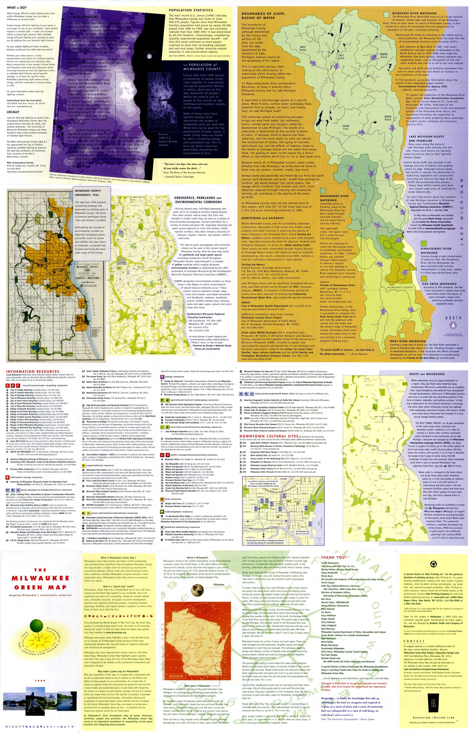
- Subject
- Renewable energy sources, Watersheds, Culture, Thrift shops, Environmental education, Farmers' markets, Cycling, Natural areas, Wildlife conservation, Community gardens, Population--Statistics, Parks, Fair trade foods, Open spaces, Local transit, Animals, and Recycling (Waste, etc.)
- Creator
- Milwaukee Green Map Project
- Contributor
- Groshek, Matthew
- Publisher
- Sells Printing Co.
- Language
- eng
- Date created
- 1999
- Rights Statement
- In Copyright - Educational Use Permitted
- Resource Type
- Still Image
- Identifier
- Green Map System Number: US52
- Extent
- 1 map : colour ; 86 x 55 cm
- Geographic Coverage
- Wisconsin--Milwaukee and United States
- Coordinates
- 39.76, -98.5 and 43.0389, -87.90647
- Chronological Coverage
- 1999
- Collection
- International Green Maps
- Provenance
- Digital files provided by Green Map System, New York, NY.
- Provider
- University of Victoria (B.C.). Library
- Genre
- maps (documents)
- Date Digitized
- 2007-06-11
- Technical Note
- Adobe PDF. Received in digital format. Metadata by PD and MT.
-

- Subject
- Sustainable buildings, Natural foods, Recycling (Waste, etc.), Farmers' markets, Renewable energy sources, Cycling, Gardens, Fair trade foods, Trails, and Environmental education
- Contributor
- Flint, Niels Peter and Blomhoj, Michael
- Publisher
- Ecooperation
- Language
- eng
- Date created
- 1999? to 2000?
- Rights Statement
- In Copyright - Educational Use Permitted
- Resource Type
- Text
- Identifier
- Green Map System Number: EU52
- Extent
- 1 map : colour ; 62 x 27 cm
- Geographic Coverage
- Denmark--Copenhagen
- Coordinates
- 55.67594, 12.56553
- Collection
- International Green Maps
- Provenance
- Digital files provided by Green Map System, New York, NY.
- Provider
- University of Victoria (B.C.). Library
- Genre
- maps (documents)
- Date Digitized
- 2007-06-19
- Technical Note
- Adobe PDF. Received in digital format. Metadata by PD and MT.
-
Go Green NYC: getting around without a car, charted by Recycle-A-Bicycle's 2001 Summer Youth Program
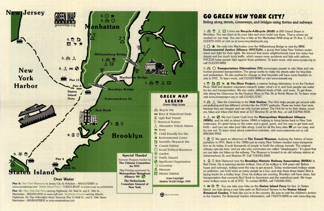
- Alternative Title
- Go Green New York City!
- Subject
- Cycling
- Creator
- Recycle-A-Bicycle (Organization)
- Contributor
- Troncoso, Kendall, Rosa, Thomas, Wallace, Darrell, Comez, Ricardo, Rashel, Mohammed, Stallings, Jamil, Ahmed, Aminullah, Hines, Dain, Barnes, Julius, and Cox, Leroy
- Publisher
- Recycle-A-Bicycle
- Language
- eng
- Date created
- 2001
- Rights Statement
- In Copyright - Educational Use Permitted
- Resource Type
- Text
- Identifier
- Green Map System Number: US8
- Extent
- 1 map : colour ; 27 x 43 cm
- Geographic Coverage
- United States and New York (State)--New York
- Coordinates
- 39.76, -98.5 and 40.71427, -74.00597
- Chronological Coverage
- 2001
- Collection
- International Green Maps
- Provenance
- Digital files provided by Green Map System, New York, NY.
- Provider
- University of Victoria (B.C.). Library
- Genre
- maps (documents)
- Date Digitized
- 2007-06-19
- Technical Note
- Adobe PDF. Received in digital format. Metadata by PD and MT.
-

- Alternative Title
- Sabin neighborhood greenmap: a Portland Greenmap pilot project sponsored by Nature's Northwest
- Subject
- Public art, Cycling, Libraries, Playgrounds, Community centers, Habitat (Ecology), Parks, Natural foods, Community gardens, Thrift shops, Forests and forestry, and Environmental education
- Creator
- Portland Greenmap
- Contributor
- King, Jason and Kausfamann, Cathy
- Publisher
- Portland Greenmap
- Language
- eng
- Date created
- 2001
- Rights Statement
- In Copyright - Educational Use Permitted
- Resource Type
- Still Image
- Identifier
- Green Map System Number: US38
- Extent
- 1 map : colour ; 27 x 43 cm
- Geographic Coverage
- Oregon--Portland and United States
- Coordinates
- 45.52345, -122.67621 and 39.76, -98.5
- Chronological Coverage
- 2001
- Collection
- International Green Maps
- Provenance
- Digital files provided by Green Map System, New York, NY.
- Provider
- University of Victoria (B.C.). Library
- Genre
- maps (documents)
- Date Digitized
- 2007-06-19
- Technical Note
- Adobe PDF. Received in digital format. Metadata by PD and MT.
-

- Alternative Title
- Victoria Falls municipal green map
- Subject
- Natural areas, Parks, Farmers' markets, Sustainable buildings, Deforestation, Waterfalls, Local transit, Forests and forestry, Soil erosion, Habitat (Ecology), Animals, Renewable energy sources, Plants, and Cycling
- Creator
- Victoria Falls Environmental Capacity and Master Plan Project
- Contributor
- Victoria Falls Environmental Capacity and Master Plan Project
- Publisher
- Victoria Falls Environmental Capacity and Master Plan Project
- Language
- eng
- Date created
- 2001
- Rights Statement
- In Copyright - Educational Use Permitted
- Resource Type
- Still Image
- Identifier
- Green Map System Number: AF5
- Extent
- 1 map : colour ; 42 x 27 cm
- Geographic Coverage
- Africa--Victoria Falls and Zimbabwe--Victoria Falls
- Coordinates
- -17.93285, 25.83066
- Chronological Coverage
- 2000
- Collection
- International Green Maps
- Provenance
- Digital files provided by Green Map System, New York, NY.
- Provider
- University of Victoria (B.C.). Library
- Genre
- maps (documents)
- Date Digitized
- 2007-06-19
- Technical Note
- Adobe PDF. Received in digital format. Metadata by PD and MT.
-

- Alternative Title
- 珍珠社区绿色生活地图
- Subject
- Natural areas, Local transit, Recycling (Waste, etc.), Museums, Wetlands, Parks, Trees, Animals, Yi lan xian dong shan xiang, Public art, and Cycling
- Creator
- Lin, Yuhuan
- Contributor
- Development Committee of Zhenzhu Community
- Publisher
- Taiwan Society of Wilderness
- Language
- chi
- Date created
- 2003
- Rights Statement
- In Copyright - Educational Use Permitted
- Resource Type
- Text
- Identifier
- Green Map System Number: TW39
- Extent
- 1 map : colour ; 50 x 36 cm
- Geographic Coverage
- Taiwan--Yilan County
- Coordinates
- 46.26085, 129.70666
- Chronological Coverage
- 2003
- Collection
- International Green Maps
- Provenance
- Digital files provided by Green Map System, New York, NY.
- Provider
- University of Victoria (B.C.). Library
- Genre
- maps (documents)
- Date Digitized
- 2004-06-22
- Technical Note
- 300 dpi TIFF. Born digital resource. Metadata by PD and MT.
-

- Alternative Title
- Menteng Green Map
- Subject
- Museums, Water--Pollution, Open spaces, Air--Pollution, Sustainable buildings, Culture, Animals, Parks, Livestock, Cycling, Community centers, Gardens, Community gardens, Local transit, Trees, and Water treatment plants--Waste disposal
- Creator
- Green Mappers Jakarta (Firm)
- Publisher
- Green Mappers Jakarta
- Language
- eng and may
- Date created
- 2004
- Rights Statement
- In Copyright - Educational Use Permitted
- Resource Type
- Text
- Identifier
- Green Map System Number: AS20
- Extent
- 1 map : colour ; 58 x 41 cm
- Geographic Coverage
- Indonesia--Jakarta
- Coordinates
- -6.21462, 106.84513
- Chronological Coverage
- 2003
- Collection
- International Green Maps
- Provenance
- Digital files provided by Green Map System, New York, NY.
- Provider
- University of Victoria (B.C.). Library
- Genre
- maps (documents)
- Date Digitized
- 2018-03-26
- Technical Note
- Adobe PDF. Received in digital format. Metadata by PD and MT.
- Keyword in Context
- ! ~ I ; KH. W ID HASYIM ~ ~ i~5 0.....,43,___......_ \ t I lndeks + Peta Hijau Sungai Ciliwung/lndex + Ciliwung River Green Map I . ; I --~-...of--- l __ _ ~----, I I I I I --. --~--~- ------- mailinglist: greenmapindonesia@yahoogroups.com...