Search
Search Constraints
Start Over Filtering by: Genre maps (documents) ✖ Remove constraint Genre: maps (documents) Subject Parks ✖ Remove constraint Subject: Parks
« Previous |
1 - 10 of 26
|
Next »
Number of results to display per page
Search Results
-

- Subject
- Parks
- Creator
- Pemberton, J. Despard (Joseph Despard), 1821-1893
- Contributor
- Location
- Language
- eng
- Date created
- May 4, 1864
- Rights Statement
- No Copyright - Non-Commercial Use Only
- Resource Type
- Still Image
- Identifier
- 106929 and LSV Number: 30T2VIC TOWN
- Extent
- 1 sheet ; 59 x 95 cm
- Geographic Coverage
- British Columbia--Victoria
- Coordinates
- 48.41222, -123.36243
- Additional Physical Characteristics
- Scale: 4 Chain to 1 inch
- Physical Repository
- Land Title and Survey Authority of British Columbia
- Collection
- Land Title and Survey Authority of British Columbia: Early British Columbia Maps
- Provenance
- Surveyor General of BC, Legal Surveys Vault
- Provider
- University of Victoria (B.C.). Library
- Genre
- historical maps, relief maps, cadastral maps, and maps (documents)
- Date Digitized
- 2011-11-14
- Technical Note
- Cataloguing metadata: Provided by the LTSA and adapted by the University of Victoria Libraries to their requirements.
-

- Alternative Title
- Philadelphus Green Map, Wakulla Green Map, Red Banks Green Map, Maxton Green Map, Pembroke Green Map, Alma Green Map, and Red Springs Green Map
- Subject
- Recreation areas, Recycling (Waste, etc.), Farmers' markets, Parks, Community centers, Gardens, Cycling, Sewage, Plants, Water treatment plants--Waste disposal, and Environmental education
- Creator
- Robeson County Green Map Project
- Contributor
- Robeson County Green Map Project
- Publisher
- Robeson County Green Map Project
- Language
- eng
- Rights Statement
- In Copyright - Educational Use Permitted
- Resource Type
- Text
- Identifier
- Green Map System Number: US85
- Extent
- 1 map : colour ; 35 x 21 cm
- Geographic Coverage
- North Carolina--Pembroke, United States, North Carolina--Alma, North Carolina--Red Banks, North Carolina--Robeson County, North Carolina--Wakulla, North Carolina--Maxton, North Carolina--Philadelphus, and North Carolina--Red Springs
- Coordinates
- 34.70294, -79.25087, 34.75905, -79.17142, 34.73516, -79.34893, 34.72377, -79.31254, 34.64009, -79.10353, 34.68016, -79.19504, 34.79266, -79.25504, 39.76, -98.5, and 34.81516, -79.18309
- Collection
- International Green Maps
- Provenance
- Digital files provided by Green Map System, New York, NY.
- Provider
- University of Victoria (B.C.). Library
- Genre
- maps (documents)
- Date Digitized
- 2004-05-06
- Technical Note
- 200 dpi TIFF. Received in digital format. Metadata by PD and MT.
-

- Subject
- Parks, Water treatment plants--Waste disposal, Water--Purification, Recycling (Waste, etc.), Natural areas, Habitat (Ecology), Sewage, Local transit, Compost, Natural foods, Environmental management, Museums, and Farmers' markets
- Creator
- Miller, Gayle
- Publisher
- Mid-Michigan Green Map
- Language
- eng
- Date created
- 1995
- Rights Statement
- In Copyright - Educational Use Permitted
- Resource Type
- Text
- Identifier
- Green Map System Number: US31
- Extent
- 1 map : colour ; 62 x 47 cm
- Geographic Coverage
- Michigan--Eaton County, Michigan--Shiawassee County, Michigan--Ingham County, Michigan--Ionia County, United States, Michigan, and Michigan--Clinton County
- Coordinates
- 44.25029, -85.50033, 42.5971, -84.37354, 42.94509, -85.0746, 42.95373, -84.14673, 42.59607, -84.83831, 39.76, -98.5, and 42.94365, -84.60152
- Chronological Coverage
- 1995
- Collection
- International Green Maps
- Provenance
- Digital files provided by Green Map System, New York, NY.
- Provider
- University of Victoria (B.C.). Library
- Genre
- maps (documents)
- Date Digitized
- 2007-06-19
- Technical Note
- Adobe PDF. Received in digital format. Metadata by PD and MT.
-

- Subject
- Community gardens, Parks, and Recycling (Waste, etc.)
- Creator
- Architects, Designers, Planners for Social Responsibility. Northern California Chapter
- Contributor
- Garcia, Carol, Novik, Linda, Lytle, Jacqueline, Van Mechelen, Greg, Smith, Kathleen, and Merola, Linda
- Publisher
- Inkworks Press
- Language
- eng
- Date created
- 1998
- Rights Statement
- In Copyright - Educational Use Permitted
- Resource Type
- Still Image
- Identifier
- Green Map System Number: US19
- Extent
- 1 map : colour ; 27 x 43 cm
- Geographic Coverage
- California--Berkeley and United States
- Coordinates
- 39.76, -98.5 and 37.87159, -122.27275
- Chronological Coverage
- 1998
- Collection
- International Green Maps
- Provenance
- Digital files provided by Green Map System, New York, NY.
- Provider
- University of Victoria (B.C.). Library
- Genre
- maps (documents)
- Date Digitized
- 2007-06-11
- Technical Note
- Adobe PDF. Received in digital format. Metadata by PD and MT.
-
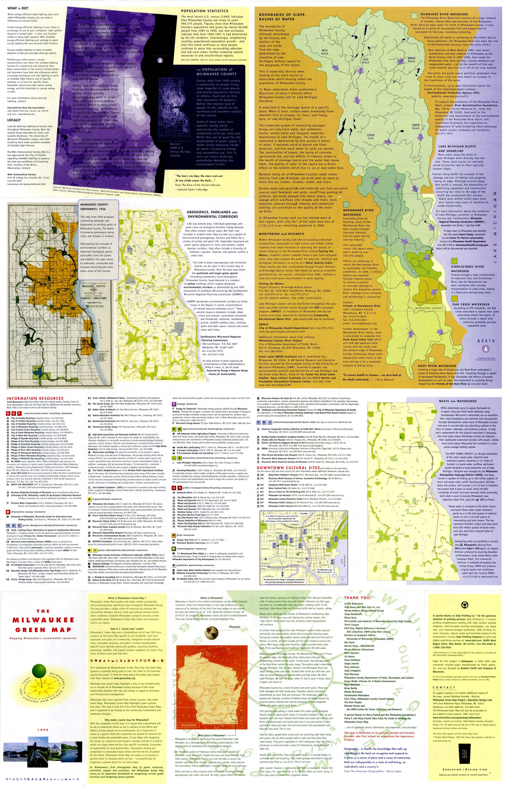
- Subject
- Renewable energy sources, Watersheds, Culture, Thrift shops, Environmental education, Farmers' markets, Cycling, Natural areas, Wildlife conservation, Community gardens, Population--Statistics, Parks, Fair trade foods, Open spaces, Local transit, Animals, and Recycling (Waste, etc.)
- Creator
- Milwaukee Green Map Project
- Contributor
- Groshek, Matthew
- Publisher
- Sells Printing Co.
- Language
- eng
- Date created
- 1999
- Rights Statement
- In Copyright - Educational Use Permitted
- Resource Type
- Still Image
- Identifier
- Green Map System Number: US52
- Extent
- 1 map : colour ; 86 x 55 cm
- Geographic Coverage
- Wisconsin--Milwaukee and United States
- Coordinates
- 39.76, -98.5 and 43.0389, -87.90647
- Chronological Coverage
- 1999
- Collection
- International Green Maps
- Provenance
- Digital files provided by Green Map System, New York, NY.
- Provider
- University of Victoria (B.C.). Library
- Genre
- maps (documents)
- Date Digitized
- 2007-06-11
- Technical Note
- Adobe PDF. Received in digital format. Metadata by PD and MT.
-

- Subject
- Wetlands, Parks, Recreation areas, Remote-sensing images, Natural areas, and Outdoor recreation
- Creator
- Sustainable Calgary
- Contributor
- Canada Millennium Partnership Program
- Publisher
- City of Calgary
- Language
- eng
- Date created
- 2000
- Rights Statement
- In Copyright - Educational Use Permitted
- Resource Type
- Still Image
- Identifier
- Green Map System Number: CA16
- Extent
- 1 map : colour ; 83 x 59 cm
- Geographic Coverage
- Alberta--Calgary
- Coordinates
- 51.05011, -114.08529
- Chronological Coverage
- 2000/2001
- Collection
- International Green Maps
- Provenance
- Digital files provided by Green Map System, New York, NY.
- Provider
- University of Victoria (B.C.). Library
- Genre
- maps (documents) and satellite imagery
- Date Digitized
- 2007-05-19
- Technical Note
- Adobe PDF. Received in digital format. Metadata by PD and MT.
-
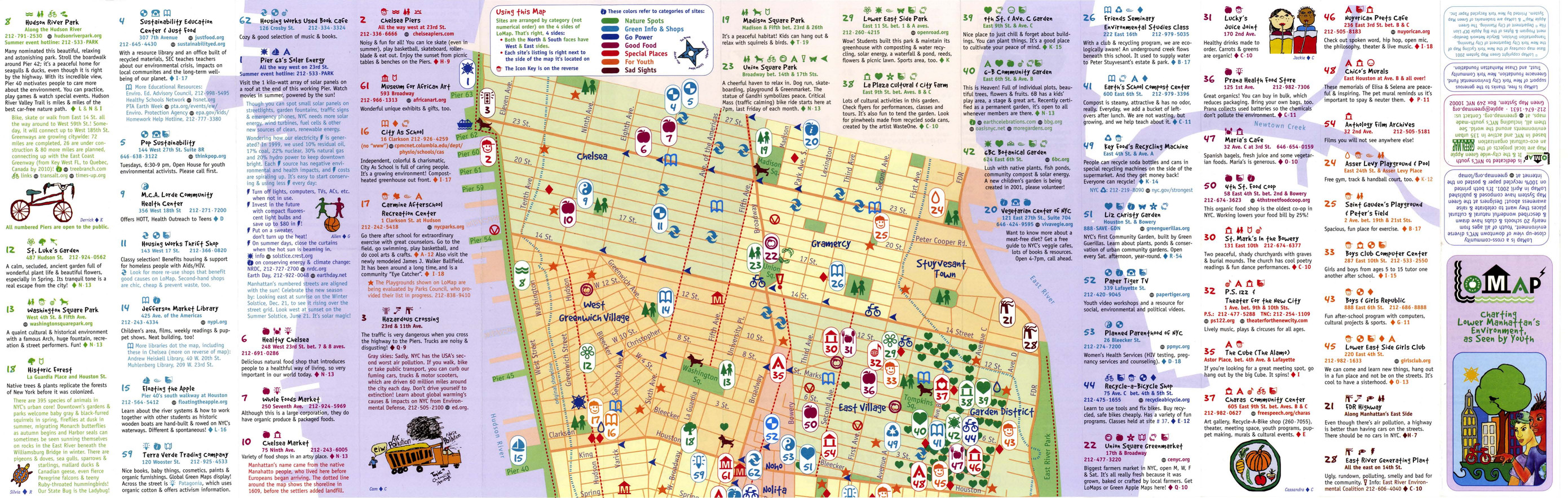
- Alternative Title
- LoMap: explore downtown's environment as guided by youth
- Subject
- Libraries, Public art, Farmers' markets, Community centers, Museums, Recycling (Waste, etc.), Air--Pollution, Local transit, Recreation centers, Thrift shops, Voluntarism, Culture, Animals, Parks, Recreation areas, Renewable energy sources, Community gardens, and Plants
- Creator
- Green Map System (Firm)
- Contributor
- Kline, Diana Signe, Ferguson, Beth, and Brawer, Wendy E.
- Publisher
- New York Recycled Paper Inc.
- Language
- eng
- Date created
- 2000
- Rights Statement
- In Copyright - Educational Use Permitted
- Resource Type
- Still Image
- Identifier
- Green Map System Number: US3
- Extent
- 1 map : colour ; 94 x 30 cm
- Geographic Coverage
- New York (State)--New York--Manhattan, New York (State), and United States
- Coordinates
- 40.78343, -73.96625, 40.71427, -74.00597, and 39.76, -98.5
- Chronological Coverage
- 2000
- Collection
- International Green Maps
- Provenance
- Digital files provided by Green Map System, New York, NY.
- Provider
- University of Victoria (B.C.). Library
- Genre
- maps (documents)
- Date Digitized
- 2007-06-11
- Technical Note
- Adobe PDF. Received in digital format. Metadata by PD and MT.
-

- Subject
- Trees, Sustainable buildings, Sewage disposal plants, Fair trade foods, Parks, Wetlands, Culture, Wildlife conservation, Museums, Community centers, Local transit, Open spaces, Environmental education, Renewable energy sources, Community gardens, Animals, Recycling (Waste, etc.), Public art, and Farmers' markets
- Creator
- City of Melbourne
- Contributor
- RMIT University. Centre for Design
- Publisher
- City of Melbourne
- Language
- eng
- Date created
- 2001
- Rights Statement
- In Copyright - Educational Use Permitted
- Resource Type
- Still Image
- Identifier
- Green Map System Number: AU2
- Extent
- 1 map : colour ; 68 x 62 cm
- Geographic Coverage
- Australia and Victoria--Melbourne
- Coordinates
- -25, 135 and -37.814, 144.96332
- Chronological Coverage
- 2001
- Collection
- International Green Maps
- Provenance
- Digital files provided by Green Map System, New York, NY.
- Provider
- University of Victoria (B.C.). Library
- Genre
- maps (documents)
- Date Digitized
- 2007-06-19
- Technical Note
- Adobe PDF. Received in digital format. Metadata by PD and MT.
-

- Alternative Title
- Sabin neighborhood greenmap: a Portland Greenmap pilot project sponsored by Nature's Northwest
- Subject
- Public art, Cycling, Libraries, Playgrounds, Community centers, Habitat (Ecology), Parks, Natural foods, Community gardens, Thrift shops, Forests and forestry, and Environmental education
- Creator
- Portland Greenmap
- Contributor
- King, Jason and Kausfamann, Cathy
- Publisher
- Portland Greenmap
- Language
- eng
- Date created
- 2001
- Rights Statement
- In Copyright - Educational Use Permitted
- Resource Type
- Still Image
- Identifier
- Green Map System Number: US38
- Extent
- 1 map : colour ; 27 x 43 cm
- Geographic Coverage
- Oregon--Portland and United States
- Coordinates
- 45.52345, -122.67621 and 39.76, -98.5
- Chronological Coverage
- 2001
- Collection
- International Green Maps
- Provenance
- Digital files provided by Green Map System, New York, NY.
- Provider
- University of Victoria (B.C.). Library
- Genre
- maps (documents)
- Date Digitized
- 2007-06-19
- Technical Note
- Adobe PDF. Received in digital format. Metadata by PD and MT.
-

- Alternative Title
- Victoria Falls municipal green map
- Subject
- Natural areas, Parks, Farmers' markets, Sustainable buildings, Deforestation, Waterfalls, Local transit, Forests and forestry, Soil erosion, Habitat (Ecology), Animals, Renewable energy sources, Plants, and Cycling
- Creator
- Victoria Falls Environmental Capacity and Master Plan Project
- Contributor
- Victoria Falls Environmental Capacity and Master Plan Project
- Publisher
- Victoria Falls Environmental Capacity and Master Plan Project
- Language
- eng
- Date created
- 2001
- Rights Statement
- In Copyright - Educational Use Permitted
- Resource Type
- Still Image
- Identifier
- Green Map System Number: AF5
- Extent
- 1 map : colour ; 42 x 27 cm
- Geographic Coverage
- Africa--Victoria Falls and Zimbabwe--Victoria Falls
- Coordinates
- -17.93285, 25.83066
- Chronological Coverage
- 2000
- Collection
- International Green Maps
- Provenance
- Digital files provided by Green Map System, New York, NY.
- Provider
- University of Victoria (B.C.). Library
- Genre
- maps (documents)
- Date Digitized
- 2007-06-19
- Technical Note
- Adobe PDF. Received in digital format. Metadata by PD and MT.