Search
Search Constraints
Start Over Filtering by: Genre maps (documents) ✖ Remove constraint Genre: maps (documents) Subject Plants ✖ Remove constraint Subject: Plants
1 - 8 of 8
Number of results to display per page
Search Results
-

- Alternative Title
- Philadelphus Green Map, Wakulla Green Map, Red Banks Green Map, Maxton Green Map, Pembroke Green Map, Alma Green Map, and Red Springs Green Map
- Subject
- Recreation areas, Recycling (Waste, etc.), Farmers' markets, Parks, Community centers, Gardens, Cycling, Sewage, Plants, Water treatment plants--Waste disposal, and Environmental education
- Creator
- Robeson County Green Map Project
- Contributor
- Robeson County Green Map Project
- Publisher
- Robeson County Green Map Project
- Language
- eng
- Rights Statement
- In Copyright - Educational Use Permitted
- Resource Type
- Text
- Identifier
- Green Map System Number: US85
- Extent
- 1 map : colour ; 35 x 21 cm
- Geographic Coverage
- North Carolina--Pembroke, United States, North Carolina--Alma, North Carolina--Red Banks, North Carolina--Robeson County, North Carolina--Wakulla, North Carolina--Maxton, North Carolina--Philadelphus, and North Carolina--Red Springs
- Coordinates
- 34.70294, -79.25087, 34.75905, -79.17142, 34.73516, -79.34893, 34.72377, -79.31254, 34.64009, -79.10353, 34.68016, -79.19504, 34.79266, -79.25504, 39.76, -98.5, and 34.81516, -79.18309
- Collection
- International Green Maps
- Provenance
- Digital files provided by Green Map System, New York, NY.
- Provider
- University of Victoria (B.C.). Library
- Genre
- maps (documents)
- Date Digitized
- 2004-05-06
- Technical Note
- 200 dpi TIFF. Received in digital format. Metadata by PD and MT.
-

- Subject
- Hudson's Bay Company, College buildings, College campuses, Pioneers, Indigenous peoples, Military bases, Gordon Head Army Camp (Victoria, B.C.), Colonists, Land use, History, Military training camps, Ecology, Natural history, Plants, World War (1939-1945), Agriculture, Exhibitions, Land settlement, Universities and colleges, and Families
- Creator
- Contributor
- Heffernan, Claire
- Location
- Language
- eng
- Date created
- 1992
- Rights Statement
- Public Domain Mark 1.0
- Resource Type
- Still Image
- Extent
- 12 panels
- Geographic Coverage
- British Columbia--Saanich--Gordon Head
- Coordinates
- 48.46325, -123.312180
- Additional Physical Characteristics
- 12 exhibit panels divided into their left and right sides resulting in 24 panels. Panels on the right are 60.5 x 81 cm and panels on the left are 122 x 81 cm.
- Physical Repository
- University of Victoria (B.C.). Library
- Collection
- Researcher Contributions
- Provider
- University of Victoria (B.C.). Library
- Genre
- color photographs, posters, maps (documents), black-and-white photographs, photographs, aerial photographs, and historical maps
- Fonds Title
- Gordon Head Exhibit Project fonds
- Fonds Identifier
- AR283
- Is Referenced By
- Archival finding aid: https://uvic2.coppul.archivematica.org/gordon-head-exhibit-project-fonds
- Date Digitized
- 2023-02
- Technical Note
- 600 DPI tiffs. Scanned on the Betterlight/TTI (1/20; 283; copy4 tone; camera at 1200) by PD. Metadata by KD.
-
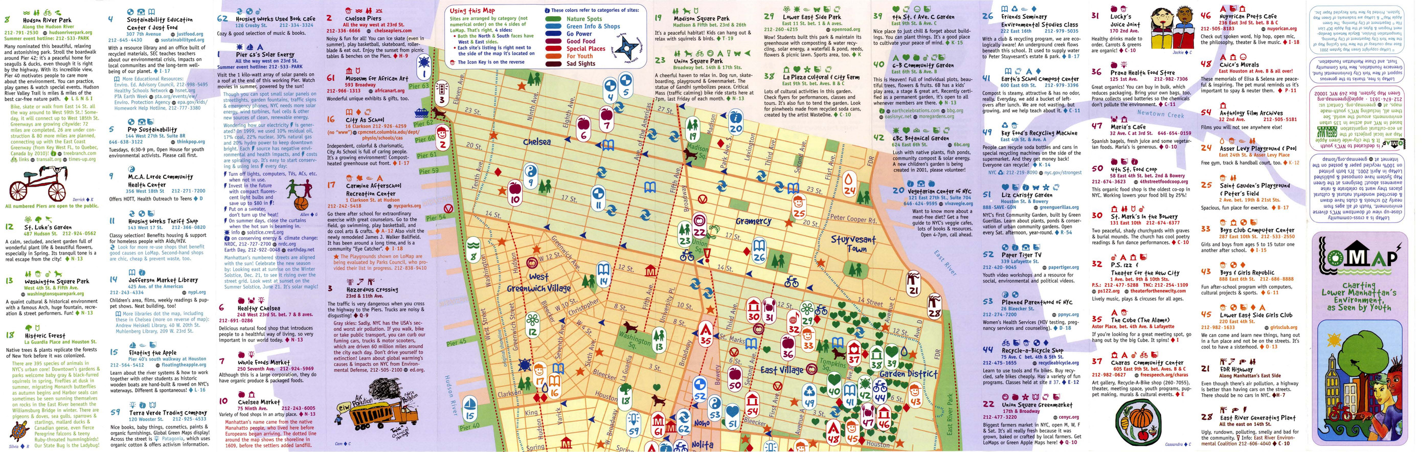
- Alternative Title
- LoMap: explore downtown's environment as guided by youth
- Subject
- Libraries, Public art, Farmers' markets, Community centers, Museums, Recycling (Waste, etc.), Air--Pollution, Local transit, Recreation centers, Thrift shops, Voluntarism, Culture, Animals, Parks, Recreation areas, Renewable energy sources, Community gardens, and Plants
- Creator
- Green Map System (Firm)
- Contributor
- Kline, Diana Signe, Ferguson, Beth, and Brawer, Wendy E.
- Publisher
- New York Recycled Paper Inc.
- Language
- eng
- Date created
- 2000
- Rights Statement
- In Copyright - Educational Use Permitted
- Resource Type
- Still Image
- Identifier
- Green Map System Number: US3
- Extent
- 1 map : colour ; 94 x 30 cm
- Geographic Coverage
- New York (State)--New York--Manhattan, New York (State), and United States
- Coordinates
- 40.78343, -73.96625, 40.71427, -74.00597, and 39.76, -98.5
- Chronological Coverage
- 2000
- Collection
- International Green Maps
- Provenance
- Digital files provided by Green Map System, New York, NY.
- Provider
- University of Victoria (B.C.). Library
- Genre
- maps (documents)
- Date Digitized
- 2007-06-11
- Technical Note
- Adobe PDF. Received in digital format. Metadata by PD and MT.
-

- Alternative Title
- Victoria Falls municipal green map
- Subject
- Natural areas, Parks, Farmers' markets, Sustainable buildings, Deforestation, Waterfalls, Local transit, Forests and forestry, Soil erosion, Habitat (Ecology), Animals, Renewable energy sources, Plants, and Cycling
- Creator
- Victoria Falls Environmental Capacity and Master Plan Project
- Contributor
- Victoria Falls Environmental Capacity and Master Plan Project
- Publisher
- Victoria Falls Environmental Capacity and Master Plan Project
- Language
- eng
- Date created
- 2001
- Rights Statement
- In Copyright - Educational Use Permitted
- Resource Type
- Still Image
- Identifier
- Green Map System Number: AF5
- Extent
- 1 map : colour ; 42 x 27 cm
- Geographic Coverage
- Africa--Victoria Falls and Zimbabwe--Victoria Falls
- Coordinates
- -17.93285, 25.83066
- Chronological Coverage
- 2000
- Collection
- International Green Maps
- Provenance
- Digital files provided by Green Map System, New York, NY.
- Provider
- University of Victoria (B.C.). Library
- Genre
- maps (documents)
- Date Digitized
- 2007-06-19
- Technical Note
- Adobe PDF. Received in digital format. Metadata by PD and MT.
-

- Subject
- Plants, Parks, Outdoor recreation, Trees, Community centers, Recycling (Waste, etc.), Museums, and Recreation areas
- Creator
- Nishinomiya-Kofu Senior High School
- Language
- jpn
- Date created
- 2002
- Rights Statement
- In Copyright - Educational Use Permitted
- Resource Type
- Still Image
- Identifier
- Green Map System Number: JP24
- Extent
- 1 map : colour ; 41 x 29 cm
- Geographic Coverage
- Japan--Nishinomiya-shi
- Coordinates
- 34.78194, 135.30247
- Chronological Coverage
- 2002
- Collection
- International Green Maps
- Provenance
- Digital files provided by Green Map System, New York, NY.
- Provider
- University of Victoria (B.C.). Library
- Genre
- maps (documents)
- Date Digitized
- 2007-06-07
- Technical Note
- Adobe PDF. Received in digital format. Metadata by PD and MT.
-

- Subject
- Community gardens, Public art, Plants, and Archaeology
- Publisher
- Tamagawa Tri-Area Green Map
- Language
- jpn
- Date created
- 2002
- Rights Statement
- In Copyright - Educational Use Permitted
- Resource Type
- Text
- Identifier
- Green Map System Number: JP28
- Extent
- 1 map : colour ; 59 x 42 cm
- Geographic Coverage
- Japan--Tokyo and Japan--Tama River (Yamanashi-ken-Tokyo)
- Coordinates
- 35.6895, 139.69171 and 35.5218, 139.7983
- Chronological Coverage
- 2002
- Collection
- International Green Maps
- Provenance
- Digital files provided by Green Map System, New York, NY.
- Provider
- University of Victoria (B.C.). Library
- Genre
- maps (documents)
- Date Digitized
- 2019-12-11
- Technical Note
- Adobe PDF. Received in digital format. Metadata by PD and MT.
- Keyword in Context
- E-3 ••rn-tt*■ (-IJ'?7) .:A.t,1Jtl,f�i!.ll'7>J:t:a,9�lll1.i -+t?7'7>1E'7>�1ilt:tr-?,t �f$ff ?'t� ,e:-?� 1:a a oti.-?>. E-3 ••111aaie•11�H:t 11t83*1X:Ell1·5·1 tel:03-3701- 1679 iiiII, ,e,:..i;-?>Jt.!1'7>r =:J-�it>lf�tl{l l:'.li• m:!au t:$l,i2,&'.>1!1'f_H,. C-t ll!iR,t•J;...
-

- Alternative Title
- Green World of Prince Alexander, The
- Subject
- Trees, Wildlife conservation, Recreation areas, Nature conservation, Plants, and Parks
- Creator
- Roeloffzen, Anton and van Essen, Jessica
- Contributor
- Lievaart Vormgeving & Communicatie (Firm)
- Publisher
- Centrum voor Natuur en Milieueducatie 'De Blijde Wei'
- Language
- nld
- Date created
- 2003
- Rights Statement
- In Copyright - Educational Use Permitted
- Resource Type
- Still Image
- Identifier
- Green Map System Number: EU7
- Extent
- 1 map : colour ; 49 x 69 cm
- Geographic Coverage
- Netherlands--Rotterdam
- Coordinates
- 51.9225, 4.47917
- Chronological Coverage
- 2003
- Collection
- International Green Maps
- Provenance
- Digital files provided by Green Map System, New York, NY.
- Provider
- University of Victoria (B.C.). Library
- Genre
- maps (documents)
- Date Digitized
- 2018-03-26
- Technical Note
- 200 dpi TIFF. Received in digital format. Metadata by PD and MT.
- Keyword in Context
- I o.p f ~- • Parken, bijzondere bomen en tuinen • Fiets- en wandelroutes Gezien in Prins Alexander Ekster Lepelaar Krooneend Groene specht Putter Torenvalk Groot koolwitje Ringslang ------- \._ \ \ " -~· \ ---------- I I I ------/ --- \ ...
-

- Alternative Title
- Kenoh Green Map, Tsubame-Sanjo, Nigata Pref. and Niigata prefecture Kenoh Green Map
- Subject
- Neighborhoods, Museums, Outdoor recreation, Recreation areas, Plants, Trees, Wildlife conservation, and Parks
- Creator
- Yokoki, Hiroyuki
- Publisher
- Tsubame-Sanjo Junior Chamber of Commerce
- Language
- jpn
- Date created
- 2003
- Rights Statement
- In Copyright - Educational Use Permitted
- Resource Type
- Text
- Identifier
- Green Map System Number: JP32
- Extent
- 1 map : colour ; 58 x 41 cm
- Geographic Coverage
- Japan--Tagami-machi, Japan--Teradomari-machi, Japan--Sanjō-shi, Japan--Niigata-ken, and Japan--Tsubame-shi
- Coordinates
- 37.61667, 138.95, 37.69828, 139.06947, 37.52343, 138.91748, 37.6645, 138.92518, and 37.58333, 138.73333
- Chronological Coverage
- 2003
- Collection
- International Green Maps
- Provenance
- Digital files provided by Green Map System, New York, NY.
- Provider
- University of Victoria (B.C.). Library
- Genre
- maps (documents)
- Date Digitized
- 2004-06-23
- Technical Note
- 300 dpi TIFF. Born digital resource. Metadata by PD and MT.