Search Constraints
Filtering by:
Genre
maps (documents)
Remove constraint Genre: maps (documents)
Subject
Watersheds
Remove constraint Subject: Watersheds
1 - 5 of 5
Number of results to display per page
Search Results
-
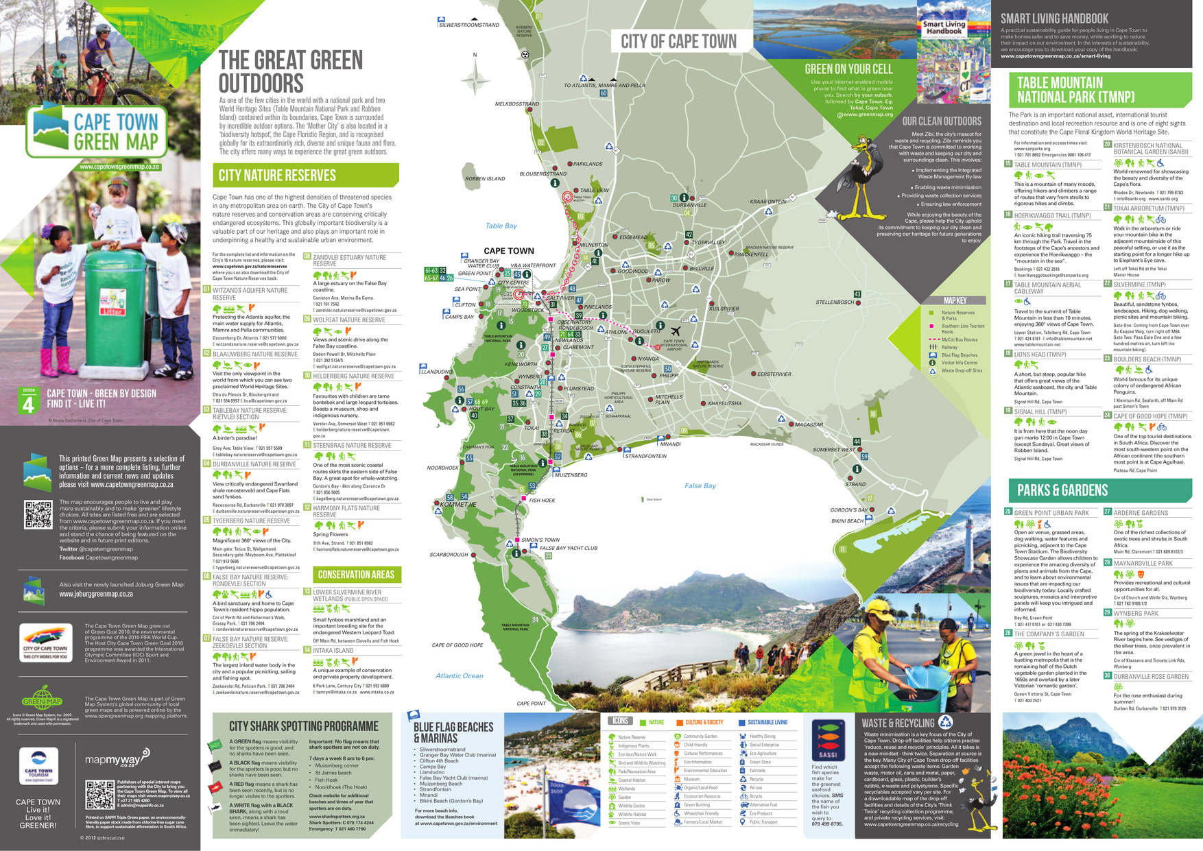
 Alternative Title:The great green outdoorsSubject:Wetland conservation, Outdoor recreation, Watersheds, Natural areas, and ParksCreator:Publisher:A&C MapsLanguage:engDate Created:2013Rights Statement:Resource Type:TextIdentifier:Green Map System Number: AF1Extent:1 map : colourEdition:4th editionGeographic Coverage:South Africa--Cape TownCoordinates:-33.92584, 18.42322Chronological Coverage:2013Collection:International Green MapsProvenance:Digital files provided by Green Map System, New York, NY.Provider:University of Victoria (B.C.). LibraryGenre:maps (documents)Date Digitized:2013-01-11Technical Note:Adobe PDF. Received in digital format. Metadata by PD and MT.Keyword in Context:Transcript available
This printed Green Map presents a selection of options – for a more complete listing, further information and current news and updates please visit www.capetowngreenmap.co.za Printed on SAPPI Triple Green paper, an environmentally- friendly paper stock made from chlor... -
 Alternative Title:Niagara greenmap: forests, hiking, wetlands, wildlife areasSubject:Forests and forestry, Art museums, Tourist information centers, Watersheds, Museums, Local transit, Farmers' markets, Parks, Hazardous waste sites, Environmental education, Natural areas, Trails, Wetlands, City halls, Recycling (Waste, etc.), Renewable energy sources, Theater, and GardensCreator:Publisher:Regional NiagaraLanguage:engDate Created:2003?Rights Statement:Resource Type:Still ImageIdentifier:Green Map System Number: CA17Extent:1 map : colour ; 87 x 57 cmGeographic Coverage:Ontario--Niagara (Regional municipality)Coordinates:43.21682, -79.11627Collection:International Green MapsProvenance:Digital files provided by Green Map System, New York, NY.Provider:University of Victoria (B.C.). LibraryGenre:maps (documents)Date Digitized:2004-06-22/2004-06-23Technical Note:300 dpi TIFF. Received in digital format. Metadata by PD and MT.
 -
 Subject:Reservoirs, Water-supply, and WatershedsContributor:Location:Language:engDate Created:approximately 1852Rights Statement:Resource Type:Still ImageIdentifier:Ruggles Number: 321A and G1/258oExtent:1 sheet ; 73 x 54 cmGeographic Coverage:British Columbia--Esquimalt, British Columbia--Vancouver Island, and British Columbia--VictoriaCoordinates:48.43569, -123.41174, 48.4359, -123.35155, and 49.75152, -126.48958Additional Physical Characteristics:1:63,360Physical Repository:Hudson's Bay Company. ArchivesCollection:Early B.C. Maps from the Hudson's Bay Company ArchivesProvider:University of Victoria (B.C.). LibraryGenre:maps (documents) and historical mapsDate Digitized:2013-05-10Transcript:1 inch:1 mile
 -
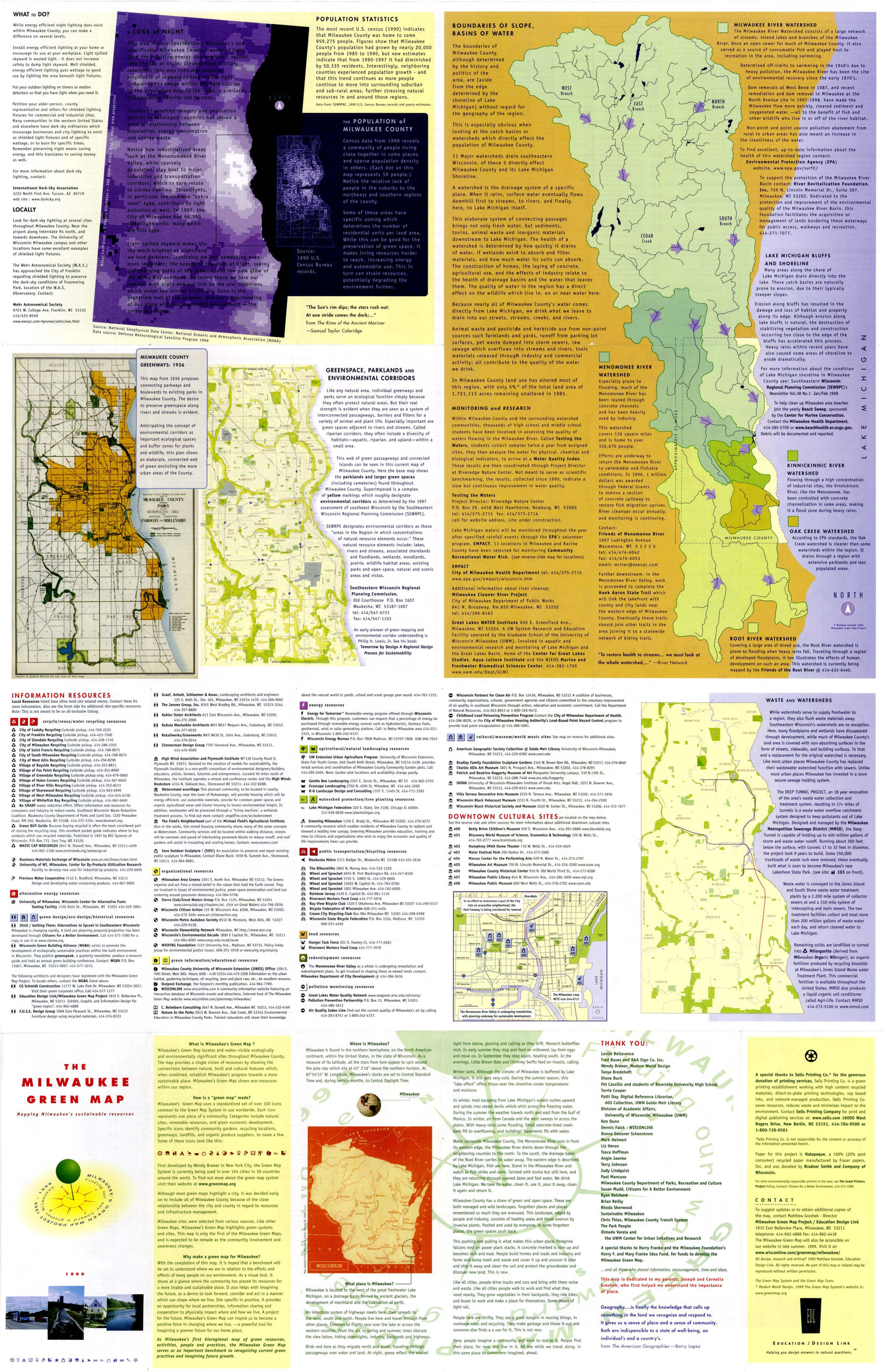
 Subject:Renewable energy sources, Watersheds, Culture, Thrift shops, Environmental education, Farmers' markets, Cycling, Natural areas, Wildlife conservation, Community gardens, Population--Statistics, Parks, Fair trade foods, Open spaces, Local transit, Animals, and Recycling (Waste, etc.)Creator:Contributor:Groshek, MatthewPublisher:Sells Printing Co.Language:engDate Created:1999Rights Statement:Resource Type:Still ImageIdentifier:Green Map System Number: US52Extent:1 map : colour ; 86 x 55 cmGeographic Coverage:Wisconsin--Milwaukee and United StatesCoordinates:39.76, -98.5 and 43.0389, -87.90647Chronological Coverage:1999Collection:International Green MapsProvenance:Digital files provided by Green Map System, New York, NY.Provider:University of Victoria (B.C.). LibraryGenre:maps (documents)Date Digitized:2007-06-11Technical Note:Adobe PDF. Received in digital format. Metadata by PD and MT.
 -
 Alternative Title:Santa Monica and Ballona watershed green mapSubject:Environmental conditions, Watershed management, and WatershedsCreator:Contributor:Duvivier, IsabellePublisher:Ventura GraphicsLanguage:engDate Created:2001Rights Statement:Resource Type:Still ImageIdentifier:Green Map System Number: US22Extent:1 map : colour ; 80 x 43 cmGeographic Coverage:United States, California--Ballona Wetlands, and California--Santa MonicaCoordinates:33.96557, -118.44508, 39.76, -98.5, and 34.01949, -118.49138Chronological Coverage:2000Collection:International Green MapsProvenance:Digital files provided by Green Map System, New York, NY.Provider:University of Victoria (B.C.). LibraryGenre:maps (documents)Date Digitized:2007-06-19Technical Note:Adobe PDF. Received in digital format. Metadata by PD and MT.