Search
Search Constraints
Start Over Filtering by: Genre maps (documents) ✖ Remove constraint Genre: maps (documents)
Number of results to display per page
Search Results
-
- Subject
- Indigenous peoples, Land titles, Land titles--Maps, Indian reservations, Land cover, and Land use
- Creator
- Surveyor General of British Columbia
- Contributor
- McVittie, Thomas Thane, 1855-1918
- Language
- eng
- Rights Statement
- No Copyright - Non-Commercial Use Only
- Resource Type
- Still Image
- Identifier
- LTSA Inventory No.: LTSA6170, LTSA SGD Microfilm Image Number: 106399, Plan Number: 08TR-IR (Kootenay), Kootenay 8, and Plan Barcode: Z0366387
- Extent
- 1 sheet
- Geographic Coverage
- British Columbia--Central Kootenay, North America--Kootenai River, and British Columbia--Goat River
- Coordinates
- 49.91655, -117.50222 and 49.08317, -116.56881
- Additional Physical Characteristics
- Scale: 1 inch = 40 chains
- Physical Repository
- Land Title and Survey Authority of British Columbia
- Collection
- Land Title and Survey Authority of British Columbia: Indian Reserve Maps
- Provider
- University of Victoria (B.C.). Library
- Genre
- maps (documents), historical maps, and land surveys
- Technical Note
- Cataloguing metadata: Provided by the LTSA and adapted by University of Victoria Libraries to their requirements.
-
- Language
- eng
- Rights Statement
- No Copyright - Contractual restrictions
- Resource Type
- Still Image
- Identifier
- G1/258x_sheet_01
- Extent
- 1 sheet
- Geographic Coverage
- British Columbia--Sooke and British Columbia--Victoria Metropolitan Area
- Coordinates
- 48.37463, -123.72762
- Physical Repository
- Hudson's Bay Company. Archives
- Collection
- Early B.C. Maps from the Hudson's Bay Company Archives
- Provider
- University of Victoria (B.C.). Library
- Genre
- maps (documents) and historical maps
- Date Digitized
- 2013-05-10
-
- Subject
- Indigenous peoples
- Language
- eng
- Rights Statement
- No Copyright - Contractual restrictions
- Resource Type
- Still Image
- Identifier
- G1/258x_sheet_02
- Extent
- 1 sheet
- Geographic Coverage
- British Columbia--Sooke and British Columbia--Victoria Metropolitan Area
- Coordinates
- 48.37463, -123.72762
- Physical Repository
- Hudson's Bay Company. Archives
- Collection
- Early B.C. Maps from the Hudson's Bay Company Archives
- Provider
- University of Victoria (B.C.). Library
- Genre
- maps (documents) and historical maps
- Date Digitized
- 2013-05-10
-
- Subject
- Land titles--Maps, Indian reservations, Land use, Indigenous peoples, Land cover, and Land titles
- Creator
- Surveyor General of British Columbia
- Contributor
- Green, Henry Ashdown, 1840-1927
- Language
- eng
- Rights Statement
- No Copyright - Non-Commercial Use Only
- Resource Type
- Still Image
- Identifier
- LTSA Inventory No.: LTSA6178, Plan Number: 36TR-1A-IR (two sheets), Plan Barcode: Z0366618, and LTSA SGD Microfilm Image Number: 106593
- Extent
- 1 sheet
- Geographic Coverage
- British Columbia--Metlakatla, British Columbia--Prince Rupert Harbour, Pacific Ocean--Duncan Bay, British Columbia--Finlayson Island, and British Columbia--Skeena-Queen Charlotte
- Coordinates
- 54.35436, -130.47552, 54.54113, -130.47235, 54.31993, -130.33836, and 54.33731, -130.44404
- Additional Physical Characteristics
- Scale: 1 inch = 40 chains
- Physical Repository
- Land Title and Survey Authority of British Columbia
- Collection
- Land Title and Survey Authority of British Columbia: Indian Reserve Maps
- Provider
- University of Victoria (B.C.). Library
- Genre
- maps (documents), historical maps, and land surveys
- Technical Note
- Cataloguing metadata: Provided by the LTSA and adapted by University of Victoria Libraries to their requirements.
-
- Subject
- Real property
- Language
- eng
- Rights Statement
- No Copyright - Contractual restrictions
- Resource Type
- Still Image
- Identifier
- G1/254
- Extent
- 1 sheet
- Geographic Coverage
- British Columbia--Oak Bay, British Columbia--Saanich, and British Columbia--Victoria
- Coordinates
- 48.4359, -123.35155 and 48.54964, -123.36931
- Physical Repository
- Hudson's Bay Company. Archives
- Collection
- Early B.C. Maps from the Hudson's Bay Company Archives
- Provider
- University of Victoria (B.C.). Library
- Genre
- maps (documents) and historical maps
- Date Digitized
- 2013-05-10
-
- Alternative Title
- Philadelphus Green Map, Wakulla Green Map, Red Banks Green Map, Maxton Green Map, Pembroke Green Map, Alma Green Map, and Red Springs Green Map
- Subject
- Recreation areas, Recycling (Waste, etc.), Farmers' markets, Parks, Community centers, Gardens, Cycling, Sewage, Plants, Water treatment plants--Waste disposal, and Environmental education
- Creator
- Robeson County Green Map Project
- Contributor
- Robeson County Green Map Project
- Publisher
- Robeson County Green Map Project
- Language
- eng
- Rights Statement
- In Copyright - Educational Use Permitted
- Resource Type
- Text
- Identifier
- Green Map System Number: US85
- Extent
- 1 map : colour ; 35 x 21 cm
- Geographic Coverage
- North Carolina--Pembroke, United States, North Carolina--Alma, North Carolina--Red Banks, North Carolina--Robeson County, North Carolina--Wakulla, North Carolina--Maxton, North Carolina--Philadelphus, and North Carolina--Red Springs
- Coordinates
- 34.70294, -79.25087, 34.75905, -79.17142, 34.73516, -79.34893, 34.72377, -79.31254, 34.64009, -79.10353, 34.68016, -79.19504, 34.79266, -79.25504, 39.76, -98.5, and 34.81516, -79.18309
- Collection
- International Green Maps
- Provenance
- Digital files provided by Green Map System, New York, NY.
- Provider
- University of Victoria (B.C.). Library
- Genre
- maps (documents)
- Date Digitized
- 2004-05-06
- Technical Note
- 200 dpi TIFF. Received in digital format. Metadata by PD and MT.
-
- Subject
- Real property
- Language
- eng
- Rights Statement
- No Copyright - Contractual restrictions
- Resource Type
- Still Image
- Identifier
- G1/262
- Extent
- 1 sheet
- Geographic Coverage
- British Columbia--Victoria and Fort Victoria
- Coordinates
- 48.4359, -123.35155
- Physical Repository
- Hudson's Bay Company. Archives
- Collection
- Early B.C. Maps from the Hudson's Bay Company Archives
- Provider
- University of Victoria (B.C.). Library
- Genre
- maps (documents) and historical maps
- Date Digitized
- 2013-05-10
-
- Language
- eng
- Rights Statement
- No Copyright - Contractual restrictions
- Resource Type
- Still Image
- Identifier
- G1/258a
- Extent
- 1 sheet
- Geographic Coverage
- British Columbia--Victoria
- Coordinates
- 48.4359, -123.35155
- Additional Physical Characteristics
- 1:10,560
- Physical Repository
- Hudson's Bay Company. Archives
- Collection
- Early B.C. Maps from the Hudson's Bay Company Archives
- Provider
- University of Victoria (B.C.). Library
- Genre
- maps (documents) and historical maps
- Date Digitized
- 2013-05-10
- Transcript
- drawn with reference to Levels only, which are slightly exaggerated: the figures are the heights in feet and decimals of the xs beside them, above the Sill of the Western gate of Fort, which Sill is about ft above High Water mark and represents the general Level at...
-
- Language
- eng
- Rights Statement
- No Copyright - Contractual restrictions
- Resource Type
- Still Image
- Identifier
- H1/1 fo. 6
- Extent
- 1 sheet
- Geographic Coverage
- British Columbia--Saanich and British Columbia--Victoria
- Coordinates
- 48.54964, -123.36931 and 48.4359, -123.35155
- Additional Physical Characteristics
- 1:10,560
- Physical Repository
- Hudson's Bay Company. Archives
- Collection
- Early B.C. Maps from the Hudson's Bay Company Archives
- Provider
- University of Victoria (B.C.). Library
- Genre
- historical maps and maps (documents)
- Date Digitized
- 2013-05-10
- Transcript
- 6 inches:1 mile
-
Victoria Fire Insurance Plans
User Collection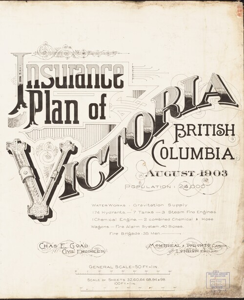 1Collections5Works
- Description:
- The Fire Insurance Plans (FIPs) from 1885 to 1916 are undoubtedly the best maps of Victoria for the period. Created by Charles E. Goad and Company to assist insurance underwriters in determining fire insurance risk these coloured maps show the developing...
- Subject
- Local History and Architecture
- Location
- Victoria, British Columbia, Canada
- Resource Type
- Collection
- Genre
- maps (documents) and historical maps