Search
Search Results
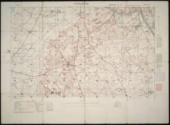
- Alternative Title:
- Trench Map. Wytschaete. 28 S.W. 2. Edition 3. D. and sh. 28SW2 1916 28 S.W. 2: Wytschaete. Ed. 3.D. 1916.
- Subject:
- Grids (Cartography), Military maps, World War (1914-1918), Intrenchments, and Military history
- Creator:
- Great Britain. War Office. General Staff. Geographical Section
- Language:
- eng
- Date Created:
- 1916
- Rights Statement:
- No Copyright - Non-Commercial Use Only
- Resource Type:
- Still Image
- Identifier:
- Geographical Section, General Staff No. 3062
- Extent:
- 1 sheet ; 68 x 93 cm
- Edition:
- Edition 3.D.
- Geographic Coverage:
- Belgium--Wytschaete
- Coordinates:
- 50.78632, 2.88369
- Additional Physical Characteristics:
- Scale: 1:10,000 and "Property of A.G. Mitchell" written in black in on the verso.
- Physical Repository:
- University of Victoria (B.C.). Library
- Collection:
- Military History Collection
- Provenance:
- Donor: A.G. Mitchell, Esq.
- Provider:
- University of Victoria (B.C.). Library
- Genre:
- historical maps, maps (documents), and military maps
- Archival Item Identifier:
- Accession Number: 2018-042; File: MM35 - Trench Maps; Item: sh. 28SW2 1916 - Wytschaete
- Fonds Title:
- Military maps collection
- Fonds Identifier:
- SC122
- Is Referenced By:
- Archival Finding Aid: https://search.archives.uvic.ca/military-maps-collection
- Date Digitized:
- 2024-03
- Technical Note:
- Scanned on Betterlight/TTI (1/15; 283; copy4 tone; camera height 1000) by PD. Metadata by KD.