Search
Search Results
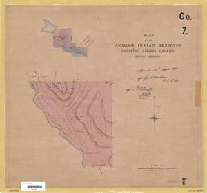
- Alternative Title:
- Plan of the Anaham Indian Reserves Chilcotin, Cariboo District. British Columbia.
- Subject:
- Indian reservations, Land titles--Maps, Land titles, Land cover, Indigenous peoples, and Land use
- Creator:
- Surveyor General of British Columbia
- Contributor:
- Skinner, Ernest Meeson, 1847-1918
- Language:
- eng
- Date Created:
- 1894
- Rights Statement:
- No Copyright - Non-Commercial Use Only
- Resource Type:
- Still Image
- Identifier:
- LTSA Inventory No.: LTSA6166, Plan Barcode: Z0366261, Cariboo 7, LTSA SGD Microfilm Image Number: 106293, and Plan Number: 07TR-IR (Cariboo)
- Extent:
- 1 sheet
- Geographic Coverage:
- British Columbia--Anahim Creek, British Columbia--Chilcotin River, and British Columbia--Cariboo Regional District
- Coordinates:
- 52.01652, -123.2029, 52.33313, -123.16961, and 51.73311, -122.4028
- Additional Physical Characteristics:
- Scale: 1 inch = 40 chains
- Physical Repository:
- Land Title and Survey Authority of British Columbia
- Collection:
- Land Title and Survey Authority of British Columbia: Indian Reserve Maps
- Provider:
- University of Victoria (B.C.). Library
- Genre:
- maps (documents), land surveys, and historical maps
- Technical Note:
- Cataloguing metadata: Provided by the LTSA and adapted by University of Victoria Libraries to their requirements.