Search
Search Results
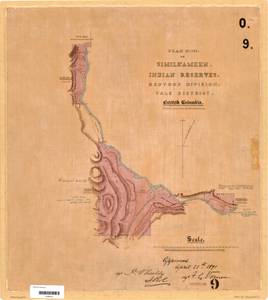
- Alternative Title:
- Plan No. 3 of Similkameen Indian Reserves, Osoyoos Division, Yale District, British Columbia
- Subject:
- Burial, Land cover, Indian reservations, Indigenous peoples, Land titles, Land use, and Land titles--Maps
- Creator:
- Surveyor General of British Columbia
- Contributor:
- Jemmett, William Sugden, Captain, 1835-1922
- Language:
- eng
- Date Created:
- 1889 to 1891
- Rights Statement:
- No Copyright - Non-Commercial Use Only
- Resource Type:
- Still Image
- Identifier:
- LTSA Inventory No.: LTSA6173, Osoyoos 9, LTSA SGD Microfilm Image Number: 106454, Plan Barcode: Z0366453, and Plan Number: 09TR-IR (Osoyoos)
- Extent:
- 1 sheet
- Geographic Coverage:
- North America--Similkameen River, British Columbia--Ashnola River, and British Columbia--Okanagan-Similkameen
- Coordinates:
- 49.21645, -120.00242, 49.22511, -119.97336, and 49.21646, -119.90241
- Additional Physical Characteristics:
- Scale: 1 inch = 40 chains
- Physical Repository:
- Land Title and Survey Authority of British Columbia
- Collection:
- Land Title and Survey Authority of British Columbia: Indian Reserve Maps
- Provider:
- University of Victoria (B.C.). Library
- Genre:
- maps (documents), land surveys, and historical maps
- Technical Note:
- Cataloguing metadata: Provided by the LTSA and adapted by University of Victoria Libraries to their requirements.

- Alternative Title:
- Plan No. IV of the Similkameen Indian Reserves, Osoyoos Divsion, Yale District, British Columbia
- Subject:
- Land titles, Land cover, Land use, Indigenous peoples, Indian reservations, and Land titles--Maps
- Creator:
- Surveyor General of British Columbia
- Contributor:
- Skinner, Ernest Meeson, 1847-1918
- Language:
- eng
- Date Created:
- 1894 to 1895
- Rights Statement:
- No Copyright - Non-Commercial Use Only
- Resource Type:
- Still Image
- Identifier:
- LTSA Inventory No.: LTSA6173, LTSA SGD Microfilm Image Number: 106455, Osoyoos 10, Plan Number: 10TR-IR (Osoyoos), and Plan Barcode: Z0366454
- Extent:
- 1 sheet
- Geographic Coverage:
- British Columbia--Ashnola River, North America--Similkameen River, and British Columbia--Okanagan-Similkameen
- Coordinates:
- 49.21646, -119.90241, 49.22511, -119.97336, and 49.21645, -120.00242
- Additional Physical Characteristics:
- Scale: 1 inch = 40 chains
- Physical Repository:
- Land Title and Survey Authority of British Columbia
- Collection:
- Land Title and Survey Authority of British Columbia: Indian Reserve Maps
- Provider:
- University of Victoria (B.C.). Library
- Genre:
- historical maps, land surveys, and maps (documents)
- Technical Note:
- Cataloguing metadata: Provided by the LTSA and adapted by University of Victoria Libraries to their requirements.