Search
Search Results
- Alternative Title:
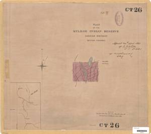
- Plan of the Kuldoe Indian Reserve Cassiar District British Columbia
- Subject:
- Land titles--Maps, Land titles, Indigenous peoples, Land cover, Land use, and Indian reservations
- Creator:
- Surveyor General of British Columbia
- Contributor:
- Skinner, Ernest Meeson, 1847-1918
- Language:
- eng
- Date Created:
- 1898
- Rights Statement:
- No Copyright - Non-Commercial Use Only
- Resource Type:
- Still Image
- Identifier:
- Plan Barcode: Z0366315, Plan Number: 26TR-IR (Coast), CT 26, LTSA SGD Microfilm Image Number: 106347, and LTSA Inventory No.: LTSA6168
- Extent:
- 1 sheet
- Geographic Coverage:
- British Columbia--Cassiar (District), British Columbia--Kuldo, and British Columbia--Skeena River
- Coordinates:
- 57.49965, -129.0038, 55.86667, -127.9, and 54.01523, -130.1128
- Additional Physical Characteristics:
- Scale: 1 inch = 20 chains
- Physical Repository:
- Land Title and Survey Authority of British Columbia
- Collection:
- Land Title and Survey Authority of British Columbia: Indian Reserve Maps
- Provider:
- University of Victoria (B.C.). Library
- Genre:
- historical maps, land surveys, and maps (documents)
- Technical Note:
- Cataloguing metadata: Provided by the LTSA and adapted by University of Victoria Libraries to their requirements.