Search
Search Results
- Alternative Title:
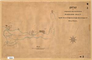
- Plan of Indian Reserves, Burrard Inlet, New Westminster District. British Columbia.
- Subject:
- Land cover, Land use, Indigenous peoples, Land titles--Maps, Land titles, and Indian reservations
- Creator:
- Surveyor General of British Columbia
- Contributor:
- Jemmett, William Sugden, Captain, 1835-1922
- Language:
- eng
- Date Created:
- 1880 to 1881
- Rights Statement:
- No Copyright - Non-Commercial Use Only
- Resource Type:
- Still Image
- Identifier:
- Plan Barcode: Z0366413, LTSA Inventory No.: LTSA6172, Plan Number: 02TR-IR (New Westminster), and LTSA SGD Microfilm Image Number: 106423
- Extent:
- 1 sheet
- Geographic Coverage:
- Pacific Ocean--Burrard Inlet, British Columbia--Metro Vancouver Regional District, British Columbia--North Shore, and British Columbia--False Creek
- Coordinates:
- 49.46637, -122.88594, 49.33296, -123.00264, and 49.26783, -123.12005
- Additional Physical Characteristics:
- Scale: 1 inch = 40 chains
- Physical Repository:
- Land Title and Survey Authority of British Columbia
- Collection:
- Land Title and Survey Authority of British Columbia: Indian Reserve Maps
- Provider:
- University of Victoria (B.C.). Library
- Genre:
- land surveys, historical maps, and maps (documents)
- Technical Note:
- Cataloguing metadata: Provided by the LTSA and adapted by University of Victoria Libraries to their requirements.