Search
Search Results
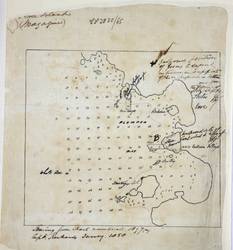
- Alternative Title:
- Plumper Bay, Thetis Cove, Esquimalt, Vancouver Island
- Subject:
- Nautical charts
- Creator:
- Richards, G. H. (George Henry)
- Contributor:
- Sharp, William H., Denman, Joseph, 1810-1874, and Coole, Trevenor P.
- Language:
- eng
- Date Created:
- 1858 to 1865
- Rights Statement:
- In Copyright - Educational Use Permitted
- Resource Type:
- Still Image
- Extent:
- 1 sheet
- Geographic Coverage:
- British Columbia--Esquimalt, British Columbia, British Columbia--Plumper Bay, and British Columbia--Thetis Cove
- Coordinates:
- 48.43569, -123.41174, 48.44403, -123.4345, 48.44896, -123.43414, and 53.99983, -125.0032
- Chronological Coverage:
- 1858/1865
- Additional Physical Characteristics:
- 1:7603
- Physical Repository:
- National Archives (Great Britain)
- Collection:
- Early BC Maps Collection
- Provenance:
- National Archives of the UK
- Provider:
- University of Victoria (B.C.). Library
- Genre:
- maps (documents) and historical maps
- Date Digitized:
- 2010-04-12
- Technical Note:
- Watermarks added to images by KM, JF, and CDW. Metadata by JTP April 28, 2010. and 600 dpi jpg