Search
Search Results
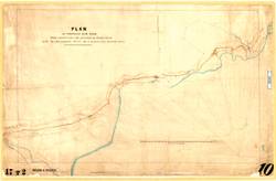
- Subject:
- Roads--Design and construction--Planning
- Creator:
- Green, F.W.
- Language:
- eng
- Date Created:
- 1865
- Rights Statement:
- No Copyright - Non-Commercial Use Only
- Resource Type:
- Still Image
- Identifier:
- LSV Number: 17T2RT, 106761, and Historical Map Society of B.C. Map Number: 2016
- Extent:
- 1 sheet ; 60 x 95 cm
- Geographic Coverage:
- British Columbia--Thompson River, British Columbia--Cache Creek, British Columbia--Savona, and British Columbia--Kamloops Lake
- Coordinates:
- 50.76647, -120.81925, 50.23304, -121.58589, 50.76647, -120.86926, and 50.81011, -121.3246
- Additional Physical Characteristics:
- Scale: 40 Chains to 1 Inch
- Physical Repository:
- Land Title and Survey Authority of British Columbia
- Collection:
- Land Title and Survey Authority of British Columbia: Early British Columbia Maps
- Provenance:
- Surveyor General of BC, Legal Surveys Vault
- Provider:
- University of Victoria (B.C.). Library
- Genre:
- historical maps and maps (documents)
- Date Digitized:
- 2011-09-30
- Technical Note:
- Cataloguing metadata: Provided by the LTSA and adapted by the University of Victoria Libraries to their requirements.