Search
Search Results
- Alternative Title:
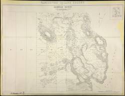
- Vancouver Island Colony. Sketch Maps of Districts
- Contributor:
- Cooke, A. C.
- Publisher:
- Great Britain -- War Office -- Topographical Depot
- Language:
- eng
- Date Created:
- 1859
- Rights Statement:
- In Copyright - Educational Use Permitted
- Resource Type:
- Still Image
- Identifier:
- Penfold Number: 568
- Extent:
- 1 sheet
- Geographic Coverage:
- British Columbia--Vancouver Island, British Columbia--Shawnigan Lake, and British Columbia--Shawnigan Region
- Coordinates:
- 49.65064, -125.44939 and 48.63167, -123.64028
- Additional Physical Characteristics:
- 1:15,840
- Physical Repository:
- National Archives (Great Britain)
- Collection:
- Early BC Maps Collection
- Provenance:
- National Archives of the UK
- Provider:
- University of Victoria (B.C.). Library
- Genre:
- maps (documents) and historical maps
- Archival Item Identifier:
- National Archives Number: CO700-BRITISH COLUMBIA7 (8)
- Date Digitized:
- 2010-04-12
- Technical Note:
- 600 dpi jpg and Watermarks added to images by KM, JF, and CDW. Metadata by JTP, April 21,2010.
- Language:
- eng
- Date Created:
- 1859
- Rights Statement:
- In Copyright - Educational Use Permitted
- Resource Type:
- Still Image
- Identifier:
- Penfold Number: 569
- Extent:
- 1 sheet
- Geographic Coverage:
- British Columbia--Vancouver Island, British Columbia--Shawnigan Lake, and British Columbia--Shawnigan Region
- Coordinates:
- 49.65064, -125.44939 and 48.63167, -123.64028
- Chronological Coverage:
- 1859
- Additional Physical Characteristics:
- 1:15,840
- Physical Repository:
- National Archives (Great Britain)
- Collection:
- Early BC Maps Collection
- Provenance:
- National Archives of the UK
- Provider:
- University of Victoria (B.C.). Library
- Genre:
- maps (documents) and historical maps
- Archival Item Identifier:
- National Archives Number: MPG1-243
- Date Digitized:
- 2010-04-22
- Technical Note:
- Watermarks added to images by KM, JF, and CDW. Metadata by JTP April 29, 2010. and 600 dpi jpg