Search
Search Results
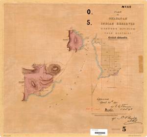
- Alternative Title:
- Plan of Okanagan Indian Reserve and Plan No. III of Okanagan Indian Reserves, Osoyoos Division Yale District, British Columbia
- Subject:
- Land use, Land titles, Indigenous peoples, Land cover, Indian reservations, and Land titles--Maps
- Creator:
- Surveyor General of British Columbia
- Contributor:
- Jemmett, William Sugden, Captain, 1835-1922
- Language:
- eng
- Date Created:
- 1891
- Rights Statement:
- No Copyright - Non-Commercial Use Only
- Resource Type:
- Still Image
- Identifier:
- Osoyoos 5, Plan Number: 05TR-IR (Osoyoos), Plan Barcode: Z0366447, LTSA SGD Microfilm Image Number: 106449, and LTSA Inventory No.: LTSA6173
- Extent:
- 1 sheet
- Geographic Coverage:
- British Columbia--West Kelowna, British Columbia--Okanagan Lake, British Columbia--Mission Creek, and British Columbia--Central Okanagan
- Coordinates:
- 49.84977, -119.46907, 49.84977, -119.48567, 49.84661, -119.51891, 49.84977, -119.60238, and 49.88307, -119.53568
- Additional Physical Characteristics:
- Scale: 1 inch = 40 chains
- Physical Repository:
- Land Title and Survey Authority of British Columbia
- Collection:
- Land Title and Survey Authority of British Columbia: Indian Reserve Maps
- Provider:
- University of Victoria (B.C.). Library
- Genre:
- land surveys, maps (documents), and historical maps
- Technical Note:
- Cataloguing metadata: Provided by the LTSA and adapted by University of Victoria Libraries to their requirements.