Search
Search Results
- Alternative Title:
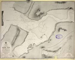
- North America, west coast. British Columbia. Nass Bay
- Subject:
- Boundaries and Nautical charts
- Creator:
- Pender, Daniel R.
- Contributor:
- Richards, G. H. (George Henry), Cameron, Donald Roderick, 1834-1905, Davies, Bryer & Co., Coghlan, James Edward, and Brodie, G. S.
- Publisher:
- Great Britain. Hydrographic Office.
- Language:
- eng
- Date Created:
- 1886
- Rights Statement:
- In Copyright - Educational Use Permitted
- Resource Type:
- Still Image
- Identifier:
- Penfold Number: 534
- Extent:
- 1 sheet
- Geographic Coverage:
- Canada, British Columbia, Nass River--British Columbia, and Alaska
- Coordinates:
- 64.00028, -150.00028, 53.99983, -125.0032, 54.96628, -129.91608, and 60.10867, -113.64258
- Chronological Coverage:
- 1868/1872
- Additional Physical Characteristics:
- 1:24,350
- Physical Repository:
- National Archives (Great Britain)
- Collection:
- Early BC Maps Collection
- Provenance:
- National Archives of the UK
- Provider:
- University of Victoria (B.C.). Library
- Genre:
- maps (documents) and historical maps
- Archival Item Identifier:
- National Archives Number: CO700-CANADA144 (17)
- Date Digitized:
- 2010-04-12
- Technical Note:
- 600 dpi jpg and Watermarks added to images by KM, JF, and CDW. Metadata by JTP April 28, 2010.