Search
Search Results
- Alternative Title:
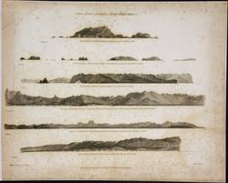
- Voyage of discovery to the North Pacific Ocean, and round the world
- Subject:
- Vancouver, George, 1757-1798 and Coasts
- Creator:
- Alexander, William, 1767-1816
- Contributor:
- Vancouver, George, 1757-1798, Humphrys, Henry, -1799, Heddington, Thomas, 1775 or 1776-1860, Sykes, John, 1770 or 1771-1858, and Pouncy, Benjamin Thomas, -1799
- Publisher:
- R. Edwards, J. Edwards & G. Robinson.
- Language:
- eng
- Date Created:
- 1798
- Rights Statement:
- In Copyright - Educational Use Permitted
- Resource Type:
- Still Image
- Identifier:
- Penfold Number: 368
- Extent:
- 1 sheet
- Geographic Coverage:
- California, United States--Columbia River, British Columbia, Pacific Ocean--Nootka Sound, Washington (State), and North America--Pacific Coast
- Coordinates:
- 37.25022, -119.75126, 47.50012, -120.50147, 49.61132, -126.58271, and 53.99983, -125.0032
- Chronological Coverage:
- 1798
- Physical Repository:
- National Archives (Great Britain)
- Collection:
- Early BC Maps Collection
- Provenance:
- National Archives of the UK
- Provider:
- University of Victoria (B.C.). Library
- Genre:
- maps (documents) and historical maps
- Archival Item Identifier:
- National Archives Number: FO925-1386 pt1 (6)
- Date Digitized:
- 2010-04-12
- Technical Note:
- Watermarks added to images by KM, JF, and CDW. Metadata by JTP May 6, 2010. and 600 dpi jpg