Search
Search Results

- Alternative Title:
- Surveyed Land in New Westminster (Richmond to Colquitlam; inclding Semiahmoo Bay)
- Creator:
- Meade, John, Trutch, Joseph William, Turnbull, James, and Launders, James Benjamin
- Language:
- eng
- Date Created:
- 1860
- Rights Statement:
- No Copyright - Non-Commercial Use Only
- Resource Type:
- Still Image
- Identifier:
- Historical Map Society of B.C. Map Number: 1475 and LSV Number: 3L4
- Extent:
- 1 sheet ; 75 x 130 cm
- Geographic Coverage:
- Pacific Ocean--Semiahmoo Bay, British Columbia--Fraser River, British Columbia--New Westminster, and Pacific Ocean--Strait of Georgia
- Coordinates:
- 49.01636, -122.81796, 49.11636, -123.18594, and 49.48262, -124.06723
- Additional Physical Characteristics:
- Scale: 2 Inches to [1] Statute Mile
- Physical Repository:
- Land Title and Survey Authority of British Columbia
- Collection:
- Land Title and Survey Authority of British Columbia: Early British Columbia Maps
- Provenance:
- Surveyor General of BC, Legal Surveys Vault
- Provider:
- University of Victoria (B.C.). Library
- Genre:
- maps (documents), historical maps, and cadastral maps
- Date Digitized:
- 2012-07-12
- Technical Note:
- Cataloguing metadata: Provided by the LTSA and adapted by the University of Victoria Libraries to their requirements.
- Subject:
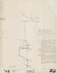
- Telegraph lines and Telegraph stations
- Language:
- eng
- Date Created:
- 1865
- Rights Statement:
- No Copyright - Non-Commercial Use Only
- Resource Type:
- Still Image
- Identifier:
- LSV Number: 10T2MISC, 107159, and Historical Map Society of B.C. Map Number: 1991
- Extent:
- 1 sheet ; 48 x 60 cm
- Geographic Coverage:
- British Columbia--New Westminster, British Columbia--Fraser River, and Pacific Ocean--Semiahmoo Bay
- Coordinates:
- 49.20694, -122.91111, 49.11636, -123.18594, and 49.01636, -122.81796
- Additional Physical Characteristics:
- Scale: about 1 Inch to a Mile
- Physical Repository:
- Land Title and Survey Authority of British Columbia
- Collection:
- Land Title and Survey Authority of British Columbia: Early British Columbia Maps
- Provenance:
- Surveyor General of BC, Legal Surveys Vault
- Provider:
- University of Victoria (B.C.). Library
- Genre:
- relief maps, historical maps, and maps (documents)
- Date Digitized:
- 2011-02-17
- Technical Note:
- Cataloguing metadata: Provided by the LTSA and adapted by the University of Victoria Libraries to their requirements.