Search
Search Results
- Alternative Title:
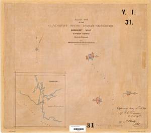
- Plan No. 2 of the Clayoquot Sound Indian Reserves, Manhauset Band, Clayoquot District British Columbia
- Subject:
- Land titles--Maps, Land titles, Land use, Land cover, Indian reservations, and Indigenous peoples
- Creator:
- Surveyor General of British Columbia
- Contributor:
- Devereux, Francis Algernon, 1867-1960
- Language:
- eng
- Date Created:
- 1893 to 1894
- Rights Statement:
- No Copyright - Non-Commercial Use Only
- Resource Type:
- Still Image
- Identifier:
- Plan Barcode: Z0366494, LTSA SGD Microfilm Image Number: 106511, Plan Number: 31TR-IR (Vancouver Island), and LTSA Inventory No.: LTSA6176
- Extent:
- 1 sheet
- Geographic Coverage:
- British Columbia--Alberni-Clayoquot, British Columbia--Flores Island, British Columbia--Openit Peninsula, and Pacific Ocean--Sydney Inlet
- Coordinates:
- 49.35951, -126.2602, 49.51628, -126.30293, 49.33288, -126.16961, 49.38952, -126.2463, and 49.36063, -126.22652
- Additional Physical Characteristics:
- Scale: 1 inch = 40 chains
- Physical Repository:
- Land Title and Survey Authority of British Columbia
- Collection:
- Land Title and Survey Authority of British Columbia: Indian Reserve Maps
- Provider:
- University of Victoria (B.C.). Library
- Genre:
- historical maps, maps (documents), and land surveys
- Technical Note:
- Cataloguing metadata: Provided by the LTSA and adapted by University of Victoria Libraries to their requirements.