Search
Search Constraints
Start Over Filtering by: Geographic Coverage United States ✖ Remove constraint Geographic Coverage: United States Subject Parks ✖ Remove constraint Subject: Parks
1 - 10 of 10
Number of results to display per page
Search Results
-

- Alternative Title
- Philadelphus Green Map, Wakulla Green Map, Red Banks Green Map, Maxton Green Map, Pembroke Green Map, Alma Green Map, and Red Springs Green Map
- Subject
- Recreation areas, Recycling (Waste, etc.), Farmers' markets, Parks, Community centers, Gardens, Cycling, Sewage, Plants, Water treatment plants--Waste disposal, and Environmental education
- Creator
- Robeson County Green Map Project
- Contributor
- Robeson County Green Map Project
- Publisher
- Robeson County Green Map Project
- Language
- eng
- Rights Statement
- In Copyright - Educational Use Permitted
- Resource Type
- Text
- Identifier
- Green Map System Number: US85
- Extent
- 1 map : colour ; 35 x 21 cm
- Geographic Coverage
- North Carolina--Pembroke, United States, North Carolina--Alma, North Carolina--Red Banks, North Carolina--Robeson County, North Carolina--Wakulla, North Carolina--Maxton, North Carolina--Philadelphus, and North Carolina--Red Springs
- Coordinates
- 34.70294, -79.25087, 34.75905, -79.17142, 34.73516, -79.34893, 34.72377, -79.31254, 34.64009, -79.10353, 34.68016, -79.19504, 34.79266, -79.25504, 39.76, -98.5, and 34.81516, -79.18309
- Collection
- International Green Maps
- Provenance
- Digital files provided by Green Map System, New York, NY.
- Provider
- University of Victoria (B.C.). Library
- Genre
- maps (documents)
- Date Digitized
- 2004-05-06
- Technical Note
- 200 dpi TIFF. Received in digital format. Metadata by PD and MT.
-

- Subject
- Parks, Water treatment plants--Waste disposal, Water--Purification, Recycling (Waste, etc.), Natural areas, Habitat (Ecology), Sewage, Local transit, Compost, Natural foods, Environmental management, Museums, and Farmers' markets
- Creator
- Miller, Gayle
- Publisher
- Mid-Michigan Green Map
- Language
- eng
- Date created
- 1995
- Rights Statement
- In Copyright - Educational Use Permitted
- Resource Type
- Text
- Identifier
- Green Map System Number: US31
- Extent
- 1 map : colour ; 62 x 47 cm
- Geographic Coverage
- Michigan--Eaton County, Michigan--Shiawassee County, Michigan--Ingham County, Michigan--Ionia County, United States, Michigan, and Michigan--Clinton County
- Coordinates
- 44.25029, -85.50033, 42.5971, -84.37354, 42.94509, -85.0746, 42.95373, -84.14673, 42.59607, -84.83831, 39.76, -98.5, and 42.94365, -84.60152
- Chronological Coverage
- 1995
- Collection
- International Green Maps
- Provenance
- Digital files provided by Green Map System, New York, NY.
- Provider
- University of Victoria (B.C.). Library
- Genre
- maps (documents)
- Date Digitized
- 2007-06-19
- Technical Note
- Adobe PDF. Received in digital format. Metadata by PD and MT.
-

- Subject
- Community gardens, Parks, and Recycling (Waste, etc.)
- Creator
- Architects, Designers, Planners for Social Responsibility. Northern California Chapter
- Contributor
- Garcia, Carol, Novik, Linda, Lytle, Jacqueline, Van Mechelen, Greg, Smith, Kathleen, and Merola, Linda
- Publisher
- Inkworks Press
- Language
- eng
- Date created
- 1998
- Rights Statement
- In Copyright - Educational Use Permitted
- Resource Type
- Still Image
- Identifier
- Green Map System Number: US19
- Extent
- 1 map : colour ; 27 x 43 cm
- Geographic Coverage
- California--Berkeley and United States
- Coordinates
- 39.76, -98.5 and 37.87159, -122.27275
- Chronological Coverage
- 1998
- Collection
- International Green Maps
- Provenance
- Digital files provided by Green Map System, New York, NY.
- Provider
- University of Victoria (B.C.). Library
- Genre
- maps (documents)
- Date Digitized
- 2007-06-11
- Technical Note
- Adobe PDF. Received in digital format. Metadata by PD and MT.
-
- Subject
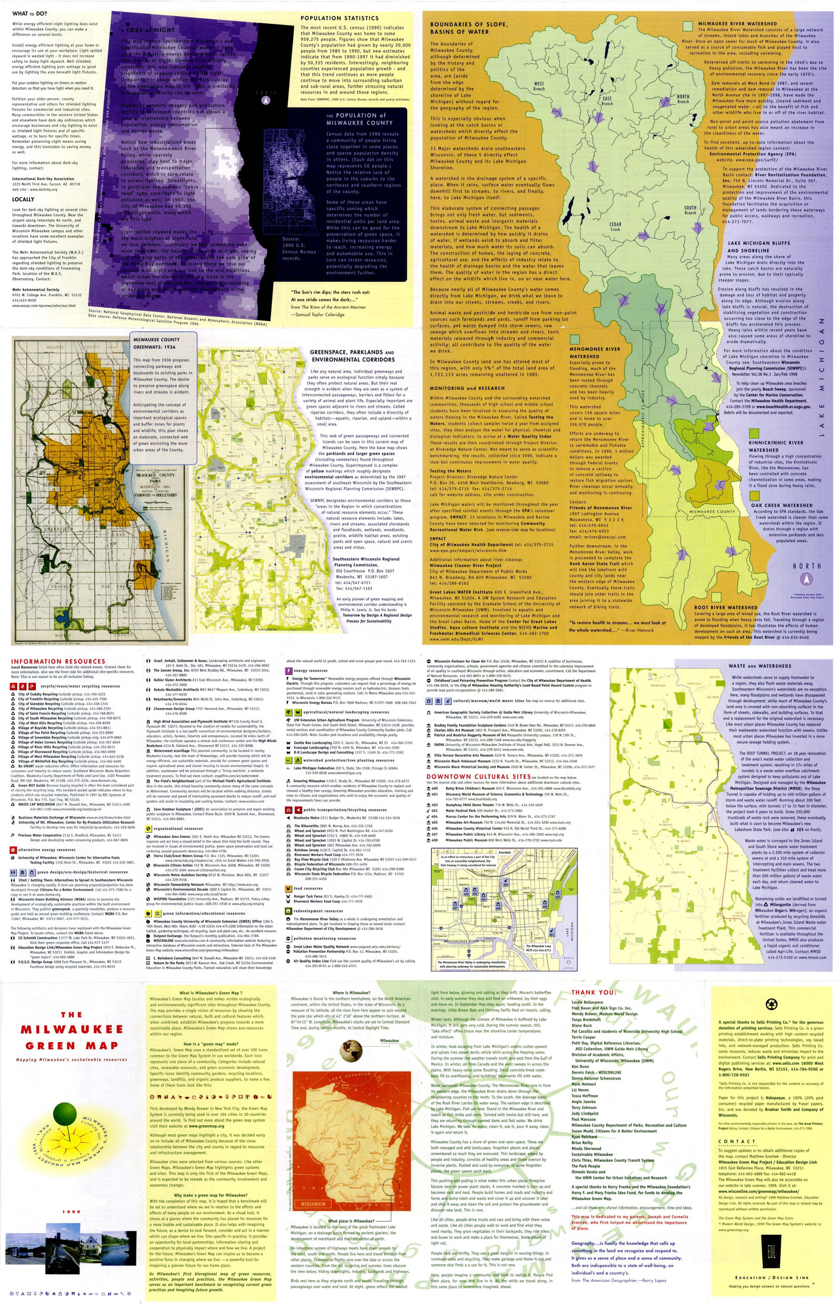
- Renewable energy sources, Watersheds, Culture, Thrift shops, Environmental education, Farmers' markets, Cycling, Natural areas, Wildlife conservation, Community gardens, Population--Statistics, Parks, Fair trade foods, Open spaces, Local transit, Animals, and Recycling (Waste, etc.)
- Creator
- Milwaukee Green Map Project
- Contributor
- Groshek, Matthew
- Publisher
- Sells Printing Co.
- Language
- eng
- Date created
- 1999
- Rights Statement
- In Copyright - Educational Use Permitted
- Resource Type
- Still Image
- Identifier
- Green Map System Number: US52
- Extent
- 1 map : colour ; 86 x 55 cm
- Geographic Coverage
- Wisconsin--Milwaukee and United States
- Coordinates
- 39.76, -98.5 and 43.0389, -87.90647
- Chronological Coverage
- 1999
- Collection
- International Green Maps
- Provenance
- Digital files provided by Green Map System, New York, NY.
- Provider
- University of Victoria (B.C.). Library
- Genre
- maps (documents)
- Date Digitized
- 2007-06-11
- Technical Note
- Adobe PDF. Received in digital format. Metadata by PD and MT.
-
- Alternative Title
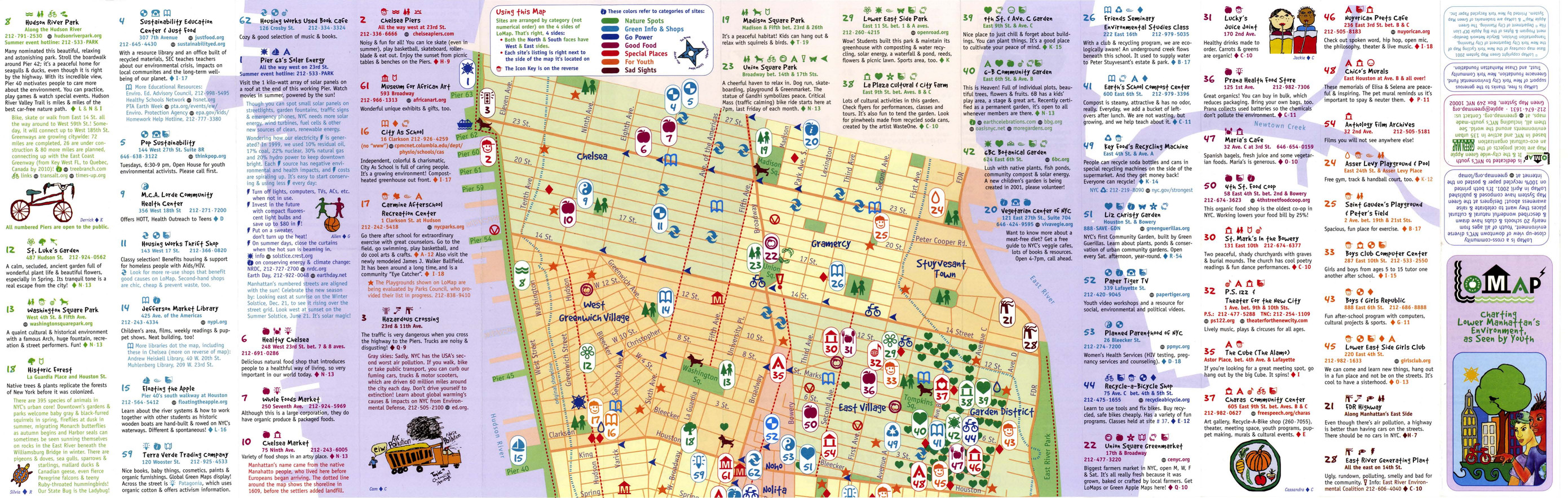
- LoMap: explore downtown's environment as guided by youth
- Subject
- Libraries, Public art, Farmers' markets, Community centers, Museums, Recycling (Waste, etc.), Air--Pollution, Local transit, Recreation centers, Thrift shops, Voluntarism, Culture, Animals, Parks, Recreation areas, Renewable energy sources, Community gardens, and Plants
- Creator
- Green Map System (Firm)
- Contributor
- Kline, Diana Signe, Ferguson, Beth, and Brawer, Wendy E.
- Publisher
- New York Recycled Paper Inc.
- Language
- eng
- Date created
- 2000
- Rights Statement
- In Copyright - Educational Use Permitted
- Resource Type
- Still Image
- Identifier
- Green Map System Number: US3
- Extent
- 1 map : colour ; 94 x 30 cm
- Geographic Coverage
- New York (State)--New York--Manhattan, New York (State), and United States
- Coordinates
- 40.78343, -73.96625, 40.71427, -74.00597, and 39.76, -98.5
- Chronological Coverage
- 2000
- Collection
- International Green Maps
- Provenance
- Digital files provided by Green Map System, New York, NY.
- Provider
- University of Victoria (B.C.). Library
- Genre
- maps (documents)
- Date Digitized
- 2007-06-11
- Technical Note
- Adobe PDF. Received in digital format. Metadata by PD and MT.
-

- Alternative Title
- Sabin neighborhood greenmap: a Portland Greenmap pilot project sponsored by Nature's Northwest
- Subject
- Public art, Cycling, Libraries, Playgrounds, Community centers, Habitat (Ecology), Parks, Natural foods, Community gardens, Thrift shops, Forests and forestry, and Environmental education
- Creator
- Portland Greenmap
- Contributor
- King, Jason and Kausfamann, Cathy
- Publisher
- Portland Greenmap
- Language
- eng
- Date created
- 2001
- Rights Statement
- In Copyright - Educational Use Permitted
- Resource Type
- Still Image
- Identifier
- Green Map System Number: US38
- Extent
- 1 map : colour ; 27 x 43 cm
- Geographic Coverage
- Oregon--Portland and United States
- Coordinates
- 45.52345, -122.67621 and 39.76, -98.5
- Chronological Coverage
- 2001
- Collection
- International Green Maps
- Provenance
- Digital files provided by Green Map System, New York, NY.
- Provider
- University of Victoria (B.C.). Library
- Genre
- maps (documents)
- Date Digitized
- 2007-06-19
- Technical Note
- Adobe PDF. Received in digital format. Metadata by PD and MT.
-

- Subject
- Recycling (Waste, etc.), Community gardens, Cycling, Neighborhoods, Culture, Animals, Trees, Parks, Older people, Farmers' markets, Community centers, Outdoor recreation, and Local transit
- Creator
- Green Map System (Firm)
- Contributor
- Green Map System (Firm)
- Publisher
- Green Map System
- Language
- eng
- Date created
- 2005
- Rights Statement
- In Copyright - Educational Use Permitted
- Resource Type
- Still Image
- Identifier
- Green Map System Number: US102
- Extent
- 1 map : colour
- Geographic Coverage
- United States and New York (State)--New York--Flushing Meadows-Corona Park
- Coordinates
- 39.76, -98.5 and 40.7401, -73.84069
- Chronological Coverage
- 2005
- Collection
- International Green Maps
- Provenance
- Digital files provided by Green Map System, New York, NY.
- Provider
- University of Victoria (B.C.). Library
- Genre
- maps (documents)
- Date Digitized
- 2012-01-07
- Technical Note
- 72 dpi JPG. Received in digital format. Metadata by PD and MT.
-
- Alternative Title
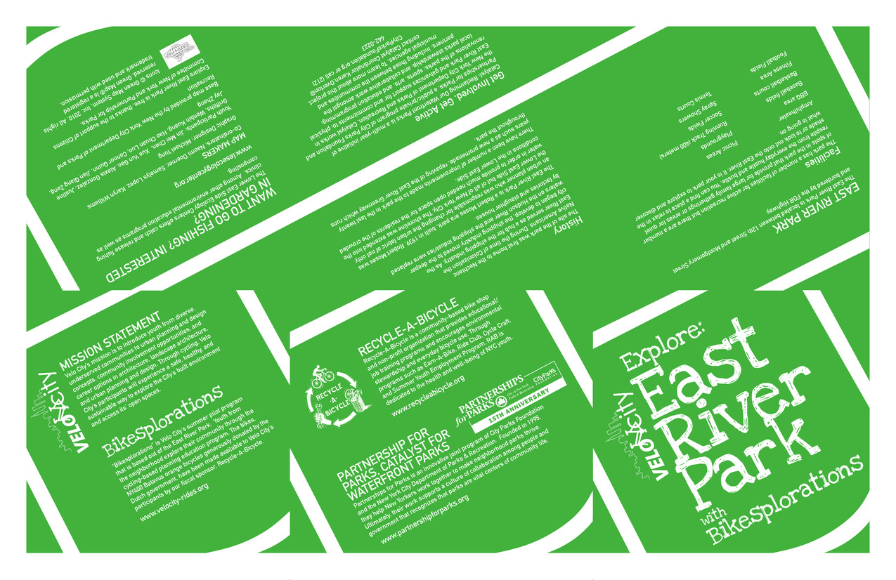
- Velo City Explore East River Park with Bikesplorations
- Subject
- Parks
- Creator
- Velo City
- Contributor
- Griffiths, Justine, Kuang, Wenbin, Zeng, Jian Qiang, Gao, Xue Yun, Williams, Karyn, Doerner, Naomi, Chen, Jin Mei, Luo, Hao Chuan, Zhang, Jay, Quinn, Connor, Gonzalez, Alexis, Lopez, Samelys, and Yong, Michael
- Publisher
- Lower East Side Ecology Centers
- Language
- eng
- Date created
- 2009
- Rights Statement
- In Copyright - Educational Use Permitted
- Resource Type
- Still Image
- Identifier
- Green Map System Number: US72
- Extent
- 1 map : colour ; 27 x 43 cm
- Geographic Coverage
- New York (State), New York (State)--New York--Manhattan, and United States
- Coordinates
- 39.76, -98.5, 40.71427, -74.00597, and 40.78343, -73.96625
- Chronological Coverage
- 2009
- Collection
- International Green Maps
- Provenance
- Digital files provided by Green Map System, New York, NY.
- Provider
- University of Victoria (B.C.). Library
- Genre
- maps (documents)
- Date Digitized
- 2012-01-10
- Technical Note
- Adobe PDF. Received in digital format. Metadata by PD and MT.
- Keyword in Context
- VEL080510_r4.indd Exp lore : Eas t Riv er Par k wit h Bik esp lora tion s MIS SIO n S TAT EM EnT Velo Cit y’s mis sion is t o in trod uce you th f rom div ers e, und ers erv ed c om mu niti es t o u rba n p lan nin g an d d esig n ...
-
- Subject
- Food banks, Renewable energy sources, Farmers' markets, Air--Pollution, Environmental justice, Recycling (Waste, etc.), Parks, Water harvesting, Community gardens, and Voluntarism
- Creator
- Faith Leaders for Environmental Justice and Center for International Earth Science Information Network
- Publisher
- Green Map System
- Language
- eng
- Date created
- 2010
- Rights Statement
- In Copyright - Educational Use Permitted
- Resource Type
- Text
- Identifier
- Green Map System Number: US64
- Extent
- 1 map : colour ; 27 x 43 cm
- Geographic Coverage
- United States and New York (State)--New York--Harlem
- Coordinates
- 40.80788, -73.94542 and 39.76, -98.5
- Chronological Coverage
- 2010
- Collection
- International Green Maps
- Provenance
- Digital files provided by Green Map System, New York, NY.
- Provider
- University of Victoria (B.C.). Library
- Genre
- maps (documents)
- Date Digitized
- 2012-01-09
- Technical Note
- Adobe PDF. Received in digital format. Metadata by PD and MT.
-

- Alternative Title
- Espacio para Respirar
- Subject
- Sewage disposal plants, Mural painting and decoration, Air--Pollution, Cycling, Sewage, Public art, Waterfronts, and Parks
- Creator
- Azzarello, Pasqualina
- Publisher
- Recycle-A-Bicycle
- Language
- spa and eng
- Date created
- 2012
- Rights Statement
- In Copyright - Educational Use Permitted
- Resource Type
- Still Image
- Identifier
- Green Map System Number: US9
- Extent
- 1 map : colour ; 27 x 43 cm
- Geographic Coverage
- New York (State)--New York and United States
- Coordinates
- 40.71427, -74.00597 and 39.76, -98.5
- Chronological Coverage
- 2012
- Collection
- International Green Maps
- Provenance
- Digital files provided by Green Map System, New York, NY.
- Provider
- University of Victoria (B.C.). Library
- Genre
- maps (documents)
- Date Digitized
- 2004-05-06
- Technical Note
- 200 dpi TIFF. Received in digital format. Metadata by PD and MT.