Search
Search Results
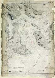
- Subject:
- Nautical charts
- Creator:
- Richards, G. H. (George Henry)
- Contributor:
- J. & C. Walker (Firm)
- Publisher:
- Great Britain, Hydrographic Office
- Language:
- eng
- Date Created:
- 1858 to 1879
- Rights Statement:
- In Copyright - Educational Use Permitted
- Resource Type:
- Still Image
- Identifier:
- Penfold Number: 480
- Extent:
- 1 sheet
- Geographic Coverage:
- Pacific Ocean--Haro Strait and British Columbia--Victoria
- Coordinates:
- 48.54876, -123.21918 and 48.4359, -123.35155
- Chronological Coverage:
- 1858/1879
- Additional Physical Characteristics:
- 1:72,900
- Physical Repository:
- National Archives (Great Britain)
- Collection:
- Early BC Maps Collection
- Provenance:
- National Archives of the UK
- Provider:
- University of Victoria (B.C.). Library
- Genre:
- maps (documents) and historical maps
- Archival Item Identifier:
- National Archives Number: WO78-2311 (18)
- Date Digitized:
- 2010-04-12
- Transcript:
- To accompany my report of this day's date, J.B. Lovell, Colonel C. R. Engineer, Halifax, N.S. 20th December 1879
- Technical Note:
- Watermarks added to images by KM, JF, and CDW. Metadata by CDW, April 30, 2010 and 600 dpi jpg