Search
Search Results
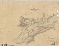
- Subject:
- Cadastral maps and City planning
- Creator:
- McColl, William and Sinnett, Charles
- Language:
- eng
- Date Created:
- September 1860
- Rights Statement:
- No Copyright - Non-Commercial Use Only
- Resource Type:
- Still Image
- Identifier:
- LSV Number: 12T2TS "22", Historical Map Society of B.C. Map Number: 1499, and 106073
- Extent:
- 1 sheet ; 48 x 65 cm
- Geographic Coverage:
- British Columbia--Lytton, British Columbia--Fraser River, and British Columbia--Thompson River
- Coordinates:
- 50.23194, -121.58196, 50.23304, -121.58589, and 49.11636, -123.18594
- Additional Physical Characteristics:
- Scale: Six Inches to a Mile
- Physical Repository:
- Land Title and Survey Authority of British Columbia
- Collection:
- Land Title and Survey Authority of British Columbia: Early British Columbia Maps
- Provenance:
- Surveyor General of BC, Legal Surveys Vault
- Provider:
- University of Victoria (B.C.). Library
- Genre:
- cadastral maps, historical maps, maps (documents), and relief maps
- Date Digitized:
- 2011-09-30
- Technical Note:
- Cataloguing metadata: Provided by the LTSA and adapted by the University of Victoria Libraries to their requirements.