Search
Search Constraints
Start Over Filtering by: Collection International Green Maps ✖ Remove constraint Collection: International Green Maps Subject Community gardens ✖ Remove constraint Subject: Community gardens
« Previous |
1 - 10 of 12
|
Next »
Number of results to display per page
Search Results
-
- Alternative Title
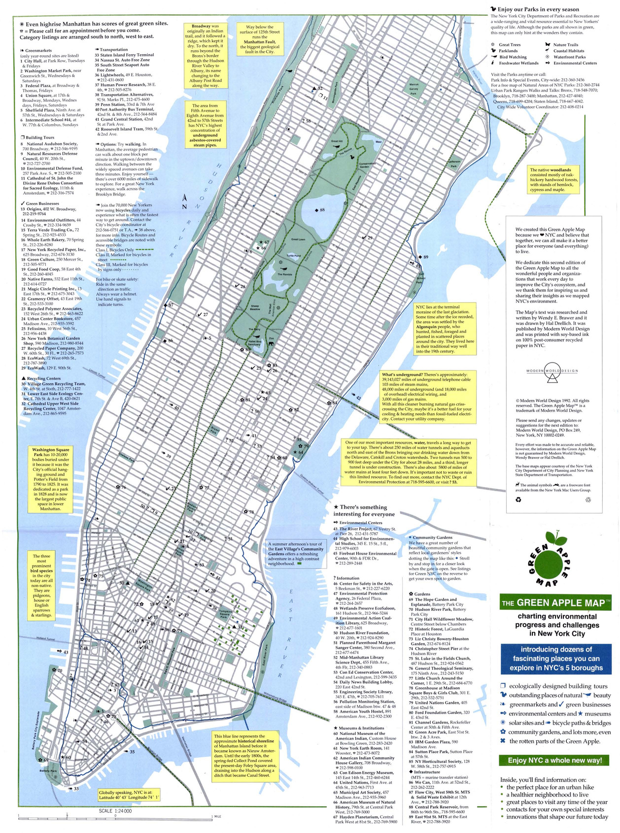
- Green Map NYC
- Subject
- Sustainable buildings, Zoos, Refuse and refuse disposal, Local transit, Recycling (Waste, etc.), Farmers' markets, Sustainable living, Community gardens, and Museums
- Creator
- Drelich, Hal
- Contributor
- Brawer, Wendy E.
- Publisher
- Modern World Design
- Language
- eng
- Date created
- 1994
- Rights Statement
- In Copyright - Educational Use Permitted
- Resource Type
- Still Image
- Identifier
- Green Map System Number: US1
- Extent
- 1 map : colour ; 43 x 27 cm
- Edition
- 2nd edition
- Geographic Coverage
- New York (State)--New York and United States
- Coordinates
- 40.71427, -74.00597 and 39.76, -98.5
- Chronological Coverage
- 1992
- Collection
- International Green Maps
- Provenance
- Digital files provided by Green Map System, New York, NY.
- Provider
- University of Victoria (B.C.). Library
- Genre
- maps (documents)
- Date Digitized
- 2007-06-11
- Technical Note
- Adobe PDF. Received in digital format. Metadata by PD and MT.
-

- Subject
- Community gardens, Parks, and Recycling (Waste, etc.)
- Creator
- Architects, Designers, Planners for Social Responsibility. Northern California Chapter
- Contributor
- Garcia, Carol, Novik, Linda, Lytle, Jacqueline, Van Mechelen, Greg, Smith, Kathleen, and Merola, Linda
- Publisher
- Inkworks Press
- Language
- eng
- Date created
- 1998
- Rights Statement
- In Copyright - Educational Use Permitted
- Resource Type
- Still Image
- Identifier
- Green Map System Number: US19
- Extent
- 1 map : colour ; 27 x 43 cm
- Geographic Coverage
- California--Berkeley and United States
- Coordinates
- 39.76, -98.5 and 37.87159, -122.27275
- Chronological Coverage
- 1998
- Collection
- International Green Maps
- Provenance
- Digital files provided by Green Map System, New York, NY.
- Provider
- University of Victoria (B.C.). Library
- Genre
- maps (documents)
- Date Digitized
- 2007-06-11
- Technical Note
- Adobe PDF. Received in digital format. Metadata by PD and MT.
-
- Subject
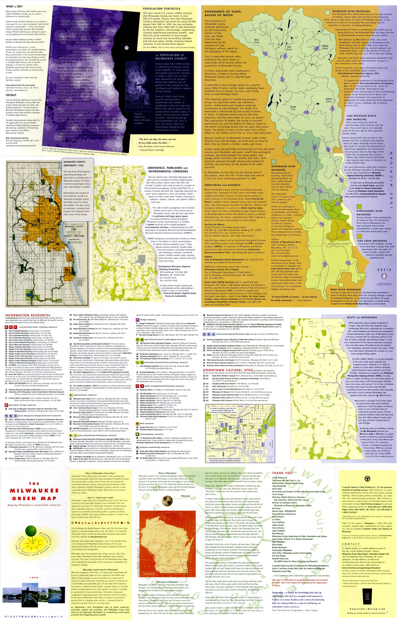
- Renewable energy sources, Watersheds, Culture, Thrift shops, Environmental education, Farmers' markets, Cycling, Natural areas, Wildlife conservation, Community gardens, Population--Statistics, Parks, Fair trade foods, Open spaces, Local transit, Animals, and Recycling (Waste, etc.)
- Creator
- Milwaukee Green Map Project
- Contributor
- Groshek, Matthew
- Publisher
- Sells Printing Co.
- Language
- eng
- Date created
- 1999
- Rights Statement
- In Copyright - Educational Use Permitted
- Resource Type
- Still Image
- Identifier
- Green Map System Number: US52
- Extent
- 1 map : colour ; 86 x 55 cm
- Geographic Coverage
- Wisconsin--Milwaukee and United States
- Coordinates
- 39.76, -98.5 and 43.0389, -87.90647
- Chronological Coverage
- 1999
- Collection
- International Green Maps
- Provenance
- Digital files provided by Green Map System, New York, NY.
- Provider
- University of Victoria (B.C.). Library
- Genre
- maps (documents)
- Date Digitized
- 2007-06-11
- Technical Note
- Adobe PDF. Received in digital format. Metadata by PD and MT.
-
- Alternative Title
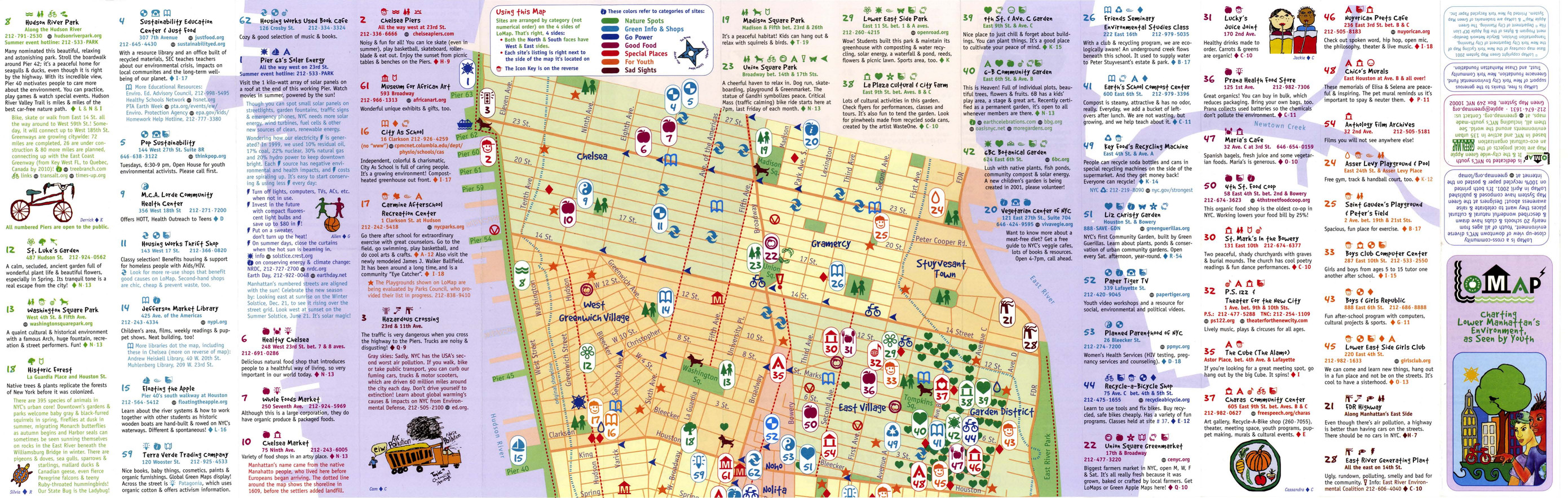
- LoMap: explore downtown's environment as guided by youth
- Subject
- Libraries, Public art, Farmers' markets, Community centers, Museums, Recycling (Waste, etc.), Air--Pollution, Local transit, Recreation centers, Thrift shops, Voluntarism, Culture, Animals, Parks, Recreation areas, Renewable energy sources, Community gardens, and Plants
- Creator
- Green Map System (Firm)
- Contributor
- Kline, Diana Signe, Ferguson, Beth, and Brawer, Wendy E.
- Publisher
- New York Recycled Paper Inc.
- Language
- eng
- Date created
- 2000
- Rights Statement
- In Copyright - Educational Use Permitted
- Resource Type
- Still Image
- Identifier
- Green Map System Number: US3
- Extent
- 1 map : colour ; 94 x 30 cm
- Geographic Coverage
- New York (State)--New York--Manhattan, New York (State), and United States
- Coordinates
- 40.78343, -73.96625, 40.71427, -74.00597, and 39.76, -98.5
- Chronological Coverage
- 2000
- Collection
- International Green Maps
- Provenance
- Digital files provided by Green Map System, New York, NY.
- Provider
- University of Victoria (B.C.). Library
- Genre
- maps (documents)
- Date Digitized
- 2007-06-11
- Technical Note
- Adobe PDF. Received in digital format. Metadata by PD and MT.
-

- Subject
- Trees, Sustainable buildings, Sewage disposal plants, Fair trade foods, Parks, Wetlands, Culture, Wildlife conservation, Museums, Community centers, Local transit, Open spaces, Environmental education, Renewable energy sources, Community gardens, Animals, Recycling (Waste, etc.), Public art, and Farmers' markets
- Creator
- City of Melbourne
- Contributor
- RMIT University. Centre for Design
- Publisher
- City of Melbourne
- Language
- eng
- Date created
- 2001
- Rights Statement
- In Copyright - Educational Use Permitted
- Resource Type
- Still Image
- Identifier
- Green Map System Number: AU2
- Extent
- 1 map : colour ; 68 x 62 cm
- Geographic Coverage
- Australia and Victoria--Melbourne
- Coordinates
- -25, 135 and -37.814, 144.96332
- Chronological Coverage
- 2001
- Collection
- International Green Maps
- Provenance
- Digital files provided by Green Map System, New York, NY.
- Provider
- University of Victoria (B.C.). Library
- Genre
- maps (documents)
- Date Digitized
- 2007-06-19
- Technical Note
- Adobe PDF. Received in digital format. Metadata by PD and MT.
-

- Alternative Title
- Sabin neighborhood greenmap: a Portland Greenmap pilot project sponsored by Nature's Northwest
- Subject
- Public art, Cycling, Libraries, Playgrounds, Community centers, Habitat (Ecology), Parks, Natural foods, Community gardens, Thrift shops, Forests and forestry, and Environmental education
- Creator
- Portland Greenmap
- Contributor
- King, Jason and Kausfamann, Cathy
- Publisher
- Portland Greenmap
- Language
- eng
- Date created
- 2001
- Rights Statement
- In Copyright - Educational Use Permitted
- Resource Type
- Still Image
- Identifier
- Green Map System Number: US38
- Extent
- 1 map : colour ; 27 x 43 cm
- Geographic Coverage
- Oregon--Portland and United States
- Coordinates
- 45.52345, -122.67621 and 39.76, -98.5
- Chronological Coverage
- 2001
- Collection
- International Green Maps
- Provenance
- Digital files provided by Green Map System, New York, NY.
- Provider
- University of Victoria (B.C.). Library
- Genre
- maps (documents)
- Date Digitized
- 2007-06-19
- Technical Note
- Adobe PDF. Received in digital format. Metadata by PD and MT.
-

- Subject
- Community gardens, Public art, Plants, and Archaeology
- Publisher
- Tamagawa Tri-Area Green Map
- Language
- jpn
- Date created
- 2002
- Rights Statement
- In Copyright - Educational Use Permitted
- Resource Type
- Text
- Identifier
- Green Map System Number: JP28
- Extent
- 1 map : colour ; 59 x 42 cm
- Geographic Coverage
- Japan--Tokyo and Japan--Tama River (Yamanashi-ken-Tokyo)
- Coordinates
- 35.6895, 139.69171 and 35.5218, 139.7983
- Chronological Coverage
- 2002
- Collection
- International Green Maps
- Provenance
- Digital files provided by Green Map System, New York, NY.
- Provider
- University of Victoria (B.C.). Library
- Genre
- maps (documents)
- Date Digitized
- 2019-12-11
- Technical Note
- Adobe PDF. Received in digital format. Metadata by PD and MT.
- Keyword in Context
- E-3 ••rn-tt*■ (-IJ'?7) .:A.t,1Jtl,f�i!.ll'7>J:t:a,9�lll1.i -+t?7'7>1E'7>�1ilt:tr-?,t �f$ff ?'t� ,e:-?� 1:a a oti.-?>. E-3 ••111aaie•11�H:t 11t83*1X:Ell1·5·1 tel:03-3701- 1679 iiiII, ,e,:..i;-?>Jt.!1'7>r =:J-�it>lf�tl{l l:'.li• m:!au t:$l,i2,&'.>1!1'f_H,. C-t ll!iR,t•J;...
-

- Alternative Title
- Community Green Map by the Youth After-School Program at Franklin Wright Settlement with the Detroit Green Map Team
- Subject
- Community gardens, Compost--Environmental aspects, Natural areas, and Compost
- Creator
- Detroit Green Map Team
- Contributor
- Schröder, Vibeke, Detroit Green Map Team, Franklin Wright Settlement Community Center, and Stephan, Nicole
- Publisher
- Detroit Green Map Team
- Language
- eng
- Date created
- 2003
- Rights Statement
- In Copyright - Educational Use Permitted
- Resource Type
- Still Image
- Identifier
- Green Map System Number: US88
- Extent
- 1 map : colour ; 33 x 47 cm
- Geographic Coverage
- United States and Michigan--Detroit
- Coordinates
- 42.33143, -83.04575 and 39.76, -98.5
- Chronological Coverage
- 2003
- Collection
- International Green Maps
- Provenance
- Digital files provided by Green Map System, New York, NY.
- Provider
- University of Victoria (B.C.). Library
- Genre
- maps (documents)
- Date Digitized
- 2004-06-23
- Technical Note
- 300 dpi TIFF. Born digital resource. Metadata by PD and MT.
-

- Alternative Title
- Green Map of Pune: a historical city
- Subject
- Parks, Wildlife conservation, Older people, Museums, Animals, Water harvesting, Community gardens, Farmers' markets, Natural monuments, Public art, Compost, and Culture
- Creator
- Nebula Consultants (Firm)
- Publisher
- Anand Upalekar
- Language
- eng
- Date created
- 2003
- Rights Statement
- In Copyright - Educational Use Permitted
- Resource Type
- Still Image
- Identifier
- Green Map System Number: AS15
- Extent
- 1 map : colour ; 54 x 41 cm
- Geographic Coverage
- India--Pune
- Coordinates
- 18.51957, 73.85535
- Chronological Coverage
- 2003
- Collection
- International Green Maps
- Provenance
- Digital files provided by Green Map System, New York, NY.
- Provider
- University of Victoria (B.C.). Library
- Genre
- maps (documents)
- Date Digitized
- 2004-06-22
- Technical Note
- 300 dpi TIFF. Received in digital format. Metadata by PD and MT.
-

- Alternative Title
- Menteng Green Map
- Subject
- Museums, Water--Pollution, Open spaces, Air--Pollution, Sustainable buildings, Culture, Animals, Parks, Livestock, Cycling, Community centers, Gardens, Community gardens, Local transit, Trees, and Water treatment plants--Waste disposal
- Creator
- Green Mappers Jakarta (Firm)
- Publisher
- Green Mappers Jakarta
- Language
- eng and may
- Date created
- 2004
- Rights Statement
- In Copyright - Educational Use Permitted
- Resource Type
- Text
- Identifier
- Green Map System Number: AS20
- Extent
- 1 map : colour ; 58 x 41 cm
- Geographic Coverage
- Indonesia--Jakarta
- Coordinates
- -6.21462, 106.84513
- Chronological Coverage
- 2003
- Collection
- International Green Maps
- Provenance
- Digital files provided by Green Map System, New York, NY.
- Provider
- University of Victoria (B.C.). Library
- Genre
- maps (documents)
- Date Digitized
- 2018-03-26
- Technical Note
- Adobe PDF. Received in digital format. Metadata by PD and MT.
- Keyword in Context
- ! ~ I ; KH. W ID HASYIM ~ ~ i~5 0.....,43,___......_ \ t I lndeks + Peta Hijau Sungai Ciliwung/lndex + Ciliwung River Green Map I . ; I --~-...of--- l __ _ ~----, I I I I I --. --~--~- ------- mailinglist: greenmapindonesia@yahoogroups.com...