Search
Search Constraints
Start Over Filtering by: Collection International Green Maps ✖ Remove constraint Collection: International Green Maps Subject Outdoor recreation ✖ Remove constraint Subject: Outdoor recreation
1 - 9 of 9
Number of results to display per page
Search Results
-

- Subject
- Wetlands, Parks, Recreation areas, Remote-sensing images, Natural areas, and Outdoor recreation
- Creator
- Sustainable Calgary
- Contributor
- Canada Millennium Partnership Program
- Publisher
- City of Calgary
- Language
- eng
- Date created
- 2000
- Rights Statement
- In Copyright - Educational Use Permitted
- Resource Type
- Still Image
- Identifier
- Green Map System Number: CA16
- Extent
- 1 map : colour ; 83 x 59 cm
- Geographic Coverage
- Alberta--Calgary
- Coordinates
- 51.05011, -114.08529
- Chronological Coverage
- 2000/2001
- Collection
- International Green Maps
- Provenance
- Digital files provided by Green Map System, New York, NY.
- Provider
- University of Victoria (B.C.). Library
- Genre
- maps (documents) and satellite imagery
- Date Digitized
- 2007-05-19
- Technical Note
- Adobe PDF. Received in digital format. Metadata by PD and MT.
-

- Subject
- Plants, Parks, Outdoor recreation, Trees, Community centers, Recycling (Waste, etc.), Museums, and Recreation areas
- Creator
- Nishinomiya-Kofu Senior High School
- Language
- jpn
- Date created
- 2002
- Rights Statement
- In Copyright - Educational Use Permitted
- Resource Type
- Still Image
- Identifier
- Green Map System Number: JP24
- Extent
- 1 map : colour ; 41 x 29 cm
- Geographic Coverage
- Japan--Nishinomiya-shi
- Coordinates
- 34.78194, 135.30247
- Chronological Coverage
- 2002
- Collection
- International Green Maps
- Provenance
- Digital files provided by Green Map System, New York, NY.
- Provider
- University of Victoria (B.C.). Library
- Genre
- maps (documents)
- Date Digitized
- 2007-06-07
- Technical Note
- Adobe PDF. Received in digital format. Metadata by PD and MT.
-

- Subject
- Outdoor recreation, Local transit, Recreation areas, and Biodiversity
- Creator
- Toyota City Green Map, Aichi
- Contributor
- Toyota Seinen Kaigisho (Junior Chamber International Toyota)
- Publisher
- Past Mapmakers
- Language
- jpn
- Date created
- 2003
- Rights Statement
- In Copyright - Educational Use Permitted
- Resource Type
- Text
- Identifier
- Green Map System Number: JP30
- Extent
- 1 map : colour ; 41 x 57 cm
- Geographic Coverage
- Japan--Toyota-shi
- Coordinates
- 35.087, 137.15
- Chronological Coverage
- 2003
- Collection
- International Green Maps
- Provenance
- Digital files provided by Green Map System, New York, NY.
- Provider
- University of Victoria (B.C.). Library
- Genre
- maps (documents)
- Date Digitized
- 2004-06-23
- Technical Note
- 300 dpi TIFF. Born digital resource. Metadata by PD and MT.
-

- Alternative Title
- Kenoh Green Map, Tsubame-Sanjo, Nigata Pref. and Niigata prefecture Kenoh Green Map
- Subject
- Neighborhoods, Museums, Outdoor recreation, Recreation areas, Plants, Trees, Wildlife conservation, and Parks
- Creator
- Yokoki, Hiroyuki
- Publisher
- Tsubame-Sanjo Junior Chamber of Commerce
- Language
- jpn
- Date created
- 2003
- Rights Statement
- In Copyright - Educational Use Permitted
- Resource Type
- Text
- Identifier
- Green Map System Number: JP32
- Extent
- 1 map : colour ; 58 x 41 cm
- Geographic Coverage
- Japan--Tagami-machi, Japan--Teradomari-machi, Japan--Sanjō-shi, Japan--Niigata-ken, and Japan--Tsubame-shi
- Coordinates
- 37.61667, 138.95, 37.69828, 139.06947, 37.52343, 138.91748, 37.6645, 138.92518, and 37.58333, 138.73333
- Chronological Coverage
- 2003
- Collection
- International Green Maps
- Provenance
- Digital files provided by Green Map System, New York, NY.
- Provider
- University of Victoria (B.C.). Library
- Genre
- maps (documents)
- Date Digitized
- 2004-06-23
- Technical Note
- 300 dpi TIFF. Born digital resource. Metadata by PD and MT.
-

- Alternative Title
- Welcome to a green Toronto, The Living City: Experience nature in the Toronto Region, and The City Alive: Discover the true nature of Downtown Toronto
- Subject
- Outdoor recreation--Environmental aspects, Green marketing, Outdoor recreation, Environmental conditions, and Tourist maps
- Creator
- CO2 Creative (Firm)
- Contributor
- Ontario Trillium Foundation, Toronto (Ont.). Urban Development Services, Tourism Toronto, and Toronto and Region Conservation for the Living City
- Publisher
- Green Tourism Association
- Language
- eng
- Date created
- 2003
- Rights Statement
- In Copyright - Educational Use Permitted
- Resource Type
- Text
- Identifier
- Call Number: G3464 T7E635 2003 C6 and Green Map System Number: CA3
- Extent
- 1 map : colour ; 91 x 66 cm
- Edition
- 2nd edition
- Geographic Coverage
- Canada, Ontario--Toronto Region, and Ontario--Toronto
- Coordinates
- 43.70011, -79.4163, 60.10867, -113.64258, and 43.75919, -79.26636
- Chronological Coverage
- 2003
- Additional Physical Characteristics
- Scale: ca. 1:50,000
- Collection
- International Green Maps
- Provenance
- Digital files provided by Green Map System, New York, NY.
- Provider
- University of Victoria (B.C.). Library
- Genre
- maps (documents)
- Date Digitized
- 2004-06-23
- Technical Note
- 300 dpi TIFF. Born digital resource. Metadata by PD and MT.
-

- Subject
- Recycling (Waste, etc.), Community gardens, Cycling, Neighborhoods, Culture, Animals, Trees, Parks, Older people, Farmers' markets, Community centers, Outdoor recreation, and Local transit
- Creator
- Green Map System (Firm)
- Contributor
- Green Map System (Firm)
- Publisher
- Green Map System
- Language
- eng
- Date created
- 2005
- Rights Statement
- In Copyright - Educational Use Permitted
- Resource Type
- Still Image
- Identifier
- Green Map System Number: US102
- Extent
- 1 map : colour
- Geographic Coverage
- United States and New York (State)--New York--Flushing Meadows-Corona Park
- Coordinates
- 39.76, -98.5 and 40.7401, -73.84069
- Chronological Coverage
- 2005
- Collection
- International Green Maps
- Provenance
- Digital files provided by Green Map System, New York, NY.
- Provider
- University of Victoria (B.C.). Library
- Genre
- maps (documents)
- Date Digitized
- 2012-01-07
- Technical Note
- 72 dpi JPG. Received in digital format. Metadata by PD and MT.
-
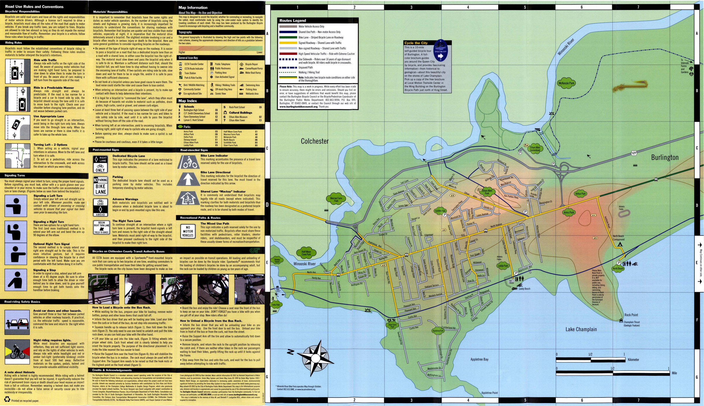
- Subject
- Bicycle commuting, Local transit, Bicycle commuting--Safety measures, Cycling, Outdoor recreation, and Recreation areas
- Creator
- Burlington Bicycle Council
- Contributor
- Lustgarten, David
- Publisher
- Burlington Public Works
- Language
- eng
- Date created
- 2007
- Rights Statement
- In Copyright - Educational Use Permitted
- Resource Type
- Still Image
- Identifier
- Green Map System Number: US87
- Extent
- 1 map : colour ; 80 x 47 cm
- Geographic Coverage
- United States and Vermont--Burlington
- Coordinates
- 44.47588, -73.21207 and 39.76, -98.5
- Chronological Coverage
- 2000/2007
- Collection
- International Green Maps
- Provenance
- Digital files provided by Green Map System, New York, NY.
- Provider
- University of Victoria (B.C.). Library
- Genre
- maps (documents)
- Date Digitized
- 2007-06-19
- Technical Note
- Adobe PDF. Received in digital format. Metadata by PD and MT.
-
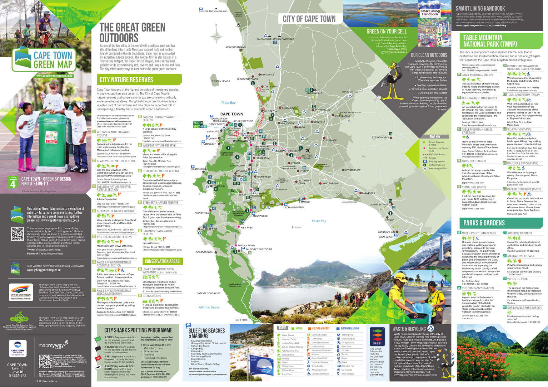
- Alternative Title
- The great green outdoors
- Subject
- Wetland conservation, Outdoor recreation, Watersheds, Natural areas, and Parks
- Creator
- City of Cape Town (South Africa)
- Publisher
- A&C Maps
- Language
- eng
- Date created
- 2013
- Rights Statement
- In Copyright - Educational Use Permitted
- Resource Type
- Text
- Identifier
- Green Map System Number: AF1
- Extent
- 1 map : colour
- Edition
- 4th edition
- Geographic Coverage
- South Africa--Cape Town
- Coordinates
- -33.92584, 18.42322
- Chronological Coverage
- 2013
- Collection
- International Green Maps
- Provenance
- Digital files provided by Green Map System, New York, NY.
- Provider
- University of Victoria (B.C.). Library
- Genre
- maps (documents)
- Date Digitized
- 2013-01-11
- Technical Note
- Adobe PDF. Received in digital format. Metadata by PD and MT.
- Keyword in Context
- This printed Green Map presents a selection of options – for a more complete listing, further information and current news and updates please visit www.capetowngreenmap.co.za Printed on SAPPI Triple Green paper, an environmentally- friendly paper stock made from chlor...
-
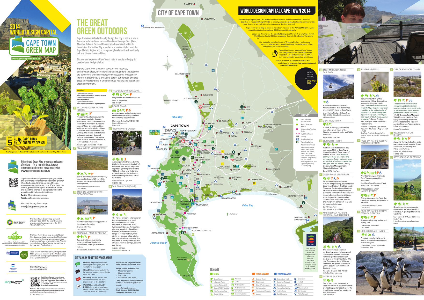
- Alternative Title
- The great green outdoors
- Subject
- Recreation areas, Outdoor recreation, Beaches, Parks, and Nature conservation
- Creator
- City of Cape Town (South Africa)
- Publisher
- A&C Maps
- Language
- eng
- Date created
- 2014
- Rights Statement
- In Copyright - Educational Use Permitted
- Resource Type
- Still Image
- Identifier
- Green Map System Number: AF1
- Extent
- 1 map : colour
- Edition
- 5th edition
- Geographic Coverage
- South Africa--Cape Town
- Coordinates
- -33.92584, 18.42322
- Chronological Coverage
- 2014
- Collection
- International Green Maps
- Provenance
- Digital files provided by Green Map System, New York, NY.
- Provider
- University of Victoria (B.C.). Library
- Genre
- maps (documents)
- Date Digitized
- 2018-03-28
- Technical Note
- Adobe PDF. Received in digital format. Metadata by PD and MT.
- Keyword in Context
- TOKAI CAPE TOWN INTERNATIONAL AIRPORT KOMMETJIE ATLANTIS MAMRE ZEEKOEIVLEI ZANDVLEI RONDEVLEI Seal Island CHAPMAN’S PEAK FALSE BAY NATURE RESERVE Table Bay CAPE TOWN TABLE MOUNTAIN NATIONAL PARK (SILVERMINE) TABLE MOUNTAIN NATIONAL PARK TABLE MOUNTAIN NA...