Search
Search Constraints
Start Over Filtering by: Collection International Green Maps ✖ Remove constraint Collection: International Green Maps Subject Plants ✖ Remove constraint Subject: Plants
1 - 7 of 7
Number of results to display per page
Search Results
-

- Alternative Title
- Philadelphus Green Map, Wakulla Green Map, Red Banks Green Map, Maxton Green Map, Pembroke Green Map, Alma Green Map, and Red Springs Green Map
- Subject
- Recreation areas, Recycling (Waste, etc.), Farmers' markets, Parks, Community centers, Gardens, Cycling, Sewage, Plants, Water treatment plants--Waste disposal, and Environmental education
- Creator
- Robeson County Green Map Project
- Contributor
- Robeson County Green Map Project
- Publisher
- Robeson County Green Map Project
- Language
- eng
- Rights Statement
- In Copyright - Educational Use Permitted
- Resource Type
- Text
- Identifier
- Green Map System Number: US85
- Extent
- 1 map : colour ; 35 x 21 cm
- Geographic Coverage
- North Carolina--Pembroke, United States, North Carolina--Alma, North Carolina--Red Banks, North Carolina--Robeson County, North Carolina--Wakulla, North Carolina--Maxton, North Carolina--Philadelphus, and North Carolina--Red Springs
- Coordinates
- 34.70294, -79.25087, 34.75905, -79.17142, 34.73516, -79.34893, 34.72377, -79.31254, 34.64009, -79.10353, 34.68016, -79.19504, 34.79266, -79.25504, 39.76, -98.5, and 34.81516, -79.18309
- Collection
- International Green Maps
- Provenance
- Digital files provided by Green Map System, New York, NY.
- Provider
- University of Victoria (B.C.). Library
- Genre
- maps (documents)
- Date Digitized
- 2004-05-06
- Technical Note
- 200 dpi TIFF. Received in digital format. Metadata by PD and MT.
-
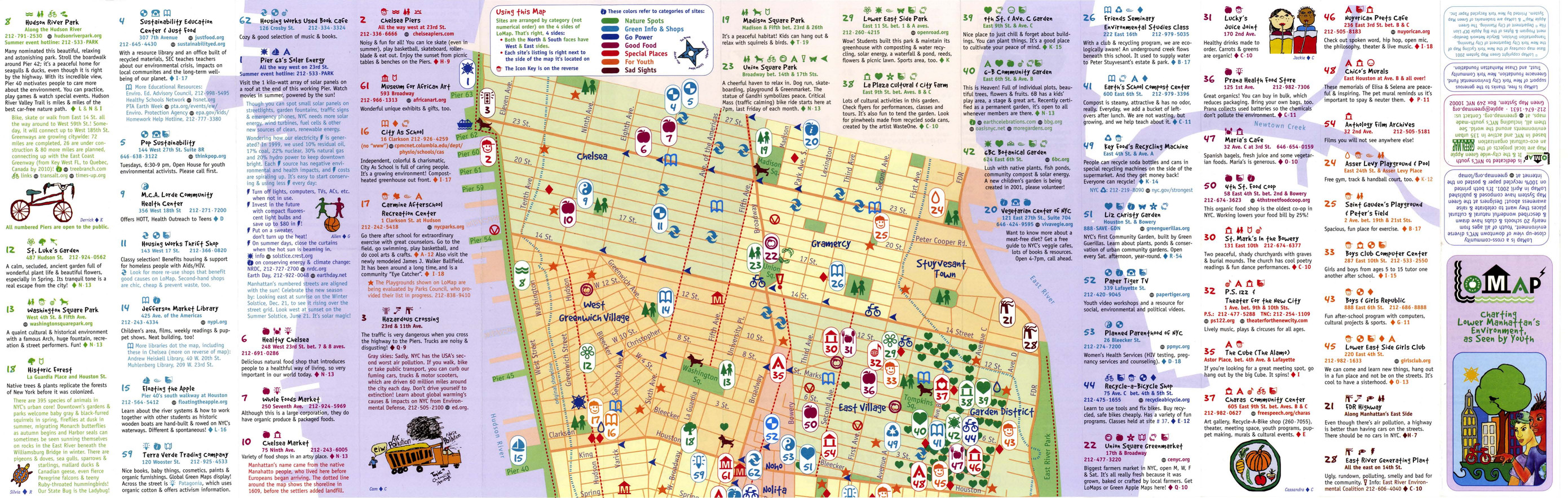
- Alternative Title
- LoMap: explore downtown's environment as guided by youth
- Subject
- Libraries, Public art, Farmers' markets, Community centers, Museums, Recycling (Waste, etc.), Air--Pollution, Local transit, Recreation centers, Thrift shops, Voluntarism, Culture, Animals, Parks, Recreation areas, Renewable energy sources, Community gardens, and Plants
- Creator
- Green Map System (Firm)
- Contributor
- Kline, Diana Signe, Ferguson, Beth, and Brawer, Wendy E.
- Publisher
- New York Recycled Paper Inc.
- Language
- eng
- Date created
- 2000
- Rights Statement
- In Copyright - Educational Use Permitted
- Resource Type
- Still Image
- Identifier
- Green Map System Number: US3
- Extent
- 1 map : colour ; 94 x 30 cm
- Geographic Coverage
- New York (State)--New York--Manhattan, New York (State), and United States
- Coordinates
- 40.78343, -73.96625, 40.71427, -74.00597, and 39.76, -98.5
- Chronological Coverage
- 2000
- Collection
- International Green Maps
- Provenance
- Digital files provided by Green Map System, New York, NY.
- Provider
- University of Victoria (B.C.). Library
- Genre
- maps (documents)
- Date Digitized
- 2007-06-11
- Technical Note
- Adobe PDF. Received in digital format. Metadata by PD and MT.
-

- Alternative Title
- Victoria Falls municipal green map
- Subject
- Natural areas, Parks, Farmers' markets, Sustainable buildings, Deforestation, Waterfalls, Local transit, Forests and forestry, Soil erosion, Habitat (Ecology), Animals, Renewable energy sources, Plants, and Cycling
- Creator
- Victoria Falls Environmental Capacity and Master Plan Project
- Contributor
- Victoria Falls Environmental Capacity and Master Plan Project
- Publisher
- Victoria Falls Environmental Capacity and Master Plan Project
- Language
- eng
- Date created
- 2001
- Rights Statement
- In Copyright - Educational Use Permitted
- Resource Type
- Still Image
- Identifier
- Green Map System Number: AF5
- Extent
- 1 map : colour ; 42 x 27 cm
- Geographic Coverage
- Africa--Victoria Falls and Zimbabwe--Victoria Falls
- Coordinates
- -17.93285, 25.83066
- Chronological Coverage
- 2000
- Collection
- International Green Maps
- Provenance
- Digital files provided by Green Map System, New York, NY.
- Provider
- University of Victoria (B.C.). Library
- Genre
- maps (documents)
- Date Digitized
- 2007-06-19
- Technical Note
- Adobe PDF. Received in digital format. Metadata by PD and MT.
-

- Subject
- Plants, Parks, Outdoor recreation, Trees, Community centers, Recycling (Waste, etc.), Museums, and Recreation areas
- Creator
- Nishinomiya-Kofu Senior High School
- Language
- jpn
- Date created
- 2002
- Rights Statement
- In Copyright - Educational Use Permitted
- Resource Type
- Still Image
- Identifier
- Green Map System Number: JP24
- Extent
- 1 map : colour ; 41 x 29 cm
- Geographic Coverage
- Japan--Nishinomiya-shi
- Coordinates
- 34.78194, 135.30247
- Chronological Coverage
- 2002
- Collection
- International Green Maps
- Provenance
- Digital files provided by Green Map System, New York, NY.
- Provider
- University of Victoria (B.C.). Library
- Genre
- maps (documents)
- Date Digitized
- 2007-06-07
- Technical Note
- Adobe PDF. Received in digital format. Metadata by PD and MT.
-

- Subject
- Community gardens, Public art, Plants, and Archaeology
- Publisher
- Tamagawa Tri-Area Green Map
- Language
- jpn
- Date created
- 2002
- Rights Statement
- In Copyright - Educational Use Permitted
- Resource Type
- Text
- Identifier
- Green Map System Number: JP28
- Extent
- 1 map : colour ; 59 x 42 cm
- Geographic Coverage
- Japan--Tokyo and Japan--Tama River (Yamanashi-ken-Tokyo)
- Coordinates
- 35.6895, 139.69171 and 35.5218, 139.7983
- Chronological Coverage
- 2002
- Collection
- International Green Maps
- Provenance
- Digital files provided by Green Map System, New York, NY.
- Provider
- University of Victoria (B.C.). Library
- Genre
- maps (documents)
- Date Digitized
- 2019-12-11
- Technical Note
- Adobe PDF. Received in digital format. Metadata by PD and MT.
- Keyword in Context
- E-3 ••rn-tt*■ (-IJ'?7) .:A.t,1Jtl,f�i!.ll'7>J:t:a,9�lll1.i -+t?7'7>1E'7>�1ilt:tr-?,t �f$ff ?'t� ,e:-?� 1:a a oti.-?>. E-3 ••111aaie•11�H:t 11t83*1X:Ell1·5·1 tel:03-3701- 1679 iiiII, ,e,:..i;-?>Jt.!1'7>r =:J-�it>lf�tl{l l:'.li• m:!au t:$l,i2,&'.>1!1'f_H,. C-t ll!iR,t•J;...
-

- Alternative Title
- Green World of Prince Alexander, The
- Subject
- Trees, Wildlife conservation, Recreation areas, Nature conservation, Plants, and Parks
- Creator
- Roeloffzen, Anton and van Essen, Jessica
- Contributor
- Lievaart Vormgeving & Communicatie (Firm)
- Publisher
- Centrum voor Natuur en Milieueducatie 'De Blijde Wei'
- Language
- nld
- Date created
- 2003
- Rights Statement
- In Copyright - Educational Use Permitted
- Resource Type
- Still Image
- Identifier
- Green Map System Number: EU7
- Extent
- 1 map : colour ; 49 x 69 cm
- Geographic Coverage
- Netherlands--Rotterdam
- Coordinates
- 51.9225, 4.47917
- Chronological Coverage
- 2003
- Collection
- International Green Maps
- Provenance
- Digital files provided by Green Map System, New York, NY.
- Provider
- University of Victoria (B.C.). Library
- Genre
- maps (documents)
- Date Digitized
- 2018-03-26
- Technical Note
- 200 dpi TIFF. Received in digital format. Metadata by PD and MT.
- Keyword in Context
- I o.p f ~- • Parken, bijzondere bomen en tuinen • Fiets- en wandelroutes Gezien in Prins Alexander Ekster Lepelaar Krooneend Groene specht Putter Torenvalk Groot koolwitje Ringslang ------- \._ \ \ " -~· \ ---------- I I I ------/ --- \ ...
-

- Alternative Title
- Kenoh Green Map, Tsubame-Sanjo, Nigata Pref. and Niigata prefecture Kenoh Green Map
- Subject
- Neighborhoods, Museums, Outdoor recreation, Recreation areas, Plants, Trees, Wildlife conservation, and Parks
- Creator
- Yokoki, Hiroyuki
- Publisher
- Tsubame-Sanjo Junior Chamber of Commerce
- Language
- jpn
- Date created
- 2003
- Rights Statement
- In Copyright - Educational Use Permitted
- Resource Type
- Text
- Identifier
- Green Map System Number: JP32
- Extent
- 1 map : colour ; 58 x 41 cm
- Geographic Coverage
- Japan--Tagami-machi, Japan--Teradomari-machi, Japan--Sanjō-shi, Japan--Niigata-ken, and Japan--Tsubame-shi
- Coordinates
- 37.61667, 138.95, 37.69828, 139.06947, 37.52343, 138.91748, 37.6645, 138.92518, and 37.58333, 138.73333
- Chronological Coverage
- 2003
- Collection
- International Green Maps
- Provenance
- Digital files provided by Green Map System, New York, NY.
- Provider
- University of Victoria (B.C.). Library
- Genre
- maps (documents)
- Date Digitized
- 2004-06-23
- Technical Note
- 300 dpi TIFF. Born digital resource. Metadata by PD and MT.