Search
Search Constraints
Start Over Filtering by: Collection International Green Maps ✖ Remove constraint Collection: International Green Maps Subject Sustainable living ✖ Remove constraint Subject: Sustainable living
1 - 9 of 9
Number of results to display per page
Search Results
-
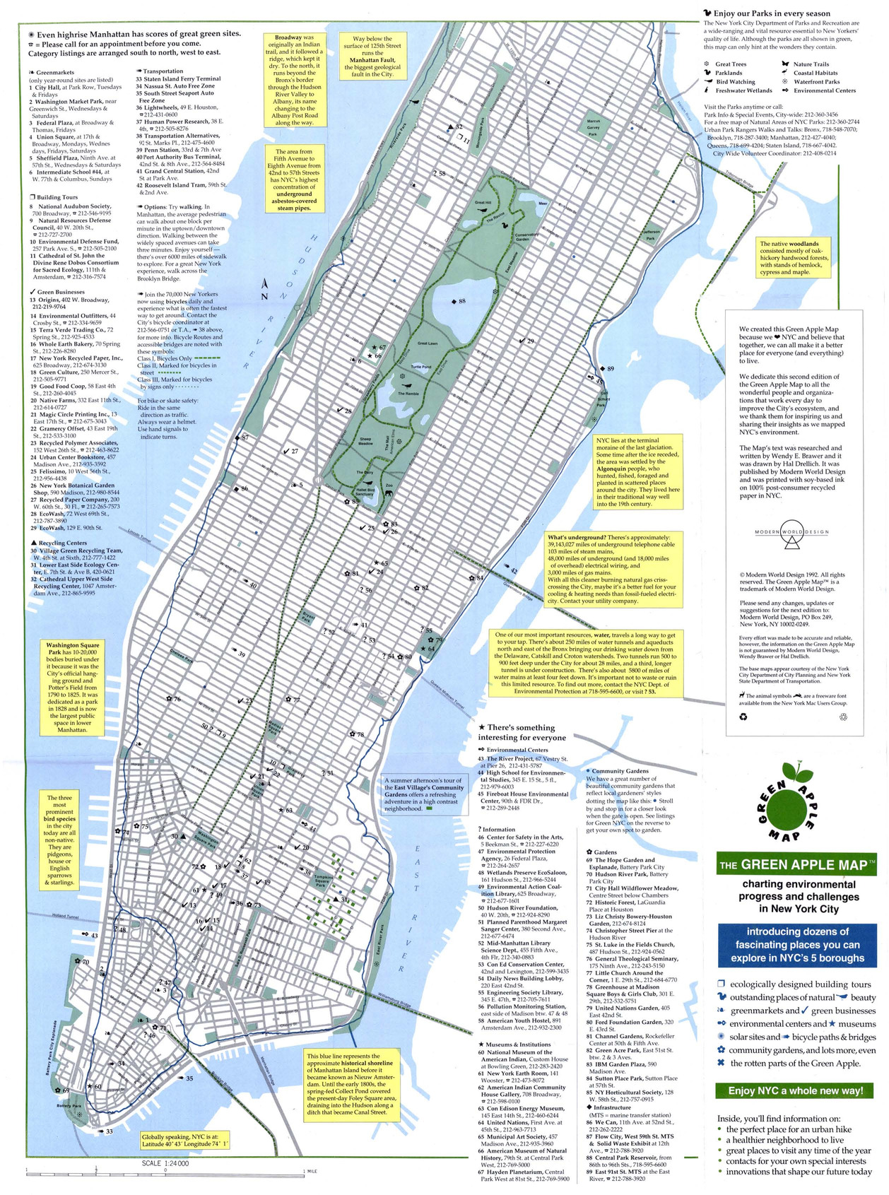
- Alternative Title
- Green Map NYC
- Subject
- Sustainable buildings, Zoos, Refuse and refuse disposal, Local transit, Recycling (Waste, etc.), Farmers' markets, Sustainable living, Community gardens, and Museums
- Creator
- Drelich, Hal
- Contributor
- Brawer, Wendy E.
- Publisher
- Modern World Design
- Language
- eng
- Date created
- 1994
- Rights Statement
- In Copyright - Educational Use Permitted
- Resource Type
- Still Image
- Identifier
- Green Map System Number: US1
- Extent
- 1 map : colour ; 43 x 27 cm
- Edition
- 2nd edition
- Geographic Coverage
- New York (State)--New York and United States
- Coordinates
- 40.71427, -74.00597 and 39.76, -98.5
- Chronological Coverage
- 1992
- Collection
- International Green Maps
- Provenance
- Digital files provided by Green Map System, New York, NY.
- Provider
- University of Victoria (B.C.). Library
- Genre
- maps (documents)
- Date Digitized
- 2007-06-11
- Technical Note
- Adobe PDF. Received in digital format. Metadata by PD and MT.
-

- Alternative Title
- Discover Malmö the green way, Upptäck Malmös gröna sidor, and Malmo Green Map
- Subject
- Sustainable living, Recycling (Waste, etc.)--Citizen participation, Organic farming, Sustainable urban development, Recycling (Waste, etc.), and Local transit
- Creator
- Richter, Bengt-Arne and Fossum, Tor
- Contributor
- Dolocek, John, Gothrick, Hans-Lennart, and Kunskap Malmo
- Publisher
- Malmö Green Map
- Language
- eng and swe
- Date created
- 1999
- Rights Statement
- In Copyright - Educational Use Permitted
- Resource Type
- Still Image
- Identifier
- Green Map System Number: EU17
- Extent
- 1 map : colour ; 59 x 41 cm
- Edition
- 2nd edition
- Geographic Coverage
- Sweden--Malmö
- Coordinates
- 57.81667, 16.7
- Chronological Coverage
- 1999
- Collection
- International Green Maps
- Provenance
- Digital files provided by Green Map System, New York, NY.
- Provider
- University of Victoria (B.C.). Library
- Genre
- maps (documents)
- Date Digitized
- 2007-06-11
- Technical Note
- Adobe PDF. Received in digital format. Metadata by PD and MT.
-

- Alternative Title
- Goteborg and Region Vastra Gotaland Green Map
- Subject
- Wetlands, Local transit, Renewable energy sources, Sustainable living, Community development, Biodiversity, Natural areas, Sustainable urban development, and Sustainable buildings
- Creator
- Göteborg (Sweden). Stadsbyggnadskontoret
- Contributor
- Vastra Gotalandsregionen Miljonamnden
- Publisher
- Ekocentrum
- Language
- eng
- Date created
- 2000
- Rights Statement
- In Copyright - Educational Use Permitted
- Resource Type
- Text
- Identifier
- Green Map System Number: EU12
- Extent
- 1 map : colour ; 41 x 29 cm
- Geographic Coverage
- Sweden--Göteborg
- Coordinates
- 57.70716, 11.96679
- Chronological Coverage
- 2000
- Collection
- International Green Maps
- Provenance
- Digital files provided by Green Map System, New York, NY.
- Provider
- University of Victoria (B.C.). Library
- Genre
- maps (documents)
- Date Digitized
- 2004-05-06
- Technical Note
- 200 dpi TIFF. Born digital resource. Metadata by PD and MT.
-
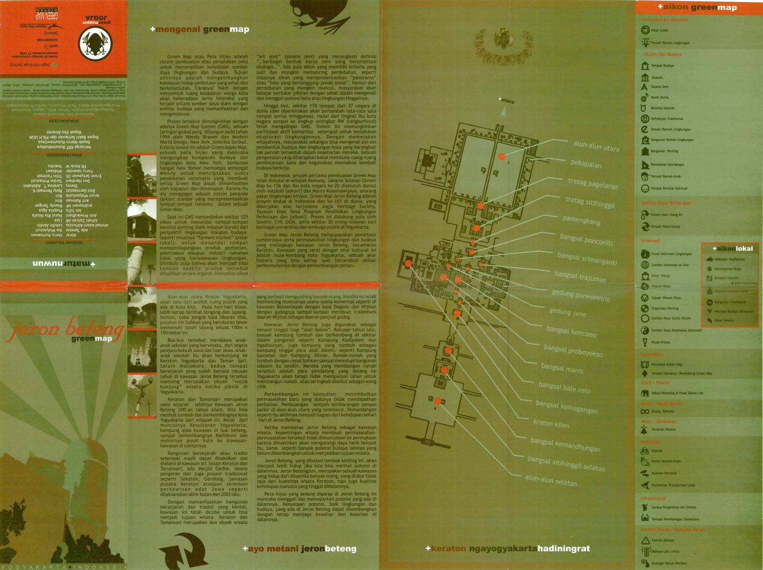
- Alternative Title
- Jeron Beteng Yogyakarta green map
- Subject
- Sustainable living, Neighborhoods, and Natural areas
- Creator
- Green Mapper Jogja
- Contributor
- Universitas Gadjah Mada and Center for Heritage Conservation Department of Architecture, Faculty of Engineering
- Publisher
- Press, Culture & Education Royal Netherlands Embassy
- Language
- ind
- Date created
- 2002
- Rights Statement
- In Copyright - Educational Use Permitted
- Resource Type
- Text
- Identifier
- Green Map System Number: AS21
- Extent
- 1 map : colour ; 62 x 44 cm
- Geographic Coverage
- Indonesia--Yogyakarta
- Coordinates
- -7.80139, 110.36472
- Chronological Coverage
- 2002
- Collection
- International Green Maps
- Provenance
- Digital files provided by Green Map System, New York, NY.
- Provider
- University of Victoria (B.C.). Library
- Genre
- maps (documents)
- Date Digitized
- 2007-06-19
- Technical Note
- Adobe PDF. Received in digital format. Metadata by PD and MT.
-

- Alternative Title
- Peta Hijau Kemang
- Subject
- Natural areas, Neighborhoods, and Sustainable living
- Creator
- Green Map Indonesia
- Publisher
- Green Map Indonesia
- Language
- ind
- Date created
- 2002
- Rights Statement
- In Copyright - Educational Use Permitted
- Resource Type
- Text
- Identifier
- Green Map System Number: AS33
- Extent
- 1 map : colour
- Geographic Coverage
- Indonesia--Jakarta
- Coordinates
- -6.21462, 106.84513
- Chronological Coverage
- 2002
- Collection
- International Green Maps
- Provenance
- Digital files provided by Green Map System, New York, NY.
- Provider
- University of Victoria (B.C.). Library
- Genre
- maps (documents)
- Date Digitized
- 2007-06-19
- Technical Note
- Adobe PDF. Received in digital format. Metadata by PD and MT.
-

- Alternative Title
- Mapa Verde Barrio Chino cuidad de Nueva York
- Subject
- Neighborhoods, Renewable energy sources, Sustainable urban development, Public art, Farmers' markets, Museums, Sustainable living, Community centers, Culture, and Open spaces
- Creator
- Rubio, Carlos A. Martinez
- Publisher
- Green Map System
- Language
- spa and eng
- Date created
- 2006
- Rights Statement
- In Copyright - Educational Use Permitted
- Resource Type
- Still Image
- Extent
- 1 map : colour
- Geographic Coverage
- United States and New York (State)--New York
- Coordinates
- 40.71427, -74.00597 and 39.76, -98.5
- Chronological Coverage
- 2006
- Collection
- International Green Maps
- Provenance
- Digital files provided by Green Map System, New York, NY.
- Provider
- University of Victoria (B.C.). Library
- Genre
- maps (documents)
- Date Digitized
- 2012-01-10
- Technical Note
- Adobe PDF. Received in digital format. Metadata by PD and MT.
- Keyword in Context
- MapaVerdeChinatown.psd
-

- Alternative Title
- Groene Kaart Amsterdam
- Subject
- Sustainable living, Natural areas, Recreation areas, and Community development
- Creator
- Weijs, Jeroen
- Contributor
- Innovaders
- Publisher
- Green Map Amsterdam
- Language
- nld and eng
- Date created
- 2006
- Rights Statement
- In Copyright - Educational Use Permitted
- Resource Type
- Still Image
- Identifier
- Green Map System Number: EU56
- Extent
- 1 map : colour
- Geographic Coverage
- Netherlands--Amsterdam
- Coordinates
- 52.37403, 4.88969
- Chronological Coverage
- 2006
- Collection
- International Green Maps
- Provenance
- Digital files provided by Green Map System, New York, NY.
- Provider
- University of Victoria (B.C.). Library
- Genre
- maps (documents)
- Date Digitized
- 2004-05-06
- Technical Note
- 300 dpi TIFF. Born digital resource. Metadata by PD and MT.
-

- Alternative Title
- Green Map of Cerrado Gardens
- Subject
- Neighborhoods, Sustainable living, and Natural monuments
- Publisher
- Instituto Brookfield
- Language
- por
- Date created
- 2013
- Rights Statement
- In Copyright - Educational Use Permitted
- Resource Type
- Still Image
- Extent
- 1 map : colour
- Geographic Coverage
- Brazil--Goiânia
- Coordinates
- -16.67861, -49.25389
- Chronological Coverage
- 2012/2013
- Collection
- International Green Maps
- Provenance
- Digital files provided by Green Map System, New York, NY.
- Provider
- University of Victoria (B.C.). Library
- Genre
- maps (documents)
- Date Digitized
- 2014-01-08
- Technical Note
- Adobe PDF. Received in digital format. Metadata by PD and MT.
- Keyword in Context
- Mapa Verde do bairro Jardins do Cerrado Goiânia – Goiás – Brasil O institutO brOOkfield O Instituto Brookfield é uma organização sem fins lucrativos dedicada ao desenvolvimento sustentável das regiões de atuação da sua principal mantenedora, a Brookfield Incorporaçõ...
-
- Alternative Title
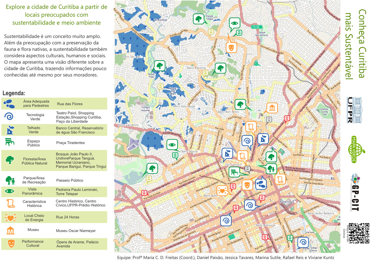
- Conheça Curitiba mais Sustentável
- Subject
- Recreation areas, Parks, Museums, Sustainable living, Sustainable buildings, and Neighborhoods
- Contributor
- Paixão, Daniel, Reis, Rafael, Kuntz, Viviane, Freitas, Maria C. D., Tavares, Jessica, and Sutile, Marina
- Publisher
- Green Map System
- Language
- por
- Date created
- 2014
- Rights Statement
- In Copyright - Educational Use Permitted
- Resource Type
- Still Image
- Extent
- 1 map : colour
- Geographic Coverage
- Brazil--Curitiba
- Coordinates
- -25.42778, -49.27306
- Chronological Coverage
- 2014
- Collection
- International Green Maps
- Provenance
- Digital files provided by Green Map System, New York, NY.
- Provider
- University of Victoria (B.C.). Library
- Genre
- maps (documents)
- Date Digitized
- 2014-07-16
- Technical Note
- Adobe PDF. Received in digital format. Metadata by PD and MT.
- Keyword in Context
- Untitled-1 Bairro Rebouças Bairro Mercês Bairro Pilarzinho Bairro Bom Retiro São Francisco Centro Bairro Jardim Botânico Bairro Prado Velho Bairro Batel Bairro Vista Alegre Bairro Cascatinha Bairro São João Vila Torres BR-277 PR-092 BR-116 A v e n ida N...