Search
Search Constraints
Start Over Filtering by: Collection International Green Maps ✖ Remove constraint Collection: International Green Maps
« Previous |
1 - 10 of 71
|
Next »
Number of results to display per page
Search Results
-

- Alternative Title
- Philadelphus Green Map, Wakulla Green Map, Red Banks Green Map, Maxton Green Map, Pembroke Green Map, Alma Green Map, and Red Springs Green Map
- Subject
- Recreation areas, Recycling (Waste, etc.), Farmers' markets, Parks, Community centers, Gardens, Cycling, Sewage, Plants, Water treatment plants--Waste disposal, and Environmental education
- Creator
- Robeson County Green Map Project
- Contributor
- Robeson County Green Map Project
- Publisher
- Robeson County Green Map Project
- Language
- eng
- Rights Statement
- In Copyright - Educational Use Permitted
- Resource Type
- Text
- Identifier
- Green Map System Number: US85
- Extent
- 1 map : colour ; 35 x 21 cm
- Geographic Coverage
- North Carolina--Pembroke, United States, North Carolina--Alma, North Carolina--Red Banks, North Carolina--Robeson County, North Carolina--Wakulla, North Carolina--Maxton, North Carolina--Philadelphus, and North Carolina--Red Springs
- Coordinates
- 34.70294, -79.25087, 34.75905, -79.17142, 34.73516, -79.34893, 34.72377, -79.31254, 34.64009, -79.10353, 34.68016, -79.19504, 34.79266, -79.25504, 39.76, -98.5, and 34.81516, -79.18309
- Collection
- International Green Maps
- Provenance
- Digital files provided by Green Map System, New York, NY.
- Provider
- University of Victoria (B.C.). Library
- Genre
- maps (documents)
- Date Digitized
- 2004-05-06
- Technical Note
- 200 dpi TIFF. Received in digital format. Metadata by PD and MT.
-
- Alternative Title
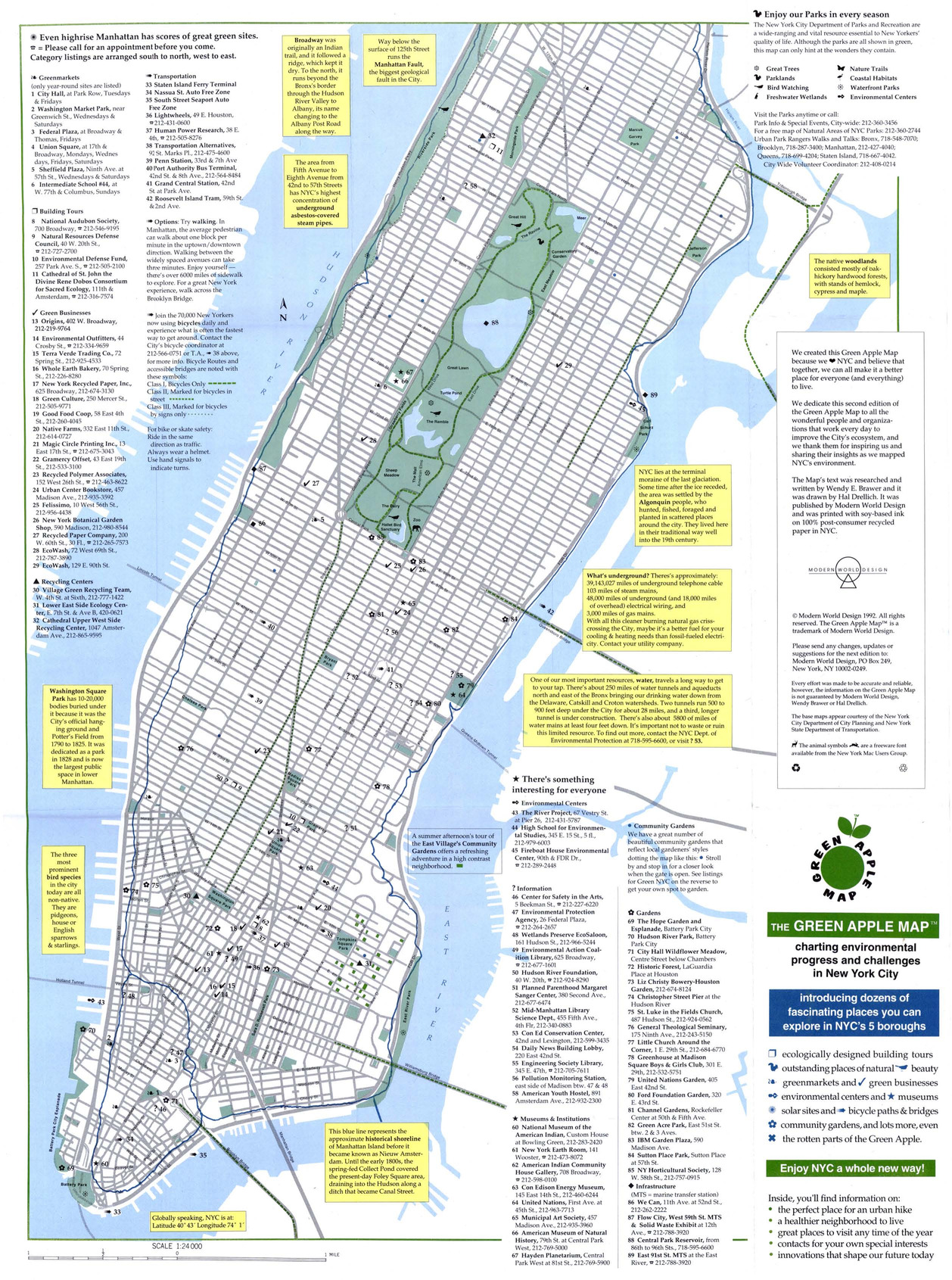
- Green Map NYC
- Subject
- Sustainable buildings, Zoos, Refuse and refuse disposal, Local transit, Recycling (Waste, etc.), Farmers' markets, Sustainable living, Community gardens, and Museums
- Creator
- Drelich, Hal
- Contributor
- Brawer, Wendy E.
- Publisher
- Modern World Design
- Language
- eng
- Date created
- 1994
- Rights Statement
- In Copyright - Educational Use Permitted
- Resource Type
- Still Image
- Identifier
- Green Map System Number: US1
- Extent
- 1 map : colour ; 43 x 27 cm
- Edition
- 2nd edition
- Geographic Coverage
- New York (State)--New York and United States
- Coordinates
- 40.71427, -74.00597 and 39.76, -98.5
- Chronological Coverage
- 1992
- Collection
- International Green Maps
- Provenance
- Digital files provided by Green Map System, New York, NY.
- Provider
- University of Victoria (B.C.). Library
- Genre
- maps (documents)
- Date Digitized
- 2007-06-11
- Technical Note
- Adobe PDF. Received in digital format. Metadata by PD and MT.
-

- Subject
- Parks, Water treatment plants--Waste disposal, Water--Purification, Recycling (Waste, etc.), Natural areas, Habitat (Ecology), Sewage, Local transit, Compost, Natural foods, Environmental management, Museums, and Farmers' markets
- Creator
- Miller, Gayle
- Publisher
- Mid-Michigan Green Map
- Language
- eng
- Date created
- 1995
- Rights Statement
- In Copyright - Educational Use Permitted
- Resource Type
- Text
- Identifier
- Green Map System Number: US31
- Extent
- 1 map : colour ; 62 x 47 cm
- Geographic Coverage
- Michigan--Eaton County, Michigan--Shiawassee County, Michigan--Ingham County, Michigan--Ionia County, United States, Michigan, and Michigan--Clinton County
- Coordinates
- 44.25029, -85.50033, 42.5971, -84.37354, 42.94509, -85.0746, 42.95373, -84.14673, 42.59607, -84.83831, 39.76, -98.5, and 42.94365, -84.60152
- Chronological Coverage
- 1995
- Collection
- International Green Maps
- Provenance
- Digital files provided by Green Map System, New York, NY.
- Provider
- University of Victoria (B.C.). Library
- Genre
- maps (documents)
- Date Digitized
- 2007-06-19
- Technical Note
- Adobe PDF. Received in digital format. Metadata by PD and MT.
-
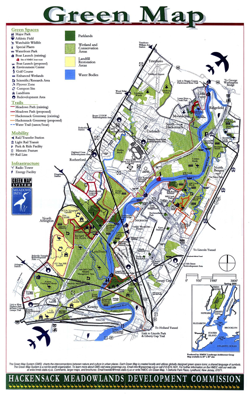
- Subject
- Wetland conservation
- Creator
- Sabatino, Mimi
- Contributor
- Hackensack Meadowlands Development Commission
- Publisher
- Modern World Design
- Language
- eng
- Date created
- 1996
- Rights Statement
- In Copyright - Educational Use Permitted
- Resource Type
- Still Image
- Identifier
- Green Map System Number: US33
- Extent
- 1 map : colour ; 27 x 43 cm
- Geographic Coverage
- United States--Hackensack River, United States, New Jersey--Hackensack Meadowlands, and New Jersey--Hackensack
- Coordinates
- 40.71316, -74.11292, 40.88593, -74.04347, 39.76, -98.5, and 40.81343, -74.04181
- Chronological Coverage
- 1996
- Collection
- International Green Maps
- Provenance
- Digital files provided by Green Map System, New York, NY.
- Provider
- University of Victoria (B.C.). Library
- Genre
- maps (documents)
- Date Digitized
- 2007-06-19
- Technical Note
- Adobe PDF. Received in digital format. Metadata by PD and MT.
-

- Subject
- Farmers' markets, Museums, Trees, Local transit, Shrines, Wetlands, Gardens, Japanese, Cycling, Forests and forestry, Sustainable buildings, Water--Purification, Thrift shops, and Environmental education
- Creator
- Tennen Design Forum
- Language
- jpn and eng
- Date created
- 1997
- Rights Statement
- In Copyright - Educational Use Permitted
- Resource Type
- Text
- Identifier
- Green Map System Number: JP23
- Extent
- 1 map : colour ; 59 x 42 cm
- Edition
- 1st edition
- Geographic Coverage
- Japan--Kyoto
- Coordinates
- 35.02107, 135.75385
- Chronological Coverage
- 1997
- Collection
- International Green Maps
- Provenance
- Digital files provided by Green Map System, New York, NY.
- Provider
- University of Victoria (B.C.). Library
- Genre
- maps (documents)
- Date Digitized
- 2007-06-07
- Technical Note
- Adobe PDF. Received in digital format. Metadata by PD and MT.
-

- Subject
- Community gardens, Parks, and Recycling (Waste, etc.)
- Creator
- Architects, Designers, Planners for Social Responsibility. Northern California Chapter
- Contributor
- Garcia, Carol, Novik, Linda, Lytle, Jacqueline, Van Mechelen, Greg, Smith, Kathleen, and Merola, Linda
- Publisher
- Inkworks Press
- Language
- eng
- Date created
- 1998
- Rights Statement
- In Copyright - Educational Use Permitted
- Resource Type
- Still Image
- Identifier
- Green Map System Number: US19
- Extent
- 1 map : colour ; 27 x 43 cm
- Geographic Coverage
- California--Berkeley and United States
- Coordinates
- 39.76, -98.5 and 37.87159, -122.27275
- Chronological Coverage
- 1998
- Collection
- International Green Maps
- Provenance
- Digital files provided by Green Map System, New York, NY.
- Provider
- University of Victoria (B.C.). Library
- Genre
- maps (documents)
- Date Digitized
- 2007-06-11
- Technical Note
- Adobe PDF. Received in digital format. Metadata by PD and MT.
-

- Subject
- Refuse and refuse disposal, Recycling (Waste, etc.), Recycling (Waste, etc.)--Environmental aspects, Refuse and refuse disposal--Environmental aspects, Recycling (Waste, etc.)--Planning, and Recycling (Waste, etc.)--Citizen participation
- Creator
- Nowakowski, Kamil, Rodriguez, Amanda, Garzon, Jose, Almeida, David, Fonseca, Christine, Perez, Jason, Falcon, Keith, Walker, Nairobi, and Chia, Norma
- Contributor
- Recycle-A-Bicycle
- Publisher
- Green Map System
- Language
- eng
- Date created
- 1999?
- Rights Statement
- In Copyright - Educational Use Permitted
- Resource Type
- Still Image
- Identifier
- Green Map System Number: US12
- Extent
- 1 map : colour ; 27 x 43 cm
- Geographic Coverage
- New York (State)--New York and United States
- Coordinates
- 40.71427, -74.00597 and 39.76, -98.5
- Chronological Coverage
- 2000
- Collection
- International Green Maps
- Provenance
- Digital files provided by Green Map System, New York, NY.
- Provider
- University of Victoria (B.C.). Library
- Genre
- maps (documents)
- Date Digitized
- 2012-01-09
- Technical Note
- Adobe PDF. Received in digital format. Metadata by PD and MT.
-

- Alternative Title
- Green Bike Map of North Brabant
- Subject
- Cycling
- Creator
- Regionaal Overleg Natuur-en Milieucommunicatie Noord-Brabant
- Contributor
- Foks, Renate and Ad Vermeulen
- Publisher
- Drukkerij Damen (Werkendam)
- Language
- dut
- Date created
- 1999
- Rights Statement
- In Copyright - Educational Use Permitted
- Resource Type
- Still Image
- Identifier
- Green Map System Number: EU19
- Extent
- 1 map : colour ; 59 x 41 cm
- Geographic Coverage
- Netherlands--North Brabant
- Coordinates
- 51.44083, 5.47778
- Chronological Coverage
- 1999
- Collection
- International Green Maps
- Provenance
- Digital files provided by Green Map System, New York, NY.
- Provider
- University of Victoria (B.C.). Library
- Genre
- maps (documents)
- Date Digitized
- 2007-06-11
- Technical Note
- Adobe PDF. Received in digital format. Metadata by PD and MT.
-

- Alternative Title
- Discover Malmö the green way, Upptäck Malmös gröna sidor, and Malmo Green Map
- Subject
- Sustainable living, Recycling (Waste, etc.)--Citizen participation, Organic farming, Sustainable urban development, Recycling (Waste, etc.), and Local transit
- Creator
- Richter, Bengt-Arne and Fossum, Tor
- Contributor
- Dolocek, John, Gothrick, Hans-Lennart, and Kunskap Malmo
- Publisher
- Malmö Green Map
- Language
- eng and swe
- Date created
- 1999
- Rights Statement
- In Copyright - Educational Use Permitted
- Resource Type
- Still Image
- Identifier
- Green Map System Number: EU17
- Extent
- 1 map : colour ; 59 x 41 cm
- Edition
- 2nd edition
- Geographic Coverage
- Sweden--Malmö
- Coordinates
- 57.81667, 16.7
- Chronological Coverage
- 1999
- Collection
- International Green Maps
- Provenance
- Digital files provided by Green Map System, New York, NY.
- Provider
- University of Victoria (B.C.). Library
- Genre
- maps (documents)
- Date Digitized
- 2007-06-11
- Technical Note
- Adobe PDF. Received in digital format. Metadata by PD and MT.
-
- Subject
- Renewable energy sources, Watersheds, Culture, Thrift shops, Environmental education, Farmers' markets, Cycling, Natural areas, Wildlife conservation, Community gardens, Population--Statistics, Parks, Fair trade foods, Open spaces, Local transit, Animals, and Recycling (Waste, etc.)
- Creator
- Milwaukee Green Map Project
- Contributor
- Groshek, Matthew
- Publisher
- Sells Printing Co.
- Language
- eng
- Date created
- 1999
- Rights Statement
- In Copyright - Educational Use Permitted
- Resource Type
- Still Image
- Identifier
- Green Map System Number: US52
- Extent
- 1 map : colour ; 86 x 55 cm
- Geographic Coverage
- Wisconsin--Milwaukee and United States
- Coordinates
- 39.76, -98.5 and 43.0389, -87.90647
- Chronological Coverage
- 1999
- Collection
- International Green Maps
- Provenance
- Digital files provided by Green Map System, New York, NY.
- Provider
- University of Victoria (B.C.). Library
- Genre
- maps (documents)
- Date Digitized
- 2007-06-11
- Technical Note
- Adobe PDF. Received in digital format. Metadata by PD and MT.