Search
Search Constraints
Start Over Filtering by: Collections British Columbia Historical Maps ✖ Remove constraint Collections: British Columbia Historical Maps
Number of results to display per page
Search Results
-
- Language
- eng
- Rights Statement
- No Copyright - Contractual restrictions
- Resource Type
- Still Image
- Identifier
- H1/1 fo. 6
- Extent
- 1 sheet
- Geographic Coverage
- British Columbia--Saanich and British Columbia--Victoria
- Coordinates
- 48.54964, -123.36931 and 48.4359, -123.35155
- Additional Physical Characteristics
- 1:10,560
- Physical Repository
- Hudson's Bay Company. Archives
- Collection
- Early B.C. Maps from the Hudson's Bay Company Archives
- Provider
- University of Victoria (B.C.). Library
- Genre
- historical maps and maps (documents)
- Date Digitized
- 2013-05-10
- Transcript
- 6 inches:1 mile
-
Victoria Fire Insurance Plans
User Collection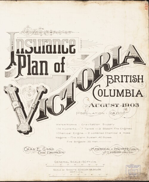 1Collections5Works
- Description:
- The Fire Insurance Plans (FIPs) from 1885 to 1916 are undoubtedly the best maps of Victoria for the period. Created by Charles E. Goad and Company to assist insurance underwriters in determining fire insurance risk these coloured maps show the developing...
- Subject
- Local History and Architecture
- Location
- Victoria, British Columbia, Canada
- Resource Type
- Collection
- Genre
- maps (documents) and historical maps
-
- Language
- eng
- Rights Statement
- No Copyright - Contractual restrictions
- Resource Type
- Still Image
- Identifier
- G1/252
- Extent
- 1 sheet
- Geographic Coverage
- British Columbia--Victoria
- Coordinates
- 48.4359, -123.35155
- Physical Repository
- Hudson's Bay Company. Archives
- Collection
- Early B.C. Maps from the Hudson's Bay Company Archives
- Provider
- University of Victoria (B.C.). Library
- Genre
- maps (documents) and historical maps
- Date Digitized
- 2013-05-10
-
- Alternative Title
- Indian Reserve 23, New Westminster District
- Subject
- Land titles, Land use, Land cover, Indian reservations, Indigenous peoples, and Land titles--Maps
- Creator
- Surveyor General of British Columbia
- Language
- eng
- Rights Statement
- No Copyright - Non-Commercial Use Only
- Resource Type
- Still Image
- Identifier
- New Westminster 23, LTSA Inventory No.: LTSA6172, Plan Number: 23TR-IR (New Westminster), LTSA SGD Microfilm Image Number: 106444, and Plan Barcode: Z0366441
- Extent
- 1 sheet
- Geographic Coverage
- British Columbia--Metro Vancouver Regional District and British Columbia--Indian Arm
- Coordinates
- 49.36637, -122.88593 and 49.46637, -122.88594
- Additional Physical Characteristics
- Scale: 1 inch = 40 chains
- Physical Repository
- Land Title and Survey Authority of British Columbia
- Collection
- Land Title and Survey Authority of British Columbia: Indian Reserve Maps
- Provider
- University of Victoria (B.C.). Library
- Genre
- historical maps, maps (documents), and land surveys
- Technical Note
- Cataloguing metadata: Provided by the LTSA and adapted by University of Victoria Libraries to their requirements.
-
- Subject
- Land titles--Maps, Indian reservations, Land use, Indigenous peoples, Land titles, and Land cover
- Creator
- Surveyor General of British Columbia
- Language
- eng
- Rights Statement
- No Copyright - Non-Commercial Use Only
- Resource Type
- Still Image
- Identifier
- Plan Number: 38TR-1A-IR, LTSA SGD Microfilm Image Number: 106570 (2 of 3), LTSA Inventory No.: LTSA6178, and Plan Barcode: Z0366620
- Extent
- 1 sheet
- Geographic Coverage
- British Columbia--Maple Ridge--Whonnock, British Columbia--Matsqui Island, and British Columbia--Fraser River
- Coordinates
- 49.16637, -122.4693, 48.99967, -122.46928, 49.11637, -122.35258, and 49.19967, -122.66931
- Additional Physical Characteristics
- Scale: 2 inches = 1 mile
- Physical Repository
- Land Title and Survey Authority of British Columbia
- Collection
- Land Title and Survey Authority of British Columbia: Indian Reserve Maps
- Provider
- University of Victoria (B.C.). Library
- Genre
- land surveys, historical maps, and maps (documents)
- Technical Note
- Cataloguing metadata: Provided by the LTSA and adapted by University of Victoria Libraries to their requirements.
-
- Subject
- Land cover, Indigenous peoples, Indian reservations, Land titles, Land titles--Maps, Burial, and Land use
- Creator
- Surveyor General of British Columbia
- Language
- eng
- Rights Statement
- No Copyright - Non-Commercial Use Only
- Resource Type
- Still Image
- Identifier
- LTSA Inventory No.: LTSA6178, LTSA SGD Microfilm Image Number: 106594, Plan Barcode: Z0366619, and Plan Number: 37TR-1A-IR
- Extent
- 1 sheet
- Geographic Coverage
- British Columbia--Nass River, British Columbia--Ksga'maal (stream), and British Columbia--Kitimat-Stikine
- Coordinates
- 55.21344, -129.15367, 55.33289, -129.00362, and 54.9916, -129.84509
- Additional Physical Characteristics
- Scale: 2 inches = 1 mile
- Physical Repository
- Land Title and Survey Authority of British Columbia
- Collection
- Land Title and Survey Authority of British Columbia: Indian Reserve Maps
- Provider
- University of Victoria (B.C.). Library
- Genre
- land surveys, maps (documents), and historical maps
- Technical Note
- Cataloguing metadata: Provided by the LTSA and adapted by University of Victoria Libraries to their requirements.
-
- Alternative Title
- Bonaparte Indians
- Subject
- Indigenous peoples, Land use, Indian reservations, Land cover, Burial, Land titles--Maps, and Land titles
- Creator
- Surveyor General of British Columbia
- Language
- eng
- Rights Statement
- No Copyright - Non-Commercial Use Only
- Resource Type
- Still Image
- Identifier
- Kamloops 29, LTSA SGD Microfilm Image Number: 106460, Plan Barcode: Z0366379, LTSA Inventory No.: LTSA6169, and Plan Number: 29TR-IR (Kamloops)
- Extent
- 1 sheet
- Geographic Coverage
- British Columbia--Bonaparte River and British Columbia--Thompson-Nicola Regional District
- Coordinates
- 50.84977, -121.36931
- Additional Physical Characteristics
- Scale: 1 inch = 40 chains
- Physical Repository
- Land Title and Survey Authority of British Columbia
- Collection
- Land Title and Survey Authority of British Columbia: Indian Reserve Maps
- Provider
- University of Victoria (B.C.). Library
- Genre
- land surveys, historical maps, and maps (documents)
- Technical Note
- Cataloguing metadata: Provided by the LTSA and adapted by University of Victoria Libraries to their requirements.
-
- Alternative Title
- Bonaparte Indians and Plan of the Ashcroft Indian Reserves, Yale District
- Subject
- Land titles--Maps, Land use, Burial, Land titles, Indian reservations, Land cover, and Indigenous peoples
- Creator
- Surveyor General of British Columbia
- Language
- eng
- Rights Statement
- No Copyright - Non-Commercial Use Only
- Resource Type
- Still Image
- Identifier
- LTSA Inventory No.: LTSA6169, Kamloops 29, Plan Barcode: Z0366584, Plan Number: 29TR-IR (tracing) (Kamloops), and LTSA SGD Microfilm Image Number: no number
- Extent
- 1 sheet
- Geographic Coverage
- British Columbia--Bonaparte River and British Columbia--Thompson-Nicola Regional District
- Coordinates
- 50.84977, -121.36931
- Additional Physical Characteristics
- Scale: 1 inch = 40 chains
- Physical Repository
- Land Title and Survey Authority of British Columbia
- Collection
- Land Title and Survey Authority of British Columbia: Indian Reserve Maps
- Provider
- University of Victoria (B.C.). Library
- Genre
- maps (documents), land surveys, and historical maps
- Technical Note
- Cataloguing metadata: Provided by the LTSA and adapted by University of Victoria Libraries to their requirements.
-
- Alternative Title
- Indian Reserves Chemainis.
- Subject
- Land use, Land titles--Maps, Land cover, Land titles, Indian reservations, and Indigenous peoples
- Creator
- Surveyor General of British Columbia
- Language
- eng
- Rights Statement
- No Copyright - Non-Commercial Use Only
- Resource Type
- Still Image
- Identifier
- Plan Number: 09TR-IR (original) (Vancouver Island), Plan Barcode: Z0366471, LTSA SGD Microfilm Image Number: 106479/106480, and LTSA Inventory No.: LTSA6175
- Extent
- 1 sheet
- Geographic Coverage
- British Columbia--Chemainus Land District, British Columbia--Chemainus River, British Columbia--Willy Island, and British Columbia--Cowichan Valley
- Coordinates
- 48.90089, -123.66816, 48.89964, -123.7777, and 48.89963, -123.68597
- Additional Physical Characteristics
- Scale: 1 inch = 10 chains
- Physical Repository
- Land Title and Survey Authority of British Columbia
- Collection
- Land Title and Survey Authority of British Columbia: Indian Reserve Maps
- Provider
- University of Victoria (B.C.). Library
- Genre
- maps (documents), historical maps, and land surveys
- Technical Note
- Cataloguing metadata: Provided by the LTSA and adapted by University of Victoria Libraries to their requirements.
-
- Alternative Title
- Indian Reserves Chemainis.
- Subject
- Land cover, Indian reservations, Land titles--Maps, Land use, Indigenous peoples, and Land titles
- Creator
- Surveyor General of British Columbia
- Language
- eng
- Rights Statement
- No Copyright - Non-Commercial Use Only
- Resource Type
- Still Image
- Identifier
- LTSA Inventory No.: LTSA6175, LTSA SGD Microfilm Image Number: 106477, Plan Barcode: Z0366470, and Plan Number: 09TR-IR (tracing) (Vancouver Island)
- Extent
- 1 sheet
- Geographic Coverage
- British Columbia--Cowichan Valley, British Columbia--Chemainus River, British Columbia--Willy Island, and British Columbia--Chemainus Land District
- Coordinates
- 48.90089, -123.66816, 48.89964, -123.7777, and 48.89963, -123.68597
- Additional Physical Characteristics
- Scale: 1 inch = 10 chains
- Physical Repository
- Land Title and Survey Authority of British Columbia
- Collection
- Land Title and Survey Authority of British Columbia: Indian Reserve Maps
- Provider
- University of Victoria (B.C.). Library
- Genre
- maps (documents), historical maps, and land surveys
- Technical Note
- Cataloguing metadata: Provided by the LTSA and adapted by University of Victoria Libraries to their requirements.