Search
Search Constraints
Start Over Filtering by: Subject Outdoor recreation ✖ Remove constraint Subject: Outdoor recreation
« Previous |
1 - 10 of 11
|
Next »
Number of results to display per page
Search Results
1. Archie Wills - YMCA Camp photograph album, 1911-1916

- Subject:
- Wills, Archie H. (Archibald Henry), 1892-1988, Young men, Camps, Outdoor recreation, and Young Men's Christian associations
- Language:
- eng
- Date Created:
- 1911 to 1916
- Rights Statement:
- In Copyright - Educational Use Permitted
- Resource Type:
- Text
- Extent:
- 108 pages
- Geographic Coverage:
- British Columbia--Victoria
- Coordinates:
- 48.4359, -123.35155
- Physical Repository:
- University of Victoria (B.C.). Library
- Collection:
- Victoria to Vimy First World War Collection
- Provider:
- University of Victoria (B.C.). Library
- Genre:
- photographs, photograph albums, clippings (information artifacts), and black-and-white photographs
- Fonds Title:
- Archie H. Wills fonds
- Fonds Identifier:
- AR394
- Is Referenced By:
- Archival Finding Aid: https://uvic2.coppul.archivematica.org/archie-h-wills-fonds
- Technical Note:
- Migration metadata by KD.
2. Calgary Green Map 2000-2001

- Subject:
- Wetlands, Parks, Recreation areas, Remote-sensing images, Natural areas, and Outdoor recreation
- Creator:
- Sustainable Calgary
- Contributor:
- Canada Millennium Partnership Program
- Publisher:
- City of Calgary
- Language:
- eng
- Date Created:
- 2000
- Rights Statement:
- In Copyright - Educational Use Permitted
- Resource Type:
- Still Image
- Identifier:
- Green Map System Number: CA16
- Extent:
- 1 map : colour ; 83 x 59 cm
- Geographic Coverage:
- Alberta--Calgary
- Coordinates:
- 51.05011, -114.08529
- Chronological Coverage:
- 2000/2001
- Collection:
- International Green Maps
- Provenance:
- Digital files provided by Green Map System, New York, NY.
- Provider:
- University of Victoria (B.C.). Library
- Genre:
- maps (documents) and satellite imagery
- Date Digitized:
- 2007-05-19
- Technical Note:
- Adobe PDF. Received in digital format. Metadata by PD and MT.
3. Nishinomiya Green Map

- Subject:
- Plants, Parks, Outdoor recreation, Trees, Community centers, Recycling (Waste, etc.), Museums, and Recreation areas
- Creator:
- Nishinomiya-Kofu Senior High School
- Language:
- jpn
- Date Created:
- 2002
- Rights Statement:
- In Copyright - Educational Use Permitted
- Resource Type:
- Still Image
- Identifier:
- Green Map System Number: JP24
- Extent:
- 1 map : colour ; 41 x 29 cm
- Geographic Coverage:
- Japan--Nishinomiya-shi
- Coordinates:
- 34.78194, 135.30247
- Chronological Coverage:
- 2002
- Collection:
- International Green Maps
- Provenance:
- Digital files provided by Green Map System, New York, NY.
- Provider:
- University of Victoria (B.C.). Library
- Genre:
- maps (documents)
- Date Digitized:
- 2007-06-07
- Technical Note:
- Adobe PDF. Received in digital format. Metadata by PD and MT.
4. Green Map of Toyota City

- Subject:
- Outdoor recreation, Local transit, Recreation areas, and Biodiversity
- Creator:
- Toyota City Green Map, Aichi
- Contributor:
- Toyota Seinen Kaigisho (Junior Chamber International Toyota)
- Publisher:
- Past Mapmakers
- Language:
- jpn
- Date Created:
- 2003
- Rights Statement:
- In Copyright - Educational Use Permitted
- Resource Type:
- Text
- Identifier:
- Green Map System Number: JP30
- Extent:
- 1 map : colour ; 41 x 57 cm
- Geographic Coverage:
- Japan--Toyota-shi
- Coordinates:
- 35.087, 137.15
- Chronological Coverage:
- 2003
- Collection:
- International Green Maps
- Provenance:
- Digital files provided by Green Map System, New York, NY.
- Provider:
- University of Victoria (B.C.). Library
- Genre:
- maps (documents)
- Date Digitized:
- 2004-06-23
- Technical Note:
- 300 dpi TIFF. Born digital resource. Metadata by PD and MT.
5. Niigata pref. Kenoh Greenmap

- Alternative Title:
- Kenoh Green Map, Tsubame-Sanjo, Nigata Pref. and Niigata prefecture Kenoh Green Map
- Subject:
- Neighborhoods, Museums, Outdoor recreation, Recreation areas, Plants, Trees, Wildlife conservation, and Parks
- Creator:
- Yokoki, Hiroyuki
- Publisher:
- Tsubame-Sanjo Junior Chamber of Commerce
- Language:
- jpn
- Date Created:
- 2003
- Rights Statement:
- In Copyright - Educational Use Permitted
- Resource Type:
- Text
- Identifier:
- Green Map System Number: JP32
- Extent:
- 1 map : colour ; 58 x 41 cm
- Geographic Coverage:
- Japan--Tagami-machi, Japan--Teradomari-machi, Japan--Sanjō-shi, Japan--Niigata-ken, and Japan--Tsubame-shi
- Coordinates:
- 37.61667, 138.95, 37.69828, 139.06947, 37.52343, 138.91748, 37.6645, 138.92518, and 37.58333, 138.73333
- Chronological Coverage:
- 2003
- Collection:
- International Green Maps
- Provenance:
- Digital files provided by Green Map System, New York, NY.
- Provider:
- University of Victoria (B.C.). Library
- Genre:
- maps (documents)
- Date Digitized:
- 2004-06-23
- Technical Note:
- 300 dpi TIFF. Born digital resource. Metadata by PD and MT.
6. Other map of Toronto: your gateway to nature culture & urban adventure

- Alternative Title:
- Welcome to a green Toronto, The Living City: Experience nature in the Toronto Region, and The City Alive: Discover the true nature of Downtown Toronto
- Subject:
- Outdoor recreation--Environmental aspects, Green marketing, Outdoor recreation, Environmental conditions, and Tourist maps
- Creator:
- CO2 Creative (Firm)
- Contributor:
- Ontario Trillium Foundation, Toronto (Ont.). Urban Development Services, Tourism Toronto, and Toronto and Region Conservation for the Living City
- Publisher:
- Green Tourism Association
- Language:
- eng
- Date Created:
- 2003
- Rights Statement:
- In Copyright - Educational Use Permitted
- Resource Type:
- Text
- Identifier:
- Call Number: G3464 T7E635 2003 C6 and Green Map System Number: CA3
- Extent:
- 1 map : colour ; 91 x 66 cm
- Edition:
- 2nd edition
- Geographic Coverage:
- Canada, Ontario--Toronto Region, and Ontario--Toronto
- Coordinates:
- 43.70011, -79.4163, 60.10867, -113.64258, and 43.75919, -79.26636
- Chronological Coverage:
- 2003
- Additional Physical Characteristics:
- Scale: ca. 1:50,000
- Collection:
- International Green Maps
- Provenance:
- Digital files provided by Green Map System, New York, NY.
- Provider:
- University of Victoria (B.C.). Library
- Genre:
- maps (documents)
- Date Digitized:
- 2004-06-23
- Technical Note:
- 300 dpi TIFF. Born digital resource. Metadata by PD and MT.
7. Green Map Flushing Meadow Queens NY

- Subject:
- Recycling (Waste, etc.), Community gardens, Cycling, Neighborhoods, Culture, Animals, Trees, Parks, Older people, Farmers' markets, Community centers, Outdoor recreation, and Local transit
- Creator:
- Green Map System (Firm)
- Contributor:
- Green Map System (Firm)
- Publisher:
- Green Map System
- Language:
- eng
- Date Created:
- 2005
- Rights Statement:
- In Copyright - Educational Use Permitted
- Resource Type:
- Still Image
- Identifier:
- Green Map System Number: US102
- Extent:
- 1 map : colour
- Geographic Coverage:
- United States and New York (State)--New York--Flushing Meadows-Corona Park
- Coordinates:
- 39.76, -98.5 and 40.7401, -73.84069
- Chronological Coverage:
- 2005
- Collection:
- International Green Maps
- Provenance:
- Digital files provided by Green Map System, New York, NY.
- Provider:
- University of Victoria (B.C.). Library
- Genre:
- maps (documents)
- Date Digitized:
- 2012-01-07
- Technical Note:
- 72 dpi JPG. Received in digital format. Metadata by PD and MT.
8. Burlington/South Burlington bicycle map with information on mass transit, recreational areas, environmental sites, and points of interest
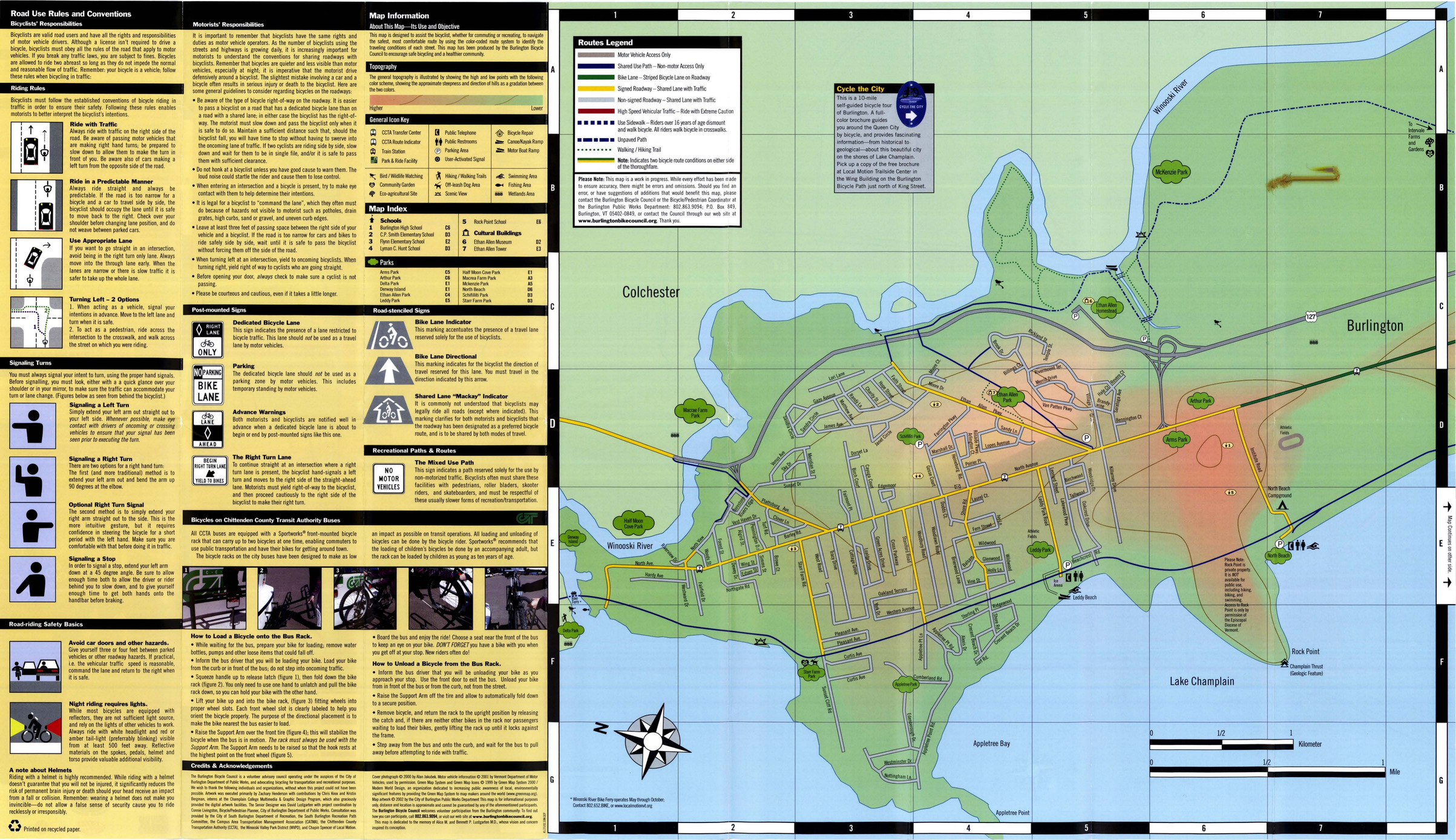
- Subject:
- Bicycle commuting, Local transit, Bicycle commuting--Safety measures, Cycling, Outdoor recreation, and Recreation areas
- Creator:
- Burlington Bicycle Council
- Contributor:
- Lustgarten, David
- Publisher:
- Burlington Public Works
- Language:
- eng
- Date Created:
- 2007
- Rights Statement:
- In Copyright - Educational Use Permitted
- Resource Type:
- Still Image
- Identifier:
- Green Map System Number: US87
- Extent:
- 1 map : colour ; 80 x 47 cm
- Geographic Coverage:
- United States and Vermont--Burlington
- Coordinates:
- 44.47588, -73.21207 and 39.76, -98.5
- Chronological Coverage:
- 2000/2007
- Collection:
- International Green Maps
- Provenance:
- Digital files provided by Green Map System, New York, NY.
- Provider:
- University of Victoria (B.C.). Library
- Genre:
- maps (documents)
- Date Digitized:
- 2007-06-19
- Technical Note:
- Adobe PDF. Received in digital format. Metadata by PD and MT.
9. Peninsula Parks and Play Spaces: A Community Green Map

- Alternative Title:
- Peninsula parks & play spaces
- Subject:
- Recreation, Playgrounds, and Outdoor recreation
- Creator:
- Peninsula Connections for Early Childhood
- Contributor:
- Josephson, Ken, Common Ground Community Mapping Project, and Burnett, Charles
- Publisher:
- Green Map System (Firm)
- Language:
- eng
- Date Created:
- 2007
- Rights Statement:
- In Copyright - Educational Use Permitted
- Resource Type:
- Text
- Identifier:
- Call Number: G3514 V5E63 2007 P4
- Extent:
- 1 map on 2 sheets : colour ; 61 x 45 cm
- Geographic Coverage:
- British Columbia--Victoria Region and British Columbia--Saanich Peninsula
- Coordinates:
- 48.53294, -123.41931 and 48.4359, -123.35155
- Chronological Coverage:
- 2006
- Additional Physical Characteristics:
- Scale: ca. 1:30000
- Collection:
- Community Mapping Project
- Provenance:
- Digital files provided by University of Victoria Department of Geography.
- Provider:
- University of Victoria (B.C.). Library
- Genre:
- cadastral maps and maps (documents)
- Date Digitized:
- 2016-02-15
- Technical Note:
- 400 dpi JPG. Born digital resource. Metadata by CDW and MT.
10. Cape Town green map 4th edition: Cape Town - green by design. Find it - live it!
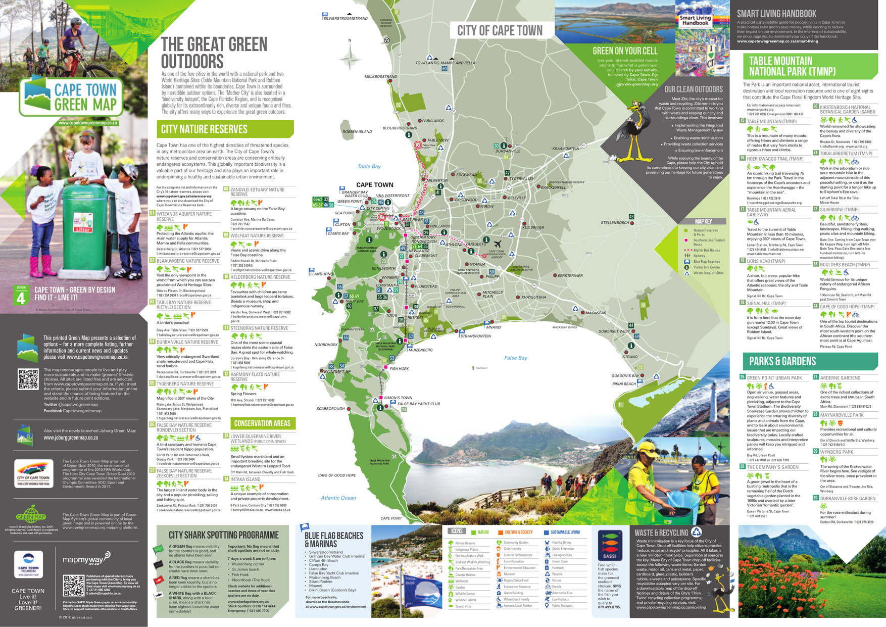
- Alternative Title:
- The great green outdoors
- Subject:
- Wetland conservation, Outdoor recreation, Watersheds, Natural areas, and Parks
- Creator:
- City of Cape Town (South Africa)
- Publisher:
- A&C Maps
- Language:
- eng
- Date Created:
- 2013
- Rights Statement:
- In Copyright - Educational Use Permitted
- Resource Type:
- Text
- Identifier:
- Green Map System Number: AF1
- Extent:
- 1 map : colour
- Edition:
- 4th edition
- Geographic Coverage:
- South Africa--Cape Town
- Coordinates:
- -33.92584, 18.42322
- Chronological Coverage:
- 2013
- Collection:
- International Green Maps
- Provenance:
- Digital files provided by Green Map System, New York, NY.
- Provider:
- University of Victoria (B.C.). Library
- Genre:
- maps (documents)
- Date Digitized:
- 2013-01-11
- Technical Note:
- Adobe PDF. Received in digital format. Metadata by PD and MT.
- Keyword in Context:
- This printed Green Map presents a selection of options – for a more complete listing, further information and current news and updates please visit www.capetowngreenmap.co.za Printed on SAPPI Triple Green paper, an environmentally- friendly paper stock made from chlor...