Search
Search Constraints
Start Over Filtering by: Subject Public art ✖ Remove constraint Subject: Public art
1 - 10 of 10
Number of results to display per page
Search Results
1. LoMap: charting Lower Manhattan's environment as seen by youth
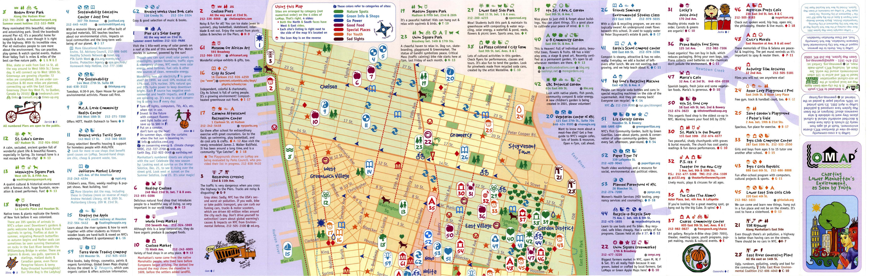
- Alternative Title:
- LoMap: explore downtown's environment as guided by youth
- Subject:
- Libraries, Public art, Farmers' markets, Community centers, Museums, Recycling (Waste, etc.), Air--Pollution, Local transit, Recreation centers, Thrift shops, Voluntarism, Culture, Animals, Parks, Recreation areas, Renewable energy sources, Community gardens, and Plants
- Creator:
- Green Map System (Firm)
- Contributor:
- Kline, Diana Signe, Ferguson, Beth, and Brawer, Wendy E.
- Publisher:
- New York Recycled Paper Inc.
- Language:
- eng
- Date Created:
- 2000
- Rights Statement:
- In Copyright - Educational Use Permitted
- Resource Type:
- Still Image
- Identifier:
- Green Map System Number: US3
- Extent:
- 1 map : colour ; 94 x 30 cm
- Geographic Coverage:
- New York (State)--New York--Manhattan, New York (State), and United States
- Coordinates:
- 40.78343, -73.96625, 40.71427, -74.00597, and 39.76, -98.5
- Chronological Coverage:
- 2000
- Collection:
- International Green Maps
- Provenance:
- Digital files provided by Green Map System, New York, NY.
- Provider:
- University of Victoria (B.C.). Library
- Genre:
- maps (documents)
- Date Digitized:
- 2007-06-11
- Technical Note:
- Adobe PDF. Received in digital format. Metadata by PD and MT.
2. Melbourne Green Map

- Subject:
- Trees, Sustainable buildings, Sewage disposal plants, Fair trade foods, Parks, Wetlands, Culture, Wildlife conservation, Museums, Community centers, Local transit, Open spaces, Environmental education, Renewable energy sources, Community gardens, Animals, Recycling (Waste, etc.), Public art, and Farmers' markets
- Creator:
- City of Melbourne
- Contributor:
- RMIT University. Centre for Design
- Publisher:
- City of Melbourne
- Language:
- eng
- Date Created:
- 2001
- Rights Statement:
- In Copyright - Educational Use Permitted
- Resource Type:
- Still Image
- Identifier:
- Green Map System Number: AU2
- Extent:
- 1 map : colour ; 68 x 62 cm
- Geographic Coverage:
- Australia and Victoria--Melbourne
- Coordinates:
- -25, 135 and -37.814, 144.96332
- Chronological Coverage:
- 2001
- Collection:
- International Green Maps
- Provenance:
- Digital files provided by Green Map System, New York, NY.
- Provider:
- University of Victoria (B.C.). Library
- Genre:
- maps (documents)
- Date Digitized:
- 2007-06-19
- Technical Note:
- Adobe PDF. Received in digital format. Metadata by PD and MT.
3. Sabin Neighborhood greenmap

- Alternative Title:
- Sabin neighborhood greenmap: a Portland Greenmap pilot project sponsored by Nature's Northwest
- Subject:
- Public art, Cycling, Libraries, Playgrounds, Community centers, Habitat (Ecology), Parks, Natural foods, Community gardens, Thrift shops, Forests and forestry, and Environmental education
- Creator:
- Portland Greenmap
- Contributor:
- King, Jason and Kausfamann, Cathy
- Publisher:
- Portland Greenmap
- Language:
- eng
- Date Created:
- 2001
- Rights Statement:
- In Copyright - Educational Use Permitted
- Resource Type:
- Still Image
- Identifier:
- Green Map System Number: US38
- Extent:
- 1 map : colour ; 27 x 43 cm
- Geographic Coverage:
- Oregon--Portland and United States
- Coordinates:
- 45.52345, -122.67621 and 39.76, -98.5
- Chronological Coverage:
- 2001
- Collection:
- International Green Maps
- Provenance:
- Digital files provided by Green Map System, New York, NY.
- Provider:
- University of Victoria (B.C.). Library
- Genre:
- maps (documents)
- Date Digitized:
- 2007-06-19
- Technical Note:
- Adobe PDF. Received in digital format. Metadata by PD and MT.
4. Tamagawa Tri-Area Green Map

- Subject:
- Community gardens, Public art, Plants, and Archaeology
- Publisher:
- Tamagawa Tri-Area Green Map
- Language:
- jpn
- Date Created:
- 2002
- Rights Statement:
- In Copyright - Educational Use Permitted
- Resource Type:
- Text
- Identifier:
- Green Map System Number: JP28
- Extent:
- 1 map : colour ; 59 x 42 cm
- Geographic Coverage:
- Japan--Tokyo and Japan--Tama River (Yamanashi-ken-Tokyo)
- Coordinates:
- 35.6895, 139.69171 and 35.5218, 139.7983
- Chronological Coverage:
- 2002
- Collection:
- International Green Maps
- Provenance:
- Digital files provided by Green Map System, New York, NY.
- Provider:
- University of Victoria (B.C.). Library
- Genre:
- maps (documents)
- Date Digitized:
- 2019-12-11
- Technical Note:
- Adobe PDF. Received in digital format. Metadata by PD and MT.
- Keyword in Context:
- E-3 ••rn-tt*■ (-IJ'?7) .:A.t,1Jtl,f�i!.ll'7>J:t:a,9�lll1.i -+t?7'7>1E'7>�1ilt:tr-?,t �f$ff ?'t� ,e:-?� 1:a a oti.-?>. E-3 ••111aaie•11�H:t 11t83*1X:Ell1·5·1 tel:03-3701- 1679 iiiII, ,e,:..i;-?>Jt.!1'7>r =:J-�it>lf�tl{l l:'.li• m:!au t:$l,i2,&'.>1!1'f_H,. C-t ll!iR,t•J;...
5. Green map of central Pune, Maharashtra, India

- Alternative Title:
- Green Map of Pune: a historical city
- Subject:
- Parks, Wildlife conservation, Older people, Museums, Animals, Water harvesting, Community gardens, Farmers' markets, Natural monuments, Public art, Compost, and Culture
- Creator:
- Nebula Consultants (Firm)
- Publisher:
- Anand Upalekar
- Language:
- eng
- Date Created:
- 2003
- Rights Statement:
- In Copyright - Educational Use Permitted
- Resource Type:
- Still Image
- Identifier:
- Green Map System Number: AS15
- Extent:
- 1 map : colour ; 54 x 41 cm
- Geographic Coverage:
- India--Pune
- Coordinates:
- 18.51957, 73.85535
- Chronological Coverage:
- 2003
- Collection:
- International Green Maps
- Provenance:
- Digital files provided by Green Map System, New York, NY.
- Provider:
- University of Victoria (B.C.). Library
- Genre:
- maps (documents)
- Date Digitized:
- 2004-06-22
- Technical Note:
- 300 dpi TIFF. Received in digital format. Metadata by PD and MT.
6. Jhenjhu Green Map

- Alternative Title:
- 珍珠社区绿色生活地图
- Subject:
- Natural areas, Local transit, Recycling (Waste, etc.), Museums, Wetlands, Parks, Trees, Animals, Yi lan xian dong shan xiang, Public art, and Cycling
- Creator:
- Lin, Yuhuan
- Contributor:
- Development Committee of Zhenzhu Community
- Publisher:
- Taiwan Society of Wilderness
- Language:
- chi
- Date Created:
- 2003
- Rights Statement:
- In Copyright - Educational Use Permitted
- Resource Type:
- Text
- Identifier:
- Green Map System Number: TW39
- Extent:
- 1 map : colour ; 50 x 36 cm
- Geographic Coverage:
- Taiwan--Yilan County
- Coordinates:
- 46.26085, 129.70666
- Chronological Coverage:
- 2003
- Collection:
- International Green Maps
- Provenance:
- Digital files provided by Green Map System, New York, NY.
- Provider:
- University of Victoria (B.C.). Library
- Genre:
- maps (documents)
- Date Digitized:
- 2004-06-22
- Technical Note:
- 300 dpi TIFF. Born digital resource. Metadata by PD and MT.
7. Green Map Chinatown New York City

- Alternative Title:
- Mapa Verde Barrio Chino cuidad de Nueva York
- Subject:
- Neighborhoods, Renewable energy sources, Sustainable urban development, Public art, Farmers' markets, Museums, Sustainable living, Community centers, Culture, and Open spaces
- Creator:
- Rubio, Carlos A. Martinez
- Publisher:
- Green Map System
- Language:
- spa and eng
- Date Created:
- 2006
- Rights Statement:
- In Copyright - Educational Use Permitted
- Resource Type:
- Still Image
- Extent:
- 1 map : colour
- Geographic Coverage:
- United States and New York (State)--New York
- Coordinates:
- 40.71427, -74.00597 and 39.76, -98.5
- Chronological Coverage:
- 2006
- Collection:
- International Green Maps
- Provenance:
- Digital files provided by Green Map System, New York, NY.
- Provider:
- University of Victoria (B.C.). Library
- Genre:
- maps (documents)
- Date Digitized:
- 2012-01-10
- Technical Note:
- Adobe PDF. Received in digital format. Metadata by PD and MT.
- Keyword in Context:
- MapaVerdeChinatown.psd
8. Takaoka Green Map

- Subject:
- Local transit, Museums, Public art, Cycling, Trees, Community centers, and Older people
- Publisher:
- Takaoka Green Map
- Language:
- jpn
- Date Created:
- 2007
- Rights Statement:
- In Copyright - Educational Use Permitted
- Resource Type:
- Still Image
- Identifier:
- Green Map System Number: JP46
- Extent:
- 1 map : colour ; 57 x 41 cm
- Geographic Coverage:
- Japan--Takaoka-shi
- Coordinates:
- 36.74257, 136.96263
- Chronological Coverage:
- 2007
- Collection:
- International Green Maps
- Provenance:
- Digital files provided by Green Map System, New York, NY.
- Provider:
- University of Victoria (B.C.). Library
- Genre:
- maps (documents)
- Date Digitized:
- 2007-06-07
- Technical Note:
- Adobe PDF. Received in digital format. Metadata by PD and MT.
9. Sustainable walking tour of the East Village

- Alternative Title:
- Green Map's sustainable walking tour of the East Village
- Subject:
- Recycling (Waste, etc.), Local transit, Sustainable buildings, Natural foods, Thrift shops, Neighborhoods, Public art, Libraries, and Farmers' markets
- Creator:
- Green Map System (Firm)
- Contributor:
- Green Map System (Firm)
- Publisher:
- Green Map System
- Language:
- eng
- Date Created:
- 2011
- Rights Statement:
- In Copyright - Educational Use Permitted
- Resource Type:
- Text
- Identifier:
- Green Map System Number: US112
- Extent:
- 1 map : colour ; 27 x 21 cm
- Geographic Coverage:
- New York (State)--New York--Manhattan and United States
- Coordinates:
- 40.78343, -73.96625 and 39.76, -98.5
- Chronological Coverage:
- 2011
- Collection:
- International Green Maps
- Provenance:
- Digital files provided by Green Map System, New York, NY.
- Provider:
- University of Victoria (B.C.). Library
- Genre:
- maps (documents)
- Date Digitized:
- 2012-01-10
- Technical Note:
- Adobe PDF. Received in digital format. Metadata by PD and MT.
- Keyword in Context:
- Microsoft Word - FINAL Brochure.doc 220A East 4th St. New York, NY 10009 Explore and add to the map at OpenGreenMap.org/NYC Or email us at info@greenmap.org 1. Temperance Fountain 2. Sustainable NYC 3. New York Public Library, Tompkins Square Park Bra...
10. Space to Breathe

- Alternative Title:
- Espacio para Respirar
- Subject:
- Sewage disposal plants, Mural painting and decoration, Air--Pollution, Cycling, Sewage, Public art, Waterfronts, and Parks
- Creator:
- Azzarello, Pasqualina
- Publisher:
- Recycle-A-Bicycle
- Language:
- spa and eng
- Date Created:
- 2012
- Rights Statement:
- In Copyright - Educational Use Permitted
- Resource Type:
- Still Image
- Identifier:
- Green Map System Number: US9
- Extent:
- 1 map : colour ; 27 x 43 cm
- Geographic Coverage:
- New York (State)--New York and United States
- Coordinates:
- 40.71427, -74.00597 and 39.76, -98.5
- Chronological Coverage:
- 2012
- Collection:
- International Green Maps
- Provenance:
- Digital files provided by Green Map System, New York, NY.
- Provider:
- University of Victoria (B.C.). Library
- Genre:
- maps (documents)
- Date Digitized:
- 2004-05-06
- Technical Note:
- 200 dpi TIFF. Received in digital format. Metadata by PD and MT.