Search Constraints
« Previous |
1 - 10 of 12
|
Next »
Number of results to display per page
Search Results

- Alternative Title:
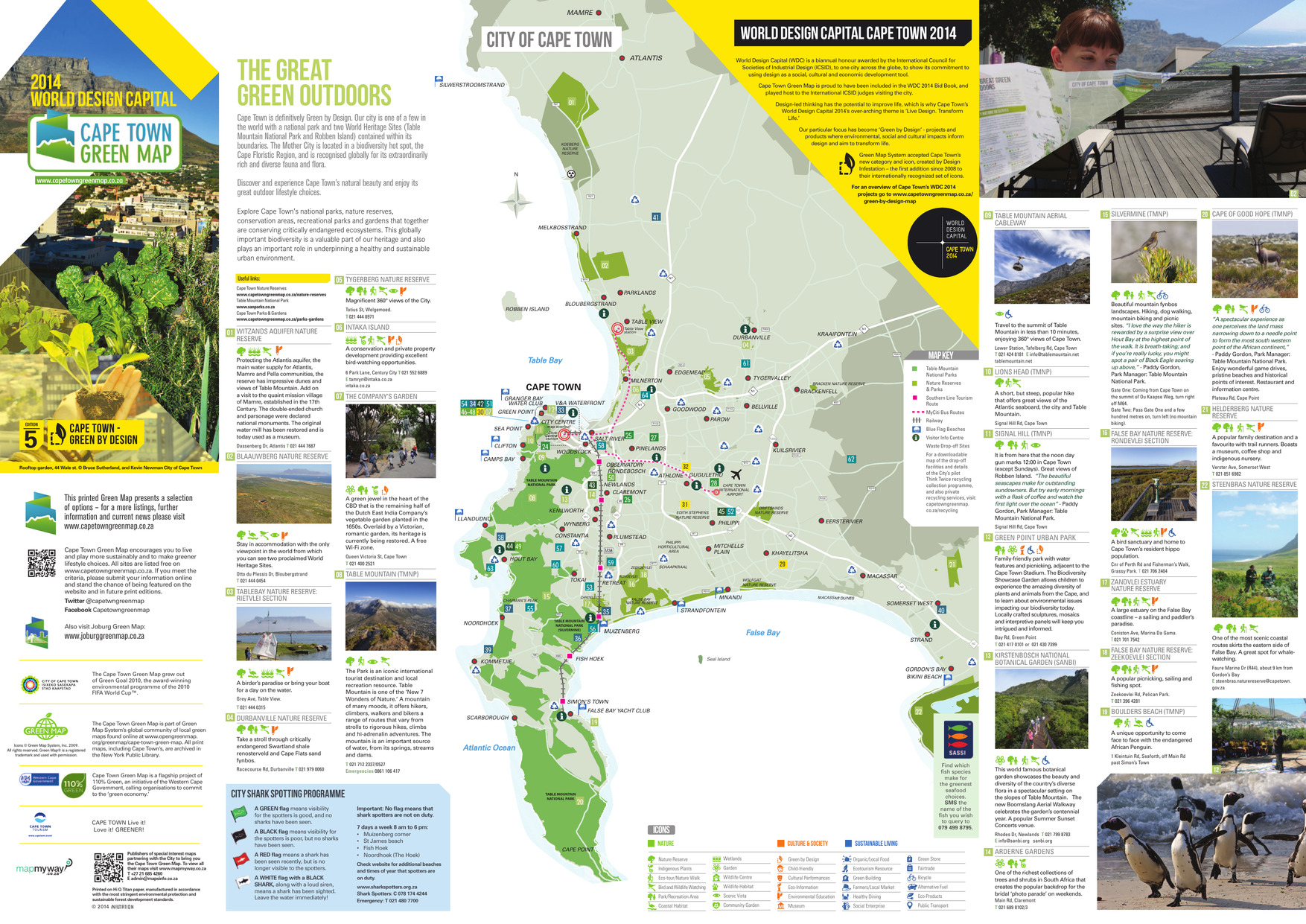
- The great green outdoors
- Subject:
- Recreation areas, Outdoor recreation, Beaches, Parks, and Nature conservation
- Creator:
- City of Cape Town (South Africa)
- Publisher:
- A&C Maps
- Language:
- eng
- Date Created:
- 2014
- Rights Statement:
- In Copyright - Educational Use Permitted
- License:
- This material is made available on this site for research and private study only.
- Resource Type:
- Still Image
- Identifier:
- Green Map System Number: AF1
- Extent:
- 1 map : colour
- Edition:
- 5th edition
- Geographic Coverage:
- South Africa--Cape Town
- Coordinates:
- -33.92584, 18.42322
- Chronological Coverage:
- 2014
- Collection:
- International Green Maps
- Provenance:
- Digital files provided by Green Map System, New York, NY.
- Provider:
- University of Victoria (B.C.). Library
- Genre:
- maps (documents)
- Date Digitized:
- 2018-03-28
- Technical Note:
- Adobe PDF. Received in digital format. Metadata by PD and MT.
- Keyword in Context:
- Transcript available<br/>TOKAI CAPE TOWN INTERNATIONAL AIRPORT KOMMETJIE ATLANTIS MAMRE ZEEKOEIVLEI ZANDVLEI RONDEVLEI Seal Island CHAPMAN’S PEAK FALSE BAY NATURE RESERVE Table Bay CAPE TOWN TABLE MOUNTAIN NATIONAL PARK (SILVERMINE) TABLE MOUNTAIN NATIONAL PARK TABLE MOUNTAIN NA...

- Alternative Title:
- Green World of Prince Alexander, The
- Subject:
- Trees, Wildlife conservation, Recreation areas, Nature conservation, Plants, and Parks
- Creator:
- Roeloffzen, Anton and van Essen, Jessica
- Contributor:
- Lievaart Vormgeving & Communicatie (Firm)
- Publisher:
- Centrum voor Natuur en Milieueducatie 'De Blijde Wei'
- Language:
- nld
- Date Created:
- 2003
- Rights Statement:
- In Copyright - Educational Use Permitted
- License:
- This material is made available on this site for research and private study only.
- Resource Type:
- Still Image
- Identifier:
- Green Map System Number: EU7
- Extent:
- 1 map : colour ; 49 x 69 cm
- Geographic Coverage:
- Netherlands--Rotterdam
- Coordinates:
- 51.9225, 4.47917
- Chronological Coverage:
- 2003
- Collection:
- International Green Maps
- Provenance:
- Digital files provided by Green Map System, New York, NY.
- Provider:
- University of Victoria (B.C.). Library
- Genre:
- maps (documents)
- Date Digitized:
- 2018-03-26
- Technical Note:
- 200 dpi TIFF. Received in digital format. Metadata by PD and MT.
- Keyword in Context:
- Transcript available<br/>I o.p f ~- • Parken, bijzondere bomen en tuinen • Fiets- en wandelroutes Gezien in Prins Alexander Ekster Lepelaar Krooneend Groene specht Putter Torenvalk Groot koolwitje Ringslang ------- \._ \ \ " -~· \ ---------- I I I ------/ --- \ ...

- Alternative Title:
- Groene Kaart Amsterdam
- Subject:
- Sustainable living, Natural areas, Recreation areas, and Community development
- Creator:
- Weijs, Jeroen
- Contributor:
- Innovaders
- Publisher:
- Green Map Amsterdam
- Language:
- nld and eng
- Date Created:
- 2006
- Rights Statement:
- In Copyright - Educational Use Permitted
- License:
- This material is made available on this site for research and private study only.
- Resource Type:
- Still Image
- Identifier:
- Green Map System Number: EU56
- Extent:
- 1 map : colour
- Geographic Coverage:
- Netherlands--Amsterdam
- Coordinates:
- 52.37403, 4.88969
- Chronological Coverage:
- 2006
- Collection:
- International Green Maps
- Provenance:
- Digital files provided by Green Map System, New York, NY.
- Provider:
- University of Victoria (B.C.). Library
- Genre:
- maps (documents)
- Date Digitized:
- 2004-05-06
- Technical Note:
- 300 dpi TIFF. Born digital resource. Metadata by PD and MT.

- Subject:
- Outdoor recreation, Local transit, Recreation areas, and Biodiversity
- Creator:
- Toyota City Green Map, Aichi
- Contributor:
- Toyota Seinen Kaigisho (Junior Chamber International Toyota)
- Publisher:
- Past Mapmakers
- Language:
- jpn
- Date Created:
- 2003
- Rights Statement:
- In Copyright - Educational Use Permitted
- License:
- This material is made available on this site for research and private study only.
- Resource Type:
- Text
- Identifier:
- Green Map System Number: JP30
- Extent:
- 1 map : colour ; 41 x 57 cm
- Geographic Coverage:
- Japan--Toyota-shi
- Coordinates:
- 35.087, 137.15
- Chronological Coverage:
- 2003
- Collection:
- International Green Maps
- Provenance:
- Digital files provided by Green Map System, New York, NY.
- Provider:
- University of Victoria (B.C.). Library
- Genre:
- maps (documents)
- Date Digitized:
- 2004-06-23
- Technical Note:
- 300 dpi TIFF. Born digital resource. Metadata by PD and MT.

- Alternative Title:
- Philadelphus Green Map, Wakulla Green Map, Red Banks Green Map, Maxton Green Map, Pembroke Green Map, Alma Green Map, and Red Springs Green Map
- Subject:
- Recreation areas, Recycling (Waste, etc.), Farmers' markets, Parks, Community centers, Gardens, Cycling, Sewage, Plants, Water treatment plants--Waste disposal, and Environmental education
- Creator:
- Robeson County Green Map Project
- Contributor:
- Robeson County Green Map Project
- Publisher:
- Robeson County Green Map Project
- Language:
- eng
- Rights Statement:
- In Copyright - Educational Use Permitted
- License:
- This material is made available on this site for research and private study only.
- Resource Type:
- Text
- Identifier:
- Green Map System Number: US85
- Extent:
- 1 map : colour ; 35 x 21 cm
- Geographic Coverage:
- North Carolina--Pembroke, United States, North Carolina--Alma, North Carolina--Red Banks, North Carolina--Robeson County, North Carolina--Wakulla, North Carolina--Maxton, North Carolina--Philadelphus, and North Carolina--Red Springs
- Coordinates:
- 34.70294, -79.25087, 34.75905, -79.17142, 34.73516, -79.34893, 34.72377, -79.31254, 34.64009, -79.10353, 34.68016, -79.19504, 34.79266, -79.25504, 39.76, -98.5, and 34.81516, -79.18309
- Collection:
- International Green Maps
- Provenance:
- Digital files provided by Green Map System, New York, NY.
- Provider:
- University of Victoria (B.C.). Library
- Genre:
- maps (documents)
- Date Digitized:
- 2004-05-06
- Technical Note:
- 200 dpi TIFF. Received in digital format. Metadata by PD and MT.

- Subject:
- Plants, Parks, Outdoor recreation, Trees, Community centers, Recycling (Waste, etc.), Museums, and Recreation areas
- Creator:
- Nishinomiya-Kofu Senior High School
- Language:
- jpn
- Date Created:
- 2002
- Rights Statement:
- In Copyright - Educational Use Permitted
- License:
- This material is made available on this site for research and private study only.
- Resource Type:
- Still Image
- Identifier:
- Green Map System Number: JP24
- Extent:
- 1 map : colour ; 41 x 29 cm
- Geographic Coverage:
- Japan--Nishinomiya-shi
- Coordinates:
- 34.78194, 135.30247
- Chronological Coverage:
- 2002
- Collection:
- International Green Maps
- Provenance:
- Digital files provided by Green Map System, New York, NY.
- Provider:
- University of Victoria (B.C.). Library
- Genre:
- maps (documents)
- Date Digitized:
- 2007-06-07
- Technical Note:
- Adobe PDF. Received in digital format. Metadata by PD and MT.

- Alternative Title:
- LoMap: explore downtown's environment as guided by youth
- Subject:
- Libraries, Public art, Farmers' markets, Community centers, Museums, Recycling (Waste, etc.), Air--Pollution, Local transit, Recreation centers, Thrift shops, Voluntarism, Culture, Animals, Parks, Recreation areas, Renewable energy sources, Community gardens, and Plants
- Creator:
- Green Map System (Firm)
- Contributor:
- Kline, Diana Signe, Ferguson, Beth, and Brawer, Wendy E.
- Publisher:
- New York Recycled Paper Inc.
- Language:
- eng
- Date Created:
- 2000
- Rights Statement:
- In Copyright - Educational Use Permitted
- License:
- This material is made available on this site for research and private study only.
- Resource Type:
- Still Image
- Identifier:
- Green Map System Number: US3
- Extent:
- 1 map : colour ; 94 x 30 cm
- Geographic Coverage:
- New York (State)--New York--Manhattan, New York (State), and United States
- Coordinates:
- 40.78343, -73.96625, 40.71427, -74.00597, and 39.76, -98.5
- Chronological Coverage:
- 2000
- Collection:
- International Green Maps
- Provenance:
- Digital files provided by Green Map System, New York, NY.
- Provider:
- University of Victoria (B.C.). Library
- Genre:
- maps (documents)
- Date Digitized:
- 2007-06-11
- Technical Note:
- Adobe PDF. Received in digital format. Metadata by PD and MT.

- Subject:
- Wetlands, Parks, Recreation areas, Remote-sensing images, Natural areas, and Outdoor recreation
- Creator:
- Sustainable Calgary
- Contributor:
- Canada Millennium Partnership Program
- Publisher:
- City of Calgary
- Language:
- eng
- Date Created:
- 2000
- Rights Statement:
- In Copyright - Educational Use Permitted
- License:
- This material is made available on this site for research and private study only.
- Resource Type:
- Still Image
- Identifier:
- Green Map System Number: CA16
- Extent:
- 1 map : colour ; 83 x 59 cm
- Geographic Coverage:
- Alberta--Calgary
- Coordinates:
- 51.05011, -114.08529
- Chronological Coverage:
- 2000/2001
- Collection:
- International Green Maps
- Provenance:
- Digital files provided by Green Map System, New York, NY.
- Provider:
- University of Victoria (B.C.). Library
- Genre:
- maps (documents) and satellite imagery
- Date Digitized:
- 2007-05-19
- Technical Note:
- Adobe PDF. Received in digital format. Metadata by PD and MT.

- Alternative Title:
- Kenoh Green Map, Tsubame-Sanjo, Nigata Pref. and Niigata prefecture Kenoh Green Map
- Subject:
- Neighborhoods, Museums, Outdoor recreation, Recreation areas, Plants, Trees, Wildlife conservation, and Parks
- Creator:
- Yokoki, Hiroyuki
- Publisher:
- Tsubame-Sanjo Junior Chamber of Commerce
- Language:
- jpn
- Date Created:
- 2003
- Rights Statement:
- In Copyright - Educational Use Permitted
- License:
- This material is made available on this site for research and private study only.
- Resource Type:
- Text
- Identifier:
- Green Map System Number: JP32
- Extent:
- 1 map : colour ; 58 x 41 cm
- Geographic Coverage:
- Japan--Tagami-machi, Japan--Teradomari-machi, Japan--Sanjō-shi, Japan--Niigata-ken, and Japan--Tsubame-shi
- Coordinates:
- 37.61667, 138.95, 37.69828, 139.06947, 37.52343, 138.91748, 37.6645, 138.92518, and 37.58333, 138.73333
- Chronological Coverage:
- 2003
- Collection:
- International Green Maps
- Provenance:
- Digital files provided by Green Map System, New York, NY.
- Provider:
- University of Victoria (B.C.). Library
- Genre:
- maps (documents)
- Date Digitized:
- 2004-06-23
- Technical Note:
- 300 dpi TIFF. Born digital resource. Metadata by PD and MT.

- Alternative Title:
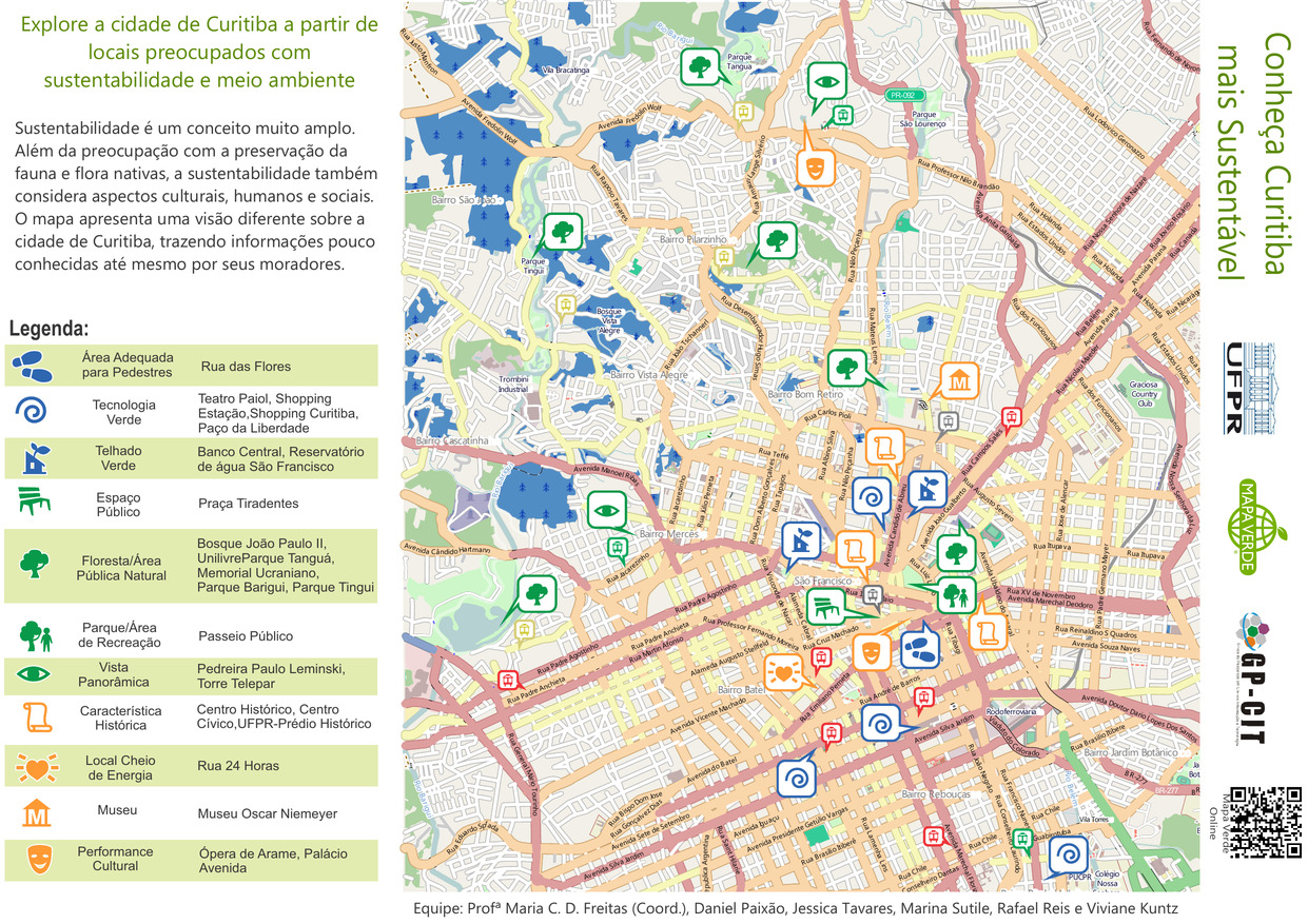
- Conheça Curitiba mais Sustentável
- Subject:
- Recreation areas, Parks, Museums, Sustainable living, Sustainable buildings, and Neighborhoods
- Contributor:
- Paixão, Daniel, Reis, Rafael, Kuntz, Viviane, Freitas, Maria C. D., Tavares, Jessica, and Sutile, Marina
- Publisher:
- Green Map System
- Language:
- por
- Date Created:
- 2014
- Rights Statement:
- In Copyright - Educational Use Permitted
- License:
- This material is made available on this site for research and private study only.
- Resource Type:
- Still Image
- Extent:
- 1 map : colour
- Geographic Coverage:
- Brazil--Curitiba
- Coordinates:
- -25.42778, -49.27306
- Chronological Coverage:
- 2014
- Collection:
- International Green Maps
- Provenance:
- Digital files provided by Green Map System, New York, NY.
- Provider:
- University of Victoria (B.C.). Library
- Genre:
- maps (documents)
- Date Digitized:
- 2014-07-16
- Technical Note:
- Adobe PDF. Received in digital format. Metadata by PD and MT.
- Keyword in Context:
- Transcript available<br/>Untitled-1 Bairro Rebouças Bairro Mercês Bairro Pilarzinho Bairro Bom Retiro São Francisco Centro Bairro Jardim Botânico Bairro Prado Velho Bairro Batel Bairro Vista Alegre Bairro Cascatinha Bairro São João Vila Torres BR-277 PR-092 BR-116 A v e n ida N...