Search
Search Constraints
Start Over Filtering by: Subject Sustainable living ✖ Remove constraint Subject: Sustainable living
« Previous |
11 - 19 of 19
|
Next »
Number of results to display per page
Search Results
-

- Alternative Title
- Gorge Tillicum Community Tables Map
- Subject
- Environmental conditions, Environmental policy, City planning, Neighborhoods, Green movement, and Sustainable living
- Creator
- Josephson, Ken
- Contributor
- Common Ground Community Mapping Project and University of Victoria (B.C.). Department of Geography
- Publisher
- Green Map System (Firm)
- Language
- eng
- Date created
- 2012
- Rights Statement
- In Copyright - Educational Use Permitted
- Resource Type
- Still Image
- Extent
- 1 map on 2 sheets : colour, vinyl ; on sheet 152 x 94 cm
- Geographic Coverage
- British Columbia--Victoria--Gorge Tillicum and British Columbia--Victoria
- Coordinates
- 48.4359, -123.35155
- Chronological Coverage
- 2011/2012
- Collection
- Community Mapping Project
- Provenance
- Digital files provided by University of Victoria Department of Geography.
- Provider
- University of Victoria (B.C.). Library
- Genre
- road maps and maps (documents)
- Date Digitized
- 2013-07-11
- Technical Note
- 283 dpi JPG. Born digital resource. Metadata by CDW and MT.
-

- Alternative Title
- North Park Engaging Neighbours Report & Map
- Subject
- Green movement, Neighborhoods, Sustainable living, Environmental conditions, City planning, and Environmental policy
- Creator
- Josephson, Ken
- Contributor
- University of Victoria (B.C.). Department of Geography, Smith, Barbara, Binion, Eric, Lydon, Maeve, Potts, Karen, Willott, Lisa, Todesco, Tara, and Common Ground Community Mapping Project
- Publisher
- Green Map System (Firm)
- Language
- eng
- Date created
- 2012
- Rights Statement
- In Copyright - Educational Use Permitted
- Resource Type
- Still Image
- Extent
- 1 map on 2 sheets : colour, vinyl ; on sheet 152 x 94 cm
- Geographic Coverage
- British Columbia--Victoria--North Park and British Columbia--Victoria
- Coordinates
- 48.4359, -123.35155 and 48.430999590615414, -123.35688236469441
- Chronological Coverage
- 2011/2012
- Collection
- Community Mapping Project
- Provenance
- Digital files provided by University of Victoria Department of Geography.
- Provider
- University of Victoria (B.C.). Library
- Genre
- maps (documents) and road maps
- Date Digitized
- 2013-07-11
- Technical Note
- 283 dpi JPG. Born digital resource. Metadata by CDW and MT.
-

- Alternative Title
- Oaklands Engaging Neighbours Report & Map
- Subject
- Neighborhoods, Green movement, Environmental policy, City planning, Environmental conditions, and Sustainable living
- Creator
- Josephson, Ken
- Contributor
- University of Victoria (B.C.). Department of Geography and Common Ground Community Mapping Project
- Publisher
- Green Map System (Firm)
- Language
- eng
- Date created
- 2012
- Rights Statement
- In Copyright - Educational Use Permitted
- Resource Type
- Still Image
- Extent
- 1 map on 2 sheets : colour, vinyl ; on sheet 91 x 61 cm
- Geographic Coverage
- British Columbia--Victoria and British Columbia--Victoria--Oaklands
- Coordinates
- 48.4423257027987, -123.34189040131436 and 48.4359, -123.35155
- Chronological Coverage
- 2011/2012
- Collection
- Community Mapping Project
- Provenance
- Digital files provided by University of Victoria Department of Geography.
- Provider
- University of Victoria (B.C.). Library
- Genre
- road maps and maps (documents)
- Date Digitized
- 2013-07-11
- Technical Note
- 283 dpi JPG. Born digital resource. Metadata by CDW and MT.
-

- Alternative Title
- Brentwood Bay
- Subject
- Sustainable living and Neighborhoods
- Creator
- Josephson, Ken
- Contributor
- University of Victoria (B.C.). Department of Geography, Common Ground Community Mapping Project, and Lydon, Maeve
- Publisher
- Green Map System (Firm)
- Language
- eng
- Date created
- 2013?
- Rights Statement
- In Copyright - Educational Use Permitted
- Resource Type
- Text
- Extent
- 1 map on 2 sheets : colour, vinyl ; on sheet 91 x 61 cm
- Geographic Coverage
- British Columbia and British Columbia--Central Saanich--Brentwood Bay
- Coordinates
- 48.58294, -123.45262
- Chronological Coverage
- 2012/2013
- Additional Physical Characteristics
- Scale: ca. 1:1320
- Collection
- Community Mapping Project
- Provenance
- Digital files provided by University of Victoria Department of Geography.
- Provider
- University of Victoria (B.C.). Library
- Genre
- road maps and maps (documents)
- Date Digitized
- 2013-07-10
- Technical Note
- 288 dpi JPG. Born digital resource. Metadata by CDW and MT.
-

- Alternative Title
- Colwood Engaging Neighbours Report & Map
- Subject
- Neighborhoods, Environmental conditions, City planning, Environmental policy, Sustainable living, and Green movement
- Creator
- Josephson, Ken
- Contributor
- Nahser-Ringer, Erich, Lydon, Maeve, Cross, Geoff, Todesco, Tara, Engen, Amanda, Common Ground Community Mapping Project, and University of Victoria (B.C.). Department of Geography
- Publisher
- Green Map System (Firm)
- Language
- eng
- Date created
- 2013?
- Rights Statement
- In Copyright - Educational Use Permitted
- Resource Type
- Still Image
- Identifier
- Call Number: G3514 V5G3 2013 G743
- Extent
- 1 map on 2 sheets : colour, vinyl ; on sheet 91 x 61 cm
- Geographic Coverage
- British Columbia--Victoria and British Columbia--Victoria--Colwood
- Coordinates
- 48.43293, -123.48591
- Chronological Coverage
- 2012/2013
- Additional Physical Characteristics
- Scale: ca. 1:8300
- Collection
- Community Mapping Project
- Provenance
- Digital files provided by University of Victoria Department of Geography.
- Provider
- University of Victoria (B.C.). Library
- Genre
- maps (documents) and road maps
- Date Digitized
- 2010-07-10
- Technical Note
- 284 dpi JPG. Born digital resource. Metadata by CDW and MT.
-

- Alternative Title
- Green Map of Cerrado Gardens
- Subject
- Neighborhoods, Sustainable living, and Natural monuments
- Publisher
- Instituto Brookfield
- Language
- por
- Date created
- 2013
- Rights Statement
- In Copyright - Educational Use Permitted
- Resource Type
- Still Image
- Extent
- 1 map : colour
- Geographic Coverage
- Brazil--Goiânia
- Coordinates
- -16.67861, -49.25389
- Chronological Coverage
- 2012/2013
- Collection
- International Green Maps
- Provenance
- Digital files provided by Green Map System, New York, NY.
- Provider
- University of Victoria (B.C.). Library
- Genre
- maps (documents)
- Date Digitized
- 2014-01-08
- Technical Note
- Adobe PDF. Received in digital format. Metadata by PD and MT.
- Keyword in Context
- Mapa Verde do bairro Jardins do Cerrado Goiânia – Goiás – Brasil O institutO brOOkfield O Instituto Brookfield é uma organização sem fins lucrativos dedicada ao desenvolvimento sustentável das regiões de atuação da sua principal mantenedora, a Brookfield Incorporaçõ...
-

- Alternative Title
- Marigold
- Subject
- Neighborhoods, Environmental policy, City planning, Sustainable living, Green movement, and Environmental conditions
- Creator
- Josephson, Ken
- Contributor
- Lydon, Maeve, University of Victoria (B.C.). Department of Geography, Common Ground Mapping Project, Slaunwhite, Amanda, Fraser, Michael, and Nahser-Ringer, Erich
- Publisher
- Green Map System (Firm)
- Language
- eng
- Date created
- 2014
- Rights Statement
- In Copyright - Educational Use Permitted
- Resource Type
- Still Image
- Extent
- 1 map on 2 sheets : colour
- Geographic Coverage
- British Columbia--Victoria and British Columbia--Saanich--Marigold
- Coordinates
- 48.46667, -123.4 and 48.4359, -123.35155
- Chronological Coverage
- 2014
- Collection
- Community Mapping Project
- Provenance
- Digital files provided by University of Victoria Department of Geography.
- Provider
- University of Victoria (B.C.). Library
- Genre
- road maps and maps (documents)
- Date Digitized
- 2014-07-07
- Technical Note
- 600 dpi JPG. Born digital resource. Metadata by CDW and MT.
-
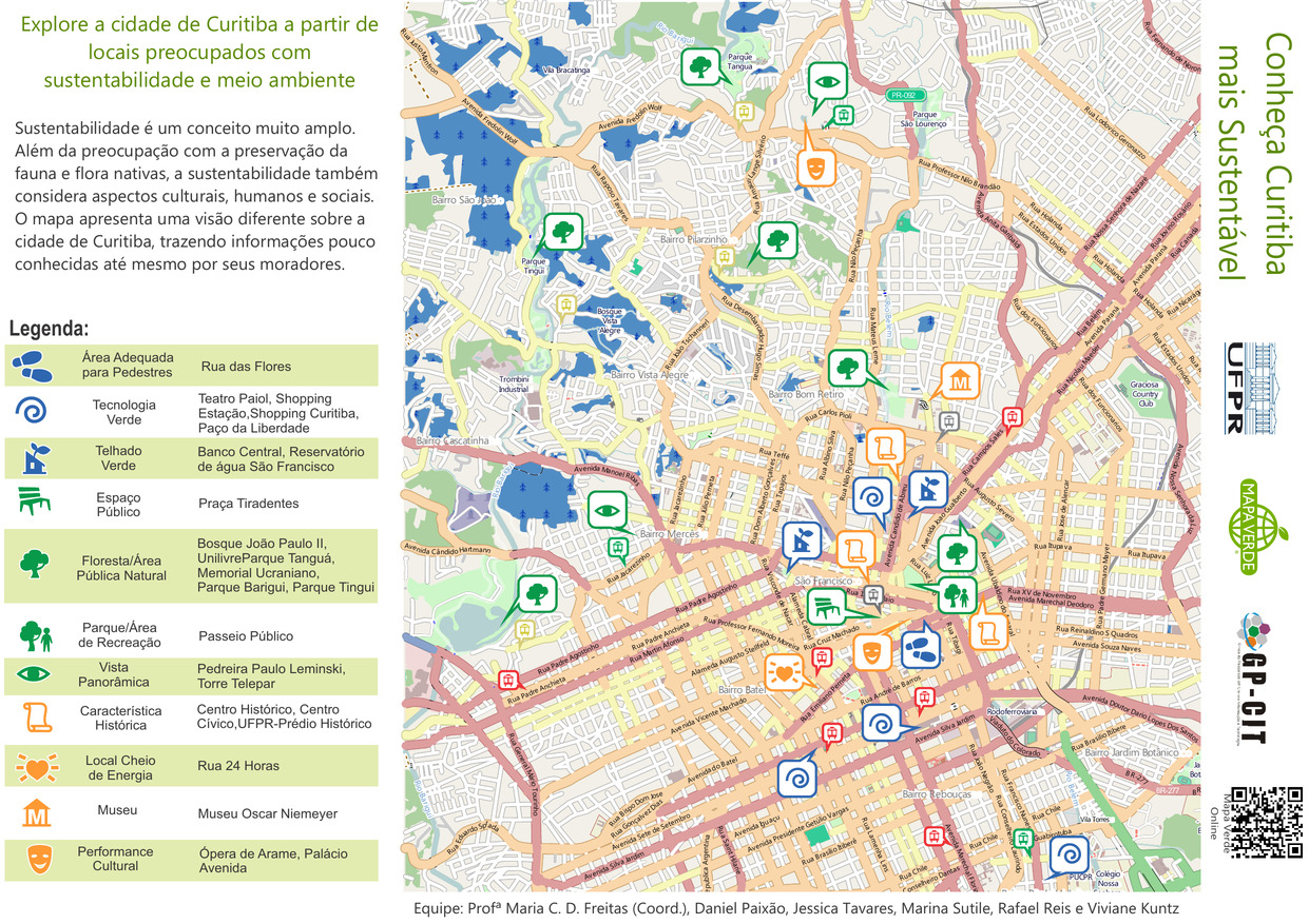
- Alternative Title
- Conheça Curitiba mais Sustentável
- Subject
- Recreation areas, Parks, Museums, Sustainable living, Sustainable buildings, and Neighborhoods
- Contributor
- Paixão, Daniel, Reis, Rafael, Kuntz, Viviane, Freitas, Maria C. D., Tavares, Jessica, and Sutile, Marina
- Publisher
- Green Map System
- Language
- por
- Date created
- 2014
- Rights Statement
- In Copyright - Educational Use Permitted
- Resource Type
- Still Image
- Extent
- 1 map : colour
- Geographic Coverage
- Brazil--Curitiba
- Coordinates
- -25.42778, -49.27306
- Chronological Coverage
- 2014
- Collection
- International Green Maps
- Provenance
- Digital files provided by Green Map System, New York, NY.
- Provider
- University of Victoria (B.C.). Library
- Genre
- maps (documents)
- Date Digitized
- 2014-07-16
- Technical Note
- Adobe PDF. Received in digital format. Metadata by PD and MT.
- Keyword in Context
- Untitled-1 Bairro Rebouças Bairro Mercês Bairro Pilarzinho Bairro Bom Retiro São Francisco Centro Bairro Jardim Botânico Bairro Prado Velho Bairro Batel Bairro Vista Alegre Bairro Cascatinha Bairro São João Vila Torres BR-277 PR-092 BR-116 A v e n ida N...
-

- Alternative Title
- Fernwood Community Green Map
- Subject
- City planning, Sustainable living, Community development, and Neighborhoods
- Creator
- Fernwood Neighbourhood Resource Group
- Contributor
- Doherty, Dan
- Publisher
- Green Map System (Firm)
- Language
- eng
- Date created
- 2015
- Rights Statement
- In Copyright - Educational Use Permitted
- Resource Type
- Still Image
- Identifier
- Call Number: Wall map 329
- Extent
- 2 maps on 2 sheets : colour, vinyl ; on sheet 152 x 188 cm
- Geographic Coverage
- British Columbia--Victoria, British Columbia--Victoria--Fernwood, and British Columbia--Victoria Region
- Coordinates
- 48.4359, -123.35155 and 48.91354, -123.53596
- Chronological Coverage
- 1843/1914
- Additional Physical Characteristics
- Scale: 1:3636
- Collection
- Community Mapping Project
- Provenance
- High resolution maps made available through the UVic Community Mapping Collaboratory in April 2015.Web-ready image files provided by the UVic Community Mapping Collaboratory.
- Provider
- University of Victoria (B.C.). Library
- Genre
- maps (documents), cadastral maps, and historical maps
- Date Digitized
- 2015-03-26
- Technical Note
- 300 dpi JPG. Born digital resource. Metadata by CDM and MT.
- « Previous
- 1
- 2