Search
Search Constraints
Start Over Filtering by: Subject Sustainable living ✖ Remove constraint Subject: Sustainable living
« Previous |
1 - 10 of 19
|
Next »
Number of results to display per page
Search Results
-
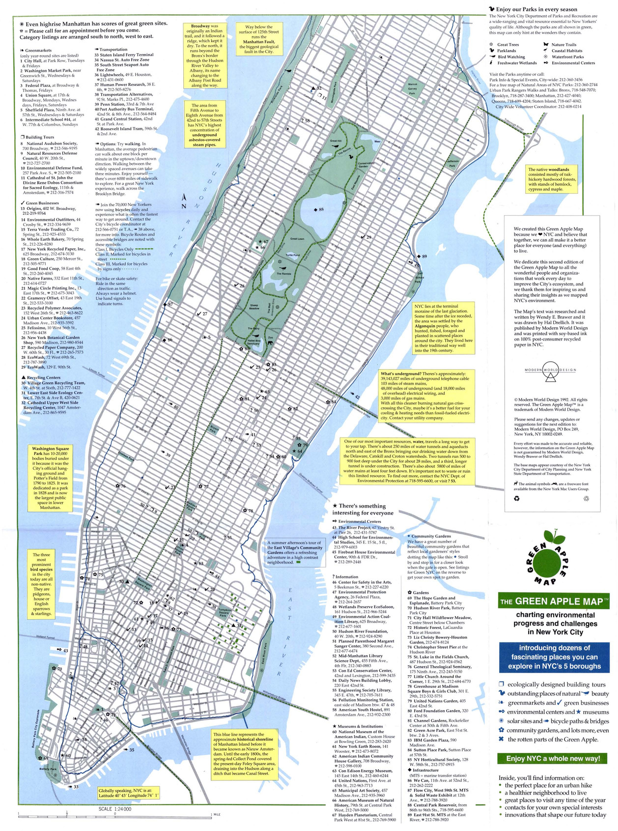
- Alternative Title
- Green Map NYC
- Subject
- Sustainable buildings, Zoos, Refuse and refuse disposal, Local transit, Recycling (Waste, etc.), Farmers' markets, Sustainable living, Community gardens, and Museums
- Creator
- Drelich, Hal
- Contributor
- Brawer, Wendy E.
- Publisher
- Modern World Design
- Language
- eng
- Date created
- 1994
- Rights Statement
- In Copyright - Educational Use Permitted
- Resource Type
- Still Image
- Identifier
- Green Map System Number: US1
- Extent
- 1 map : colour ; 43 x 27 cm
- Edition
- 2nd edition
- Geographic Coverage
- New York (State)--New York and United States
- Coordinates
- 40.71427, -74.00597 and 39.76, -98.5
- Chronological Coverage
- 1992
- Collection
- International Green Maps
- Provenance
- Digital files provided by Green Map System, New York, NY.
- Provider
- University of Victoria (B.C.). Library
- Genre
- maps (documents)
- Date Digitized
- 2007-06-11
- Technical Note
- Adobe PDF. Received in digital format. Metadata by PD and MT.
-

- Alternative Title
- Discover Malmö the green way, Upptäck Malmös gröna sidor, and Malmo Green Map
- Subject
- Sustainable living, Recycling (Waste, etc.)--Citizen participation, Organic farming, Sustainable urban development, Recycling (Waste, etc.), and Local transit
- Creator
- Richter, Bengt-Arne and Fossum, Tor
- Contributor
- Dolocek, John, Gothrick, Hans-Lennart, and Kunskap Malmo
- Publisher
- Malmö Green Map
- Language
- eng and swe
- Date created
- 1999
- Rights Statement
- In Copyright - Educational Use Permitted
- Resource Type
- Still Image
- Identifier
- Green Map System Number: EU17
- Extent
- 1 map : colour ; 59 x 41 cm
- Edition
- 2nd edition
- Geographic Coverage
- Sweden--Malmö
- Coordinates
- 57.81667, 16.7
- Chronological Coverage
- 1999
- Collection
- International Green Maps
- Provenance
- Digital files provided by Green Map System, New York, NY.
- Provider
- University of Victoria (B.C.). Library
- Genre
- maps (documents)
- Date Digitized
- 2007-06-11
- Technical Note
- Adobe PDF. Received in digital format. Metadata by PD and MT.
-

- Alternative Title
- Goteborg and Region Vastra Gotaland Green Map
- Subject
- Wetlands, Local transit, Renewable energy sources, Sustainable living, Community development, Biodiversity, Natural areas, Sustainable urban development, and Sustainable buildings
- Creator
- Göteborg (Sweden). Stadsbyggnadskontoret
- Contributor
- Vastra Gotalandsregionen Miljonamnden
- Publisher
- Ekocentrum
- Language
- eng
- Date created
- 2000
- Rights Statement
- In Copyright - Educational Use Permitted
- Resource Type
- Text
- Identifier
- Green Map System Number: EU12
- Extent
- 1 map : colour ; 41 x 29 cm
- Geographic Coverage
- Sweden--Göteborg
- Coordinates
- 57.70716, 11.96679
- Chronological Coverage
- 2000
- Collection
- International Green Maps
- Provenance
- Digital files provided by Green Map System, New York, NY.
- Provider
- University of Victoria (B.C.). Library
- Genre
- maps (documents)
- Date Digitized
- 2004-05-06
- Technical Note
- 200 dpi TIFF. Born digital resource. Metadata by PD and MT.
-
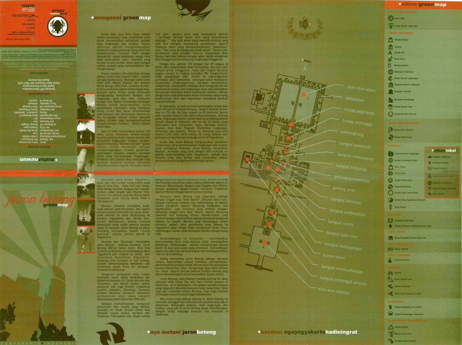
- Alternative Title
- Jeron Beteng Yogyakarta green map
- Subject
- Sustainable living, Neighborhoods, and Natural areas
- Creator
- Green Mapper Jogja
- Contributor
- Universitas Gadjah Mada and Center for Heritage Conservation Department of Architecture, Faculty of Engineering
- Publisher
- Press, Culture & Education Royal Netherlands Embassy
- Language
- ind
- Date created
- 2002
- Rights Statement
- In Copyright - Educational Use Permitted
- Resource Type
- Text
- Identifier
- Green Map System Number: AS21
- Extent
- 1 map : colour ; 62 x 44 cm
- Geographic Coverage
- Indonesia--Yogyakarta
- Coordinates
- -7.80139, 110.36472
- Chronological Coverage
- 2002
- Collection
- International Green Maps
- Provenance
- Digital files provided by Green Map System, New York, NY.
- Provider
- University of Victoria (B.C.). Library
- Genre
- maps (documents)
- Date Digitized
- 2007-06-19
- Technical Note
- Adobe PDF. Received in digital format. Metadata by PD and MT.
-

- Alternative Title
- Peta Hijau Kemang
- Subject
- Natural areas, Neighborhoods, and Sustainable living
- Creator
- Green Map Indonesia
- Publisher
- Green Map Indonesia
- Language
- ind
- Date created
- 2002
- Rights Statement
- In Copyright - Educational Use Permitted
- Resource Type
- Text
- Identifier
- Green Map System Number: AS33
- Extent
- 1 map : colour
- Geographic Coverage
- Indonesia--Jakarta
- Coordinates
- -6.21462, 106.84513
- Chronological Coverage
- 2002
- Collection
- International Green Maps
- Provenance
- Digital files provided by Green Map System, New York, NY.
- Provider
- University of Victoria (B.C.). Library
- Genre
- maps (documents)
- Date Digitized
- 2007-06-19
- Technical Note
- Adobe PDF. Received in digital format. Metadata by PD and MT.
-

- Alternative Title
- Mapa Verde Barrio Chino cuidad de Nueva York
- Subject
- Neighborhoods, Renewable energy sources, Sustainable urban development, Public art, Farmers' markets, Museums, Sustainable living, Community centers, Culture, and Open spaces
- Creator
- Rubio, Carlos A. Martinez
- Publisher
- Green Map System
- Language
- spa and eng
- Date created
- 2006
- Rights Statement
- In Copyright - Educational Use Permitted
- Resource Type
- Still Image
- Extent
- 1 map : colour
- Geographic Coverage
- United States and New York (State)--New York
- Coordinates
- 40.71427, -74.00597 and 39.76, -98.5
- Chronological Coverage
- 2006
- Collection
- International Green Maps
- Provenance
- Digital files provided by Green Map System, New York, NY.
- Provider
- University of Victoria (B.C.). Library
- Genre
- maps (documents)
- Date Digitized
- 2012-01-10
- Technical Note
- Adobe PDF. Received in digital format. Metadata by PD and MT.
- Keyword in Context
- MapaVerdeChinatown.psd
-

- Alternative Title
- Groene Kaart Amsterdam
- Subject
- Sustainable living, Natural areas, Recreation areas, and Community development
- Creator
- Weijs, Jeroen
- Contributor
- Innovaders
- Publisher
- Green Map Amsterdam
- Language
- nld and eng
- Date created
- 2006
- Rights Statement
- In Copyright - Educational Use Permitted
- Resource Type
- Still Image
- Identifier
- Green Map System Number: EU56
- Extent
- 1 map : colour
- Geographic Coverage
- Netherlands--Amsterdam
- Coordinates
- 52.37403, 4.88969
- Chronological Coverage
- 2006
- Collection
- International Green Maps
- Provenance
- Digital files provided by Green Map System, New York, NY.
- Provider
- University of Victoria (B.C.). Library
- Genre
- maps (documents)
- Date Digitized
- 2004-05-06
- Technical Note
- 300 dpi TIFF. Born digital resource. Metadata by PD and MT.
-

- Alternative Title
- Highlands District Community Green Map
- Subject
- Environmental policy, Environmental conditions, Nature conservation--Maps, Rural development, and Sustainable living
- Creator
- Highland District Community Association
- Contributor
- Elliot, John and Limbrick, Elaine
- Publisher
- Green Map System (Firm)
- Language
- eng
- Date created
- 2009
- Rights Statement
- In Copyright - Educational Use Permitted
- Resource Type
- Still Image
- Identifier
- Call Number: Wall map 322 and Call Number: G3514 V5:3H5 2008 H5
- Extent
- 1 map on 2 sheets : colour ; 86 x 61 cm
- Geographic Coverage
- British Columbia--Victoria--Highlands and British Columbia--Victoria
- Coordinates
- 48.51633, -123.50261 and 48.4359, -123.35155
- Chronological Coverage
- 2007/2008
- Additional Physical Characteristics
- Scale: 1:15385
- Collection
- Community Mapping Project
- Provenance
- Web-ready image files provided by the UVic Community Mapping Collaboratory.High resolution maps made available through the UVic Community Mapping Collaboratory in April 2015.
- Provider
- University of Victoria (B.C.). Library
- Genre
- maps (documents) and cadastral maps
- Date Digitized
- 2009-05-20
- Technical Note
- 300 dpi JPG. Born digital resource. Metadata by CDM and MT.
-

- Alternative Title
- Shelbourne Corridor Action Plan: map and vision survey results
- Subject
- Neighborhoods, City planning, and Sustainable living
- Creator
- Josephson, Ken
- Contributor
- Lydon, Maeve, Common Ground Community Mapping Project, Fingler, Theresa, and University of Victoria (B.C.). Department of Geography
- Publisher
- Green Map System (Firm)
- Language
- eng
- Date created
- 2010
- Rights Statement
- In Copyright - Educational Use Permitted
- Resource Type
- Still Image
- Extent
- 1 map on 2 sheets : colour
- Geographic Coverage
- British Columbia--Victoria and British Columbia--Saanich
- Coordinates
- 48.4359, -123.35155 and 48.54964, -123.36931
- Chronological Coverage
- 2010-01/2010-05
- Additional Physical Characteristics
- Scale: ca. 1:2800
- Collection
- Community Mapping Project
- Provenance
- Digital files provided by University of Victoria Department of Geography.
- Provider
- University of Victoria (B.C.). Library
- Genre
- maps (documents)
- Date Digitized
- 2016-02-15
- Technical Note
- 400 dpi JPG. Born digital resource. Metadata by CDW and MT.
-

- Subject
- Sustainable living, Neighborhoods, and City planning
- Creator
- Josephson, Ken
- Contributor
- University of Victoria (B.C.). Department of Geography, Common Ground Community Mapping Project, Burnett, Charles, Maass, Amy, Jaswall, Harpreet, and Lydon, Maeve
- Publisher
- Green Map System (Firm)
- Language
- eng
- Date created
- 2010
- Rights Statement
- In Copyright - Educational Use Permitted
- Resource Type
- Still Image
- Extent
- 1 map on 2 sheets : colour
- Geographic Coverage
- British Columbia--Victoria and British Columbia--Victoria--South Jubilee
- Coordinates
- 48.428471548089234, -123.33069155714776 and 48.4359, -123.35155
- Chronological Coverage
- 2010
- Collection
- Community Mapping Project
- Provenance
- Digital files provided by University of Victoria Department of Geography.
- Provider
- University of Victoria (B.C.). Library
- Genre
- road maps and maps (documents)
- Date Digitized
- 2016-02-15
- Technical Note
- 400 dpi JPG. Born digital resource. Metadata by CDW and MT.