Search
Search Results
- Subject:
- Cadastral maps, Cities and towns--Maps, and City planning--Maps
- Creator:
- Tiedemann, Herman Otto
- Language:
- English
- Date Created:
- 1858
- Rights Statement:
- No Copyright - Non-Commercial Use Only
- Resource Type:
- Still Image
- Identifier:
- LSV Number: 14T1
- Extent:
- 1 sheet ; 85 x 110 cm
- Geographic Coverage:
- British Columbia--Esquimalt and British Columbia--Victoria
- Coordinates:
- 48.43569, -123.41174 and 48.4359, -123.35155
- Additional Physical Characteristics:
- Scale: 4 chains to ? inch
- Physical Repository:
- Land Title and Survey Authority of British Columbia
- Collection:
- Land Title and Survey Authority of British Columbia: Early British Columbia Maps
- Provenance:
- Surveyor General of BC, Legal Surveys Vault
- Provider:
- University of Victoria (B.C.). Library
- Genre:
- maps (documents), historical maps, and relief maps
- Date Digitized:
- 2012-02-15
- Technical Note:
- Cataloguing metadata: Provided by the LTSA and adapted by the University of Victoria Libraries to their requirements.

- Alternative Title:
- No. 1 Victoria Town and Plan of Victoria City 1858
- Subject:
- Cities and towns--Maps and City planning--Maps
- Creator:
- Tiedemann, Herman Otto
- Language:
- English
- Date Created:
- 1858
- Rights Statement:
- No Copyright - Non-Commercial Use Only
- Resource Type:
- Still Image
- Identifier:
- LSV Number: 1 Tr LT ECVI
- Extent:
- 1 map and 4 leaves on 1 sheet
- Geographic Coverage:
- British Columbia--Esquimalt and British Columbia--Victoria
- Coordinates:
- 48.43569, -123.41174 and 48.4359, -123.35155
- Additional Physical Characteristics:
- Scale: 4 chain to 1 inch
- Physical Repository:
- Land Title and Survey Authority of British Columbia
- Collection:
- Land Title and Survey Authority of British Columbia: Early British Columbia Maps
- Provenance:
- Surveyor General of BC, Legal Surveys Vault
- Provider:
- University of Victoria (B.C.). Library
- Genre:
- cadastral maps, maps (documents), and relief maps
- Date Digitized:
- 2015-02-23
- Technical Note:
- Cataloguing metadata: Provided by the LTSA and adapted by the University of Victoria Libraries to their requirements.
- Alternative Title:
- Official Plan of City of Esquimalt (unfinished)
- Subject:
- City planning--Maps and Cities and towns--Maps
- Language:
- English
- Date Created:
- 1858
- Rights Statement:
- No Copyright - Non-Commercial Use Only
- Resource Type:
- Still Image
- Identifier:
- LSV Number: 27T1TS and Historical Map Society of B.C. Map Number: 1323
- Extent:
- 1 sheet ; 65 x 80 cm
- Geographic Coverage:
- British Columbia--Esquimalt
- Coordinates:
- 48.43569, -123.41174
- Physical Repository:
- Land Title and Survey Authority of British Columbia
- Collection:
- Land Title and Survey Authority of British Columbia: Early British Columbia Maps
- Provenance:
- Surveyor General of BC, Legal Surveys Vault
- Provider:
- University of Victoria (B.C.). Library
- Genre:
- historical maps, relief maps, and maps (documents)
- Date Digitized:
- 2013-03-07
- Technical Note:
- Cataloguing metadata: Provided by the LTSA and adapted by the University of Victoria Libraries to their requirements.
- Subject:
- Real property
- Creator:
- Dallas, Alexander Grant
- Language:
- English
- Date Created:
- 1858
- Rights Statement:
- No Copyright - Contractual restrictions
- Resource Type:
- Still Image
- Identifier:
- Ruggles Number: 464A and F12/4 fo. 544
- Extent:
- 1 sheet ; 23 x 15 cm
- Geographic Coverage:
- British Columbia--Fraser River Valley and British Columbia--Hope
- Coordinates:
- 49.58299, -121.83587 and 49.38299, -121.44144
- Physical Repository:
- Hudson's Bay Company. Archives
- Collection:
- Early B.C. Maps from the Hudson's Bay Company Archives
- Provider:
- University of Victoria (B.C.). Library
- Genre:
- maps (documents) and historical maps
- Date Digitized:
- 2012-05-02
- Technical Note:
- 600 dpi jpg ; Scanning of transparencies by JF. Watermarking by CDW. Metadata by RM, KM.
- Subject:
- Real property
- Creator:
- Dallas, Alexander Grant
- Language:
- English
- Date Created:
- 1858
- Rights Statement:
- No Copyright - Contractual restrictions
- Resource Type:
- Still Image
- Identifier:
- F12/4 fo. 545 and Ruggles Number: 465A
- Extent:
- 1 sheet ; 12 x 23 cm
- Geographic Coverage:
- British Columbia--Fraser River Valley and British Columbia--Yale
- Coordinates:
- 49.58299, -121.83587 and 49.56202, -121.42974
- Physical Repository:
- Hudson's Bay Company. Archives
- Collection:
- Early B.C. Maps from the Hudson's Bay Company Archives
- Provider:
- University of Victoria (B.C.). Library
- Genre:
- maps (documents) and historical maps
- Date Digitized:
- 2012-05-02
- Transcript:
- House & 3 Lots marked X were lately given by the Governor to a Mr. York.
- Technical Note:
- 600 dpi jpg ; Scanning of transparencies by JF. Watermarking by CDW. Metadata by RM, KM.

- Alternative Title:
- Canal de Haro & Strait of Rosario
- Subject:
- Boundaries
- Creator:
- United States Coast Survey
- Contributor:
- Richards, G. H. (George Henry)
- Language:
- English
- Date Created:
- 1858
- Rights Statement:
- In Copyright - Educational Use Permitted
- Resource Type:
- Still Image
- Identifier:
- Penfold Number: 483
- Extent:
- 1 sheet
- Geographic Coverage:
- Pacific Ocean--Rosario Strait, Pacific Ocean--Strait of Georgia, Pacific Ocean--Haro Strait, and Pacific Ocean--Strait of Juan de Fuca
- Coordinates:
- 48.83149, -122.94463, 48.29674, -124.01225, 49.48262, -124.06723, 48.54886, -123.21891, 48.56121, -122.75962, and 48.54876, -123.21918
- Chronological Coverage:
- 1854/1858
- Physical Repository:
- National Archives (Great Britain)
- Collection:
- Early BC Maps Collection
- Provenance:
- National Archives of the UK
- Provider:
- University of Victoria (B.C.). Library
- Genre:
- maps (documents) and historical maps
- Archival Item Identifier:
- National Archives Number: MPK1-58
- Date Digitized:
- 2010-04-22
- Technical Note:
- Watermarks added to images by KM, JF, and CDW. Metadata by JTP May 3, 2010. and 600 dpi jpg
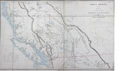
- Alternative Title:
- British Possessions to the West of the Rocky Mountains.
- Subject:
- Indigenous peoples and Agriculture
- Contributor:
- Columbia Detachment, James, H., 1803-1877, and Great Britain. Army. Royal Engineers
- Publisher:
- Great Britain. War Office. Topographical Depot.
- Language:
- English
- Date Created:
- 1858?
- Rights Statement:
- In Copyright - Educational Use Permitted
- Resource Type:
- Still Image
- Identifier:
- National Archives Number: MPG1-136 and Penfold Number: 383
- Extent:
- 1 sheet
- Geographic Coverage:
- British Columbia
- Coordinates:
- 53.99983, -125.0032
- Chronological Coverage:
- 1858
- Additional Physical Characteristics:
- 1:1,520,640
- Physical Repository:
- National Archives (Great Britain)
- Collection:
- Early BC Maps Collection
- Provenance:
- National Archives of the UK
- Provider:
- University of Victoria (B.C.). Library
- Genre:
- maps (documents) and historical maps
- Date Digitized:
- 2010-04-22
- Technical Note:
- 600 dpi jpg. Watermarks added to images by KM, JF, and CDW. Metadata by JTP April 29, 2010.
- Alternative Title:
- British Possessions to the West of the Rocky Mountains.
- Subject:
- Indigenous peoples and Agriculture
- Contributor:
- Columbia Detachment, James, H., 1803-1877, and Great Britain. Army. Royal Engineers
- Publisher:
- Great Britain. War Office. Topographical Depot.
- Language:
- English
- Date Created:
- 1858
- Rights Statement:
- In Copyright - Educational Use Permitted
- Resource Type:
- Still Image
- Identifier:
- Penfold Number: 382
- Extent:
- 1 sheet
- Geographic Coverage:
- British Columbia
- Coordinates:
- 53.99983, -125.0032
- Chronological Coverage:
- 1858
- Additional Physical Characteristics:
- 1:1,457,280
- Physical Repository:
- National Archives (Great Britain)
- Collection:
- Early BC Maps Collection
- Provenance:
- National Archives of the UK
- Provider:
- University of Victoria (B.C.). Library
- Genre:
- maps (documents) and historical maps
- Archival Item Identifier:
- National Archives Number: FO925-1381
- Date Digitized:
- 2010-04-12
- Technical Note:
- 600 dpi jpg and Watermarks added to images by KM, JF, and CDW. Metadata by JTP May 5, 2010.

- Alternative Title:
- British Possessions to the West of the Rocky Mountains.
- Subject:
- Indigenous peoples and Agriculture
- Contributor:
- Columbia Detachment, James, H., 1803-1877, and Great Britain. Army. Royal Engineers
- Publisher:
- Great Britain. War Office. Topographical Depot.
- Language:
- English
- Date Created:
- 1858?
- Rights Statement:
- In Copyright - Educational Use Permitted
- Resource Type:
- Still Image
- Identifier:
- Penfold Number: 381
- Extent:
- 1 sheet
- Geographic Coverage:
- British Columbia
- Coordinates:
- 48N-54N/128W-112W and 53.99983, -125.0032
- Chronological Coverage:
- 1858
- Additional Physical Characteristics:
- 1:1,457,280
- Physical Repository:
- National Archives (Great Britain)
- Collection:
- Early BC Maps Collection
- Provenance:
- National Archives of the UK
- Provider:
- University of Victoria (B.C.). Library
- Genre:
- maps (documents) and historical maps
- Archival Item Identifier:
- National Archives Number: CO700-BRITISH COLUMBIA5
- Date Digitized:
- 2010-04-12
- Technical Note:
- 600 dpi jpg and Watermarks added to images by KM, JF, and CDW. Metadata by JTP April 22, 2010.
- Subject:
- Gold mines and mining and Indigenous peoples
- Creator:
- Douglas, James, 1803-1877
- Language:
- English
- Date Created:
- 1858
- Rights Statement:
- In Copyright - Educational Use Permitted
- Resource Type:
- Still Image
- Identifier:
- National Archives Number: FO925-1808 and Penfold Number: 477
- Extent:
- 1 sheet
- Geographic Coverage:
- British Columbia--Fraser River, British Columbia, and British Columbia--Thompson River
- Coordinates:
- 53.99983, -125.0032, 50.23304, -121.58589, and 52.33313, -123.16961
- Chronological Coverage:
- 1858
- Physical Repository:
- National Archives (Great Britain)
- Collection:
- Early BC Maps Collection
- Provenance:
- National Archives of the UK
- Provider:
- University of Victoria (B.C.). Library
- Genre:
- maps (documents) and historical maps
- Date Digitized:
- 2010-04-12
- Technical Note:
- 600 dpi jpg and Watermarks added to images by KM, JF, and CDW. Metadata by JTP May 5, 2010.