Search
Search Results
- Language:
- English
- Date Created:
- 1859
- Rights Statement:
- No Copyright - Non-Commercial Use Only
- Resource Type:
- Still Image
- Identifier:
- 105467 and LSV Number 24T2ECVI
- Extent:
- 1 sheet ; 60 x 65 cm
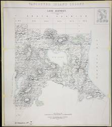
- Geographic Coverage:
- British Columbia--Lake Land District
- Coordinates:
- 48.51634, -123.41931
- Physical Repository:
- Land Title and Survey Authority of British Columbia
- Collection:
- Land Title and Survey Authority of British Columbia: Early British Columbia Maps
- Provenance:
- Surveyor General of BC, Legal Surveys Vault
- Provider:
- University of Victoria (B.C.). Library
- Genre:
- historical maps, relief maps, cadastral maps, and maps (documents)
- Date Digitized:
- 2012-01-25
- Technical Note:
- Cataloguing metadata: Provided by the LTSA and adapted by the University of Victoria Libraries to their requirements.
- Language:
- English
- Date Created:
- 1859
- Rights Statement:
- No Copyright - Non-Commercial Use Only
- Resource Type:
- Still Image
- Identifier:
- 105467 and LSV Number: 24T2ECVI
- Extent:
- 1 sheet ; 60 x 65 cm
- Geographic Coverage:
- British Columbia--Lake Land District
- Coordinates:
- 48.51634, -123.41931
- Physical Repository:
- Land Title and Survey Authority of British Columbia
- Collection:
- Land Title and Survey Authority of British Columbia: Early British Columbia Maps
- Provenance:
- Surveyor General of BC, Legal Surveys Vault
- Provider:
- University of Victoria (B.C.). Library
- Genre:
- relief maps, historical maps, maps (documents), and cadastral maps
- Date Digitized:
- 2012-01-25
- Technical Note:
- Cataloguing metadata: Provided by the LTSA and adapted by the University of Victoria Libraries to their requirements.
- Subject:
- Land use
- Language:
- English
- Date Created:
- 1859
- Rights Statement:
- In Copyright - Educational Use Permitted
- Resource Type:
- Still Image
- Identifier:
- Penfold Number: 569
- Extent:
- 1 sheet
- Geographic Coverage:
- British Columbia--Vancouver Island, British Columbia, and British Columbia--Elk Lake
- Coordinates:
- 49.65064, -125.44939, 53.99983, -125.0032, and 48.52972, -123.39861
- Chronological Coverage:
- 1859
- Additional Physical Characteristics:
- 1:15,840
- Physical Repository:
- National Archives (Great Britain)
- Collection:
- Early BC Maps Collection
- Provenance:
- National Archives of the UK
- Provider:
- University of Victoria (B.C.). Library
- Genre:
- maps (documents) and historical maps
- Archival Item Identifier:
- National Archives Number: MPG1-245
- Date Digitized:
- 2010-04-22
- Technical Note:
- Watermarks added to images by KM, JF, and CDW. Metadata by JTP April 29, 2010. and 600 dpi jpg
- Alternative Title:
- Vancouver Island Colony. Sketch Maps of Districts
- Subject:
- Land use
- Creator:
- Great Britain. War Office. Topographical Depot
- Contributor:
- Cooke, A. C.
- Language:
- English
- Date Created:
- 1859
- Rights Statement:
- In Copyright - Educational Use Permitted
- Resource Type:
- Still Image
- Identifier:
- Penfold Number: 568
- Extent:
- 1 sheet
- Geographic Coverage:
- British Columbia, British Columbia--Vancouver Island, and British Columbia--Elk Lake
- Coordinates:
- 49.65064, -125.44939, 53.99983, -125.0032, and 48.52972, -123.39861
- Additional Physical Characteristics:
- 1:15,840
- Physical Repository:
- National Archives (Great Britain)
- Collection:
- Early BC Maps Collection
- Provenance:
- National Archives of the UK
- Provider:
- University of Victoria (B.C.). Library
- Genre:
- maps (documents) and historical maps
- Archival Item Identifier:
- National Archives Number: CO700-BRITISH COLUMBIA7 (9)
- Date Digitized:
- 2010-04-12
- Technical Note:
- Watermarks added to images by KM, JF, and CDW. Metadata by JTP, 21 April, 2010. and 600 dpi jpg

- Alternative Title:
- Line Diagram Kayoosch (now Lillooet)
- Language:
- English
- Date Created:
- 1859
- Rights Statement:
- No Copyright - Non-Commercial Use Only
- Resource Type:
- Still Image
- Identifier:
- 106071, Historical Map Society of B.C. Map Number: 1448, and LSV Number: 10T2TS "9"
- Extent:
- 1 sheet ; 61 x 92 cm
- Geographic Coverage:
- British Columbia--Lillooet and British Columbia--Cayoosh Creek
- Coordinates:
- 50.68306, -121.93596 and 50.66646, -121.96936
- Additional Physical Characteristics:
- Scale: Six Inches to One Statute Mile
- Physical Repository:
- Land Title and Survey Authority of British Columbia
- Collection:
- Land Title and Survey Authority of British Columbia: Early British Columbia Maps
- Provenance:
- Surveyor General of BC, Legal Surveys Vault
- Provider:
- University of Victoria (B.C.). Library
- Genre:
- maps (documents), historical maps, cadastral maps, and relief maps
- Date Digitized:
- 2013-03-07
- Technical Note:
- Cataloguing metadata: Provided by the LTSA and adapted by the University of Victoria Libraries to their requirements.
- Alternative Title:
- America, the eastern Pacific and Atlantic Oceans, the British Isles, France, Spain and West Africa
- Subject:
- Great Britain. Royal Navy and Great Britain. Royal Navy. British Pacific Fleet
- Contributor:
- Baynes, Robert Lambert
- Language:
- English
- Date Created:
- 1859
- Rights Statement:
- In Copyright - Educational Use Permitted
- Resource Type:
- Still Image
- Extent:
- 1 sheet
- Geographic Coverage:
- Atlantic Ocean, France, Pacific Ocean, Great Britain, West Africa, Spain, Europe--British Isles, South America, North America, and Central America
- Coordinates:
- 46, 2, 10, -25, -14.60485, -57.65625, 54, -4, 46.07323, -100.54688, 3.51342, -132.1875, 40, -4, 25.32417, -99.66797, and 54, -2
- Chronological Coverage:
- 185X
- Additional Physical Characteristics:
- 1:50,688,000
- Physical Repository:
- National Archives (Great Britain)
- Collection:
- Early BC Maps Collection
- Provenance:
- National Archives of the UK
- Provider:
- University of Victoria (B.C.). Library
- Genre:
- maps (documents) and historical maps
- Date Digitized:
- 2010-04-12
- Technical Note:
- 600 dpi jpg and Watermarks added to images by KM, JF, and CDW. Metadata by JTP April 28, 2010.
- Alternative Title:
- Vancouver Island Colony. Sketch Maps of Districts
- Publisher:
- Great Britain. War Office. Topographical Depot.
- Language:
- English
- Date Created:
- 1859
- Rights Statement:
- In Copyright - Educational Use Permitted
- Resource Type:
- Still Image
- Identifier:
- Penfold Number: 568
- Extent:
- 1 sheet
- Geographic Coverage:
- British Columbia--Nanaimo, Mount Benson--British Columbia, and Millstone River--British Columbia
- Coordinates:
- 49.16638, -123.94003, 49.14964, -124.05272, and 49.16634, -123.93601
- Chronological Coverage:
- 1859
- Additional Physical Characteristics:
- 1:31,680
- Physical Repository:
- National Archives (Great Britain)
- Collection:
- Early BC Maps Collection
- Provenance:
- National Archives of the UK
- Provider:
- University of Victoria (B.C.). Library
- Genre:
- maps (documents) and historical maps
- Archival Item Identifier:
- National Archives Number: CO700-BRITISH COLUMBIA7 (1)
- Date Digitized:
- 2010-04-12
- Technical Note:
- Watermarks added to images by KM, JF, and CDW. Metadata by JTP April 23, 2010. and 600 dpi jpg
- Creator:
- Great Britain. War Office
- Contributor:
- James, H., Cooke, A.C., and Pemberton, J. Despard (Joseph Despard), 1821-1893
- Language:
- English
- Date Created:
- 1859
- Rights Statement:
- Creative Commons Attribution-NonCommercial
- Resource Type:
- Still Image
- Extent:
- 1 sheet ; 70 x 45 cm
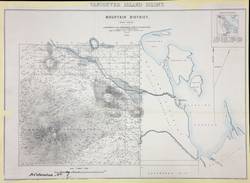
- Geographic Coverage:
- British Columbia--Nanaimo, British Columbia--Vancouver Island, and British Columbia--Mountain Land District
- Coordinates:
- 49.16633, -124.02772, 49.16638, -123.94003, and 49.65064, -125.44939
- Additional Physical Characteristics:
- Scale: 2 Inches - 1 Mile; 1:15,840
- Physical Repository:
- University of Victoria (B.C.). Library
- Collection:
- Frank and Cecilia Sylvester Collection
- Provider:
- University of Victoria (B.C.). Library
- Genre:
- historical maps, maps (documents), and relief maps
- Date Digitized:
- 2008-01-22/2008-01-30
- Technical Note:
- 600 dpi tif, Epson GT-15000 scanner, scanned by KSW, edited by CDW. Metadata created by KD.
- Alternative Title:
- Nanaimo District. Official Map. 1859.
- Language:
- English
- Date Created:
- 1859
- Rights Statement:
- No Copyright - Non-Commercial Use Only
- Resource Type:
- Still Image
- Identifier:
- 105470 and LSV Number: 26T2 ECVI
- Extent:
- 1 sheet ; 61 x 96 cm
- Geographic Coverage:
- British Columbia--Nanaimo
- Coordinates:
- 49.16638, -123.94003
- Additional Physical Characteristics:
- Scale: 20 Chains = 1 Inch
- Physical Repository:
- Land Title and Survey Authority of British Columbia
- Collection:
- Land Title and Survey Authority of British Columbia: Early British Columbia Maps
- Provenance:
- Surveyor General of BC, Legal Surveys Vault
- Provider:
- University of Victoria (B.C.). Library
- Genre:
- relief maps, maps (documents), and historical maps
- Date Digitized:
- 2010-05-28
- Technical Note:
- Cataloguing metadata: Provided by the LTSA and adapted by the University of Victoria Libraries to their requirements.
- Alternative Title:
- Nanaimo District. Official Map. 1859.
- Language:
- English
- Date Created:
- 1859
- Rights Statement:
- No Copyright - Non-Commercial Use Only
- Resource Type:
- Still Image
- Identifier:
- LSV Number: 12T1 LAND DIV
- Geographic Coverage:
- British Columbia--Nanaimo
- Coordinates:
- 49.16638, -123.94003
- Additional Physical Characteristics:
- Scale: 20 Chains - 1 Inch
- Physical Repository:
- Land Title and Survey Authority of British Columbia
- Collection:
- Land Title and Survey Authority of British Columbia: Early British Columbia Maps
- Provenance:
- Surveyor General of BC, Legal Surveys Vault
- Provider:
- University of Victoria (B.C.). Library
- Genre:
- maps (documents) and historical maps
- Date Digitized:
- 2011-09-30
- Technical Note:
- Cataloguing metadata: Provided by the LTSA and adapted by the University of Victoria Libraries to their requirements.