Search
Search Constraints
Start Over Filtering by: Genre maps (documents) ✖ Remove constraint Genre: maps (documents) Subject Neighborhoods ✖ Remove constraint Subject: Neighborhoods
« Previous |
1 - 10 of 20
|
Next »
Number of results to display per page
Search Results
-
- Alternative Title
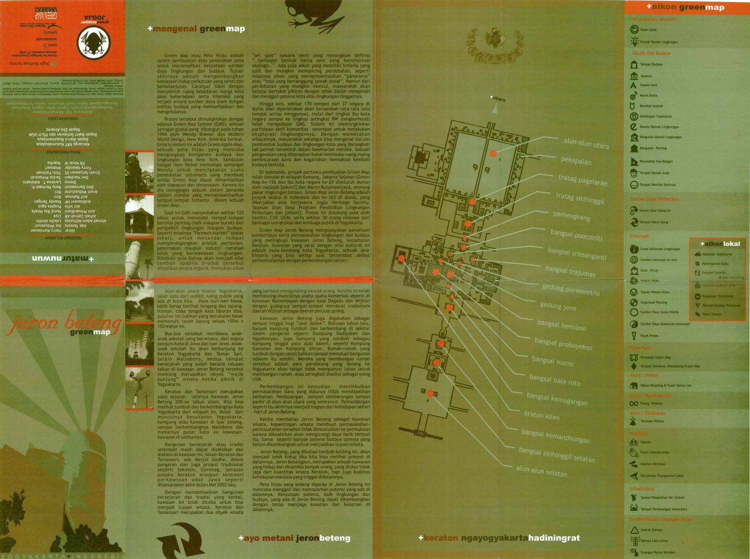
- Jeron Beteng Yogyakarta green map
- Subject
- Sustainable living, Neighborhoods, and Natural areas
- Creator
- Green Mapper Jogja
- Contributor
- Universitas Gadjah Mada and Center for Heritage Conservation Department of Architecture, Faculty of Engineering
- Publisher
- Press, Culture & Education Royal Netherlands Embassy
- Language
- ind
- Date created
- 2002
- Rights Statement
- In Copyright - Educational Use Permitted
- Resource Type
- Text
- Identifier
- Green Map System Number: AS21
- Extent
- 1 map : colour ; 62 x 44 cm
- Geographic Coverage
- Indonesia--Yogyakarta
- Coordinates
- -7.80139, 110.36472
- Chronological Coverage
- 2002
- Collection
- International Green Maps
- Provenance
- Digital files provided by Green Map System, New York, NY.
- Provider
- University of Victoria (B.C.). Library
- Genre
- maps (documents)
- Date Digitized
- 2007-06-19
- Technical Note
- Adobe PDF. Received in digital format. Metadata by PD and MT.
-

- Alternative Title
- Peta Hijau Kemang
- Subject
- Natural areas, Neighborhoods, and Sustainable living
- Creator
- Green Map Indonesia
- Publisher
- Green Map Indonesia
- Language
- ind
- Date created
- 2002
- Rights Statement
- In Copyright - Educational Use Permitted
- Resource Type
- Text
- Identifier
- Green Map System Number: AS33
- Extent
- 1 map : colour
- Geographic Coverage
- Indonesia--Jakarta
- Coordinates
- -6.21462, 106.84513
- Chronological Coverage
- 2002
- Collection
- International Green Maps
- Provenance
- Digital files provided by Green Map System, New York, NY.
- Provider
- University of Victoria (B.C.). Library
- Genre
- maps (documents)
- Date Digitized
- 2007-06-19
- Technical Note
- Adobe PDF. Received in digital format. Metadata by PD and MT.
-

- Alternative Title
- Kenoh Green Map, Tsubame-Sanjo, Nigata Pref. and Niigata prefecture Kenoh Green Map
- Subject
- Neighborhoods, Museums, Outdoor recreation, Recreation areas, Plants, Trees, Wildlife conservation, and Parks
- Creator
- Yokoki, Hiroyuki
- Publisher
- Tsubame-Sanjo Junior Chamber of Commerce
- Language
- jpn
- Date created
- 2003
- Rights Statement
- In Copyright - Educational Use Permitted
- Resource Type
- Text
- Identifier
- Green Map System Number: JP32
- Extent
- 1 map : colour ; 58 x 41 cm
- Geographic Coverage
- Japan--Tagami-machi, Japan--Teradomari-machi, Japan--Sanjō-shi, Japan--Niigata-ken, and Japan--Tsubame-shi
- Coordinates
- 37.61667, 138.95, 37.69828, 139.06947, 37.52343, 138.91748, 37.6645, 138.92518, and 37.58333, 138.73333
- Chronological Coverage
- 2003
- Collection
- International Green Maps
- Provenance
- Digital files provided by Green Map System, New York, NY.
- Provider
- University of Victoria (B.C.). Library
- Genre
- maps (documents)
- Date Digitized
- 2004-06-23
- Technical Note
- 300 dpi TIFF. Born digital resource. Metadata by PD and MT.
-

- Alternative Title
- Community Green Map of Victoria and Region
- Subject
- City planning, Food supply, and Neighborhoods
- Creator
- Common Ground Community Mapping Project
- Contributor
- Dick, Butch and Josephson, Ken
- Publisher
- Green Map System (Firm)
- Language
- eng
- Date created
- 2004
- Rights Statement
- In Copyright - Educational Use Permitted
- Resource Type
- Still Image
- Identifier
- Call Number: Wall map 320 and Call Number: G3514 V5 2004 J6
- Extent
- 1 map on 2 sheets : colour ; 86 x 61 cm
- Geographic Coverage
- British Columbia--Oak Bay, British Columbia--Langford, British Columbia--Central Saanich, British Columbia--View Royal, British Columbia--Esquimalt Lagoon, British Columbia--Victoria Region, British Columbia--Victoria--Cordova Bay, British Columbia--Gulf Islands, British Columbia--Saanich Inlet, British Columbia--Metchosin, British Columbia--Victoria--Colwood, British Columbia--North Saanich, British Columbia--Saanich, British Columbia--Race Rocks, British Columbia--Victoria, British Columbia--Saanich--Elk Lake, British Columbia--Sooke Basin, British Columbia--Becher Bay, and British Columbia--Esquimalt
- Coordinates
- 48.4359, -123.35155
- Chronological Coverage
- 2001/2002
- Additional Physical Characteristics
- Scale: 1:64516
- Collection
- Community Mapping Project
- Provenance
- High resolution maps made available through the UVic Community Mapping Collaboratory in April 2015.Web-ready image files provided by the UVic Community Mapping Collaboratory.
- Provider
- University of Victoria (B.C.). Library
- Genre
- maps (documents) and cadastral maps
- Date Digitized
- 2015-03-26
- Technical Note
- 300 dpi JPG. Born digital resource. Metadata by CDM and MT.
-

- Subject
- Recycling (Waste, etc.), Community gardens, Cycling, Neighborhoods, Culture, Animals, Trees, Parks, Older people, Farmers' markets, Community centers, Outdoor recreation, and Local transit
- Creator
- Green Map System (Firm)
- Contributor
- Green Map System (Firm)
- Publisher
- Green Map System
- Language
- eng
- Date created
- 2005
- Rights Statement
- In Copyright - Educational Use Permitted
- Resource Type
- Still Image
- Identifier
- Green Map System Number: US102
- Extent
- 1 map : colour
- Geographic Coverage
- United States and New York (State)--New York--Flushing Meadows-Corona Park
- Coordinates
- 39.76, -98.5 and 40.7401, -73.84069
- Chronological Coverage
- 2005
- Collection
- International Green Maps
- Provenance
- Digital files provided by Green Map System, New York, NY.
- Provider
- University of Victoria (B.C.). Library
- Genre
- maps (documents)
- Date Digitized
- 2012-01-07
- Technical Note
- 72 dpi JPG. Received in digital format. Metadata by PD and MT.
-

- Subject
- Neighborhoods, Food supply, City planning, and Environmental policy
- Creator
- Baigent, Jane
- Contributor
- Groundworks Learning Centre and Victoria West Community Association
- Publisher
- Green Map System (Firm)
- Language
- eng
- Date created
- 2005
- Rights Statement
- In Copyright - Educational Use Permitted
- Resource Type
- Text
- Identifier
- Call Number: G3514 V5G4 2005 B3 and Call Number: Wall map 325
- Extent
- 1 map on 2 sheets : colour ; 61 x 45 cm
- Geographic Coverage
- British Columbia--Victoria and British Columbia--Victoria--Victoria West
- Coordinates
- 48.4359, -123.35155 and 48.433493538352685, -123.38654816746678
- Chronological Coverage
- 2005
- Additional Physical Characteristics
- Scale: ca. 1:4000
- Collection
- Community Mapping Project
- Provenance
- Digital files provided by University of Victoria Department of Geography.
- Provider
- University of Victoria (B.C.). Library
- Genre
- maps (documents) and road maps
- Date Digitized
- 2013-05-01
- Technical Note
- 500 dpi JPG. Born digital resource. Metadata by CDW and MT.
-

- Alternative Title
- Mapa Verde Barrio Chino cuidad de Nueva York
- Subject
- Neighborhoods, Renewable energy sources, Sustainable urban development, Public art, Farmers' markets, Museums, Sustainable living, Community centers, Culture, and Open spaces
- Creator
- Rubio, Carlos A. Martinez
- Publisher
- Green Map System
- Language
- spa and eng
- Date created
- 2006
- Rights Statement
- In Copyright - Educational Use Permitted
- Resource Type
- Still Image
- Extent
- 1 map : colour
- Geographic Coverage
- United States and New York (State)--New York
- Coordinates
- 40.71427, -74.00597 and 39.76, -98.5
- Chronological Coverage
- 2006
- Collection
- International Green Maps
- Provenance
- Digital files provided by Green Map System, New York, NY.
- Provider
- University of Victoria (B.C.). Library
- Genre
- maps (documents)
- Date Digitized
- 2012-01-10
- Technical Note
- Adobe PDF. Received in digital format. Metadata by PD and MT.
- Keyword in Context
- MapaVerdeChinatown.psd
-

- Alternative Title
- Shelbourne Corridor Action Plan: map and vision survey results
- Subject
- Neighborhoods, City planning, and Sustainable living
- Creator
- Josephson, Ken
- Contributor
- Lydon, Maeve, Common Ground Community Mapping Project, Fingler, Theresa, and University of Victoria (B.C.). Department of Geography
- Publisher
- Green Map System (Firm)
- Language
- eng
- Date created
- 2010
- Rights Statement
- In Copyright - Educational Use Permitted
- Resource Type
- Still Image
- Extent
- 1 map on 2 sheets : colour
- Geographic Coverage
- British Columbia--Victoria and British Columbia--Saanich
- Coordinates
- 48.4359, -123.35155 and 48.54964, -123.36931
- Chronological Coverage
- 2010-01/2010-05
- Additional Physical Characteristics
- Scale: ca. 1:2800
- Collection
- Community Mapping Project
- Provenance
- Digital files provided by University of Victoria Department of Geography.
- Provider
- University of Victoria (B.C.). Library
- Genre
- maps (documents)
- Date Digitized
- 2016-02-15
- Technical Note
- 400 dpi JPG. Born digital resource. Metadata by CDW and MT.
-

- Subject
- Sustainable living, Neighborhoods, and City planning
- Creator
- Josephson, Ken
- Contributor
- University of Victoria (B.C.). Department of Geography, Common Ground Community Mapping Project, Burnett, Charles, Maass, Amy, Jaswall, Harpreet, and Lydon, Maeve
- Publisher
- Green Map System (Firm)
- Language
- eng
- Date created
- 2010
- Rights Statement
- In Copyright - Educational Use Permitted
- Resource Type
- Still Image
- Extent
- 1 map on 2 sheets : colour
- Geographic Coverage
- British Columbia--Victoria and British Columbia--Victoria--South Jubilee
- Coordinates
- 48.428471548089234, -123.33069155714776 and 48.4359, -123.35155
- Chronological Coverage
- 2010
- Collection
- Community Mapping Project
- Provenance
- Digital files provided by University of Victoria Department of Geography.
- Provider
- University of Victoria (B.C.). Library
- Genre
- road maps and maps (documents)
- Date Digitized
- 2016-02-15
- Technical Note
- 400 dpi JPG. Born digital resource. Metadata by CDW and MT.
-

- Alternative Title
- Green Map's sustainable walking tour of the East Village
- Subject
- Recycling (Waste, etc.), Local transit, Sustainable buildings, Natural foods, Thrift shops, Neighborhoods, Public art, Libraries, and Farmers' markets
- Creator
- Green Map System (Firm)
- Contributor
- Green Map System (Firm)
- Publisher
- Green Map System
- Language
- eng
- Date created
- 2011
- Rights Statement
- In Copyright - Educational Use Permitted
- Resource Type
- Text
- Identifier
- Green Map System Number: US112
- Extent
- 1 map : colour ; 27 x 21 cm
- Geographic Coverage
- New York (State)--New York--Manhattan and United States
- Coordinates
- 40.78343, -73.96625 and 39.76, -98.5
- Chronological Coverage
- 2011
- Collection
- International Green Maps
- Provenance
- Digital files provided by Green Map System, New York, NY.
- Provider
- University of Victoria (B.C.). Library
- Genre
- maps (documents)
- Date Digitized
- 2012-01-10
- Technical Note
- Adobe PDF. Received in digital format. Metadata by PD and MT.
- Keyword in Context
- Microsoft Word - FINAL Brochure.doc 220A East 4th St. New York, NY 10009 Explore and add to the map at OpenGreenMap.org/NYC Or email us at info@greenmap.org 1. Temperance Fountain 2. Sustainable NYC 3. New York Public Library, Tompkins Square Park Bra...